- National Register of Historic Places listings in Lake County, Indiana
-
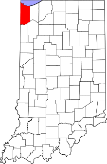 Location of Lake County in Indiana
This is a list of the National Register of Historic Places listings in Lake County, Indiana.
This is intended to be a complete list of the properties and districts on the National Register of Historic Places in Lake County, Indiana, United States. Latitude and longitude coordinates are provided for many National Register properties and districts; these locations may be seen together in a Google map.[1]
There are 59 properties and districts listed on the National Register in the county, including 1 National Historic Landmark.
-
- This National Park Service list is complete through NPS recent listings posted November 10, 2011.[2]
Current listings
[3] Landmark name [4] Image Date listed Location City or town Summary 1 Walter Allman House December 27, 2010 102 S. East St.
41°25′05″N 87°21′47″W / 41.418056°N 87.363056°WCrown Point 2 American Sheet and Tin Mill Apartment Building June 17, 2009 633 W. 4th Ave.
41°36′14″N 87°20′42″W / 41.603889°N 87.345°WGary Concrete in Steel City: The Edison Concept Houses of Gary Indiana MPS 3 Louis J. Bailey Branch Library-Gary International Institute September 29, 2004 1501 W. Madison St.
41°35′15″N 87°20′28″W / 41.5875°N 87.341111°WGary 4 James Brannon House March 21, 2011 260 Burnham St.
41°17′43″N 87°24′50″W / 41.295278°N 87.413889°WLowell 5 Buckley Homestead December 6, 1984 3606 Belshaw Rd.
41°16′53″N 87°22′43″W / 41.281389°N 87.378611°WLowell 6 Wellington A. Clark House June 6, 2001 227 S. Court St.
41°24′57″N 87°21′57″W / 41.415833°N 87.365833°WCrown Point 7 Crown Point Courthouse Square Historic District 
March 22, 2004 Roughly bounded by Clark St., the alley east of Main St., Hack Ct., and Court St.; also roughly bounded by Robinson, East, Walnut, and Court Sts.; also 208 Main St.
41°25′02″N 87°21′56″W / 41.417333°N 87.365456°WCrown Point Second set of boundaries represents a boundary adjustment of December 8, 2005; 208 Main represents a boundary increase of March 29, 2007 8 Morse Dell Plain House and Garden April 1, 1998 7109 Knickerbocker Parkway
41°35′03″N 87°28′39″W / 41.584167°N 87.4775°WHammond 9 Ralph Waldo Emerson School June 9, 1995 716 E. 7th Ave.
41°35′57″N 87°19′39″W / 41.599167°N 87.3275°WGary 10 First Unitarian Church of Hobart 
September 9, 1999 497 Main St.
41°31′48″N 87°15′12″W / 41.53°N 87.253333°WHobart 11 Forest-Ivanhoe Residential Historic District March 31, 2010 Roughly bounded by 172nd Pl., the eastern side of Forest Ave. south to its end, and the Little Calumet River
41°34′51″N 87°31′25″W / 41.580931°N 87.523533°WHammond 12 Forest-Moraine Residential Historic District September 23, 2010 Roughly bounded by Wildwood Rd., 165th St., Hohman Ave. and State Line Ave.
41°35′53″N 87°31′24″W / 41.598056°N 87.523333°WHammond Historic Residential Suburbs in the U.S., 1830-1960 MPS 13 Forest-Southview Residential Historic District September 23, 2010 Roughly bounded by 165th St., Hohman Ave., Locust St. and State Line Ave.
41°35′37″N 87°31′25″W / 41.593611°N 87.523611°WHammond Historic Residential Suburbs in the U.S., 1830-1960 MPS 14 Gary Bathing Beach Aquatorium 
November 25, 1994 One Marquette Dr., Marquette Park
41°37′11″N 87°15′24″W / 41.619722°N 87.256667°WGary 15 Gary City Center Historic District 
November 25, 1994 Roughly Broadway from the Chicago SouthShore and South Bend railroad tracks to 9th Ave.
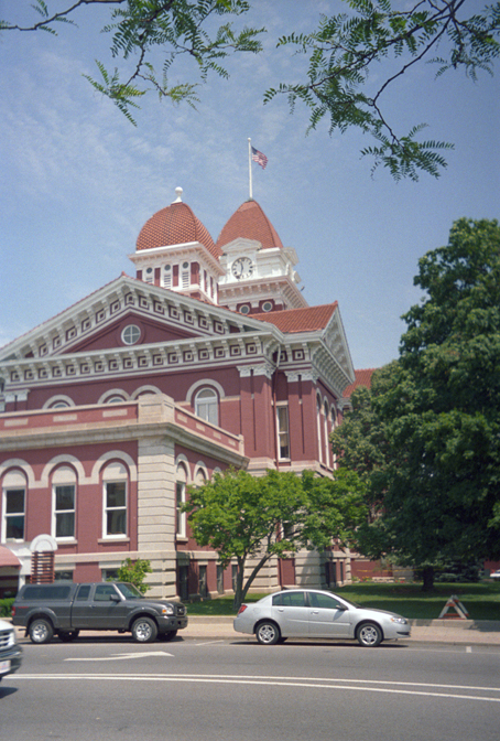
41°36′01″N 87°20′13″W / 41.600278°N 87.336944°WGary 16 Gary Land Company Building 
May 8, 1979 4th Ave. and Pennsylvania St.
41°36′15″N 87°20′00″W / 41.604167°N 87.333333°WGary 17 Gary Public Schools Memorial Auditorium November 25, 1994 700-734 Massachusetts St.
41°35′53″N 87°20′10″W / 41.598056°N 87.336111°WGary 18 E.J. and E. Griffith Interlocking Tower 
September 28, 2003 201 S. Broad St.
41°31′16″N 87°25′39″W / 41.521111°N 87.4275°WGriffith Elgin, Joliet and Eastern Railway 19 Griffith Grand Trunk Depot 
September 28, 2003 201 S. Broad St.
41°31′16″N 87°25′39″W / 41.521111°N 87.4275°WGriffith 20 Melvin A. Halsted House December 8, 1978 201 E. Main St.
41°17′36″N 87°25′24″W / 41.293333°N 87.423333°WLowell 21 Hobart Carnegie Library 
July 15, 1982 706 E. 4th St.
41°31′56″N 87°15′49″W / 41.532222°N 87.263611°WHobart 22 Hohman Avenue Commercial Historic District March 21, 2011 Approximately three blocks lining Hohman Ave. between Clinton St. and Rimbach St.
41°37′02″N 87°31′19″W / 41.617222°N 87.521944°WHammond 23 Hoosier Theater Building February 18, 1987 1329-1335 119th St.
41°40′47″N 87°29′47″W / 41.679722°N 87.496389°WWhiting 24 Ibach House December 27, 2010 1908 Ridge Rd.
41°33′27″N 87°28′57″W / 41.5575°N 87.4825°WMunster 25 Indiana Harbor Public Library September 15, 2005 3605 Grand Ave.
41°38′51″N 87°26′56″W / 41.6475°N 87.448889°WEast Chicago 26 Jackson-Monroe Terraces Historic District June 17, 2009 404-423 Jackson St. and 408-426 Monroe St.
41°36′13″N 87°20′41″W / 41.603581°N 87.344614°WGary Concrete in Steel City: The Edison Concept Houses of Gary Indiana MPS 27 Kingsbury-Doak Farmhouse September 15, 2005 4411 E 153rd Ave.
41°20′20″N 87°17′10″W / 41.338889°N 87.286111°WHebron 28 Knights of Columbus Building March 1, 1984 333 W. 5th Ave.
41°36′06″N 87°20′29″W / 41.601667°N 87.341389°WGary 29 Lake County Courthouse 
May 17, 1973 Public Sq.
41°25′02″N 87°21′57″W / 41.417222°N 87.365833°WCrown Point 30 Lake County Sanatorium Nurses Home June 17, 2005 2323 N. Main St.
41°27′04″N 87°21′55″W / 41.451111°N 87.365278°WCrown Point 31 Lake County Sheriff's House and Jail January 4, 1989 232 S. Main St.
41°24′57″N 87°21′51″W / 41.415833°N 87.364167°WCrown Point 32 Lassen Hotel July 7, 1981 7808 W. 138th Pl.
41°22′06″N 87°25′30″W / 41.368333°N 87.425°WCedar Lake 33 Lowell Commercial Historic District March 26, 2003 305-519 Commercial Ave. and 108-110 Clark St.
41°17′30″N 87°25′23″W / 41.291667°N 87.423056°WLowell 34 Albert Maack House June 23, 2011 498 S. Court St.
41°24′34″N 87°21′58″W / 41.409583°N 87.366111°WCrown Point 35 Marktown Historic District 
February 20, 1975 Bounded by Pine, Riley, Dickey, and 129th Sts.
41°39′31″N 87°28′04″W / 41.658611°N 87.467778°WEast Chicago 36 Joseph Ernest Meyer House March 1, 1984 1370 Joliet St.
41°29′26″N 87°29′48″W / 41.490556°N 87.496667°WDyer 37 Miller Town Hall July 7, 1978 Junction of Miller Ave., Old Hobart Rd., and Grand Boulevard
41°36′02″N 87°15′41″W / 41.600556°N 87.261389°WGary 38 Monon Park Dancing Pavillion January 3, 2001 13701 Lauerman St.
41°22′07″N 87°26′22″W / 41.368611°N 87.439444°WCedar Lake 39 Monroe Terrace Historic District June 17, 2009 304-318 Monroe St.
41°36′19″N 87°20′36″W / 41.605278°N 87.343333°WGary Concrete in Steel City: The Edison Concept Houses of Gary Indiana MPS 40 Morgan-Skinner-Boyd Homestead December 27, 2010 111 E. 73rd Ave.
41°29′08″N 87°20′02″W / 41.485556°N 87.333889°WMerrillville 41 Morningside Historic District September 24, 2009 Roughly bounded by the eastern side of Washington, the western side of Jefferson, and 47th and 48th Sts.
41°31′56″N 87°20′19″W / 41.5321°N 87.338608°WGary 42 Charles E. Nichols House June 24, 2010 231 West Commercial Ave.
41°17′24″N 87°25′38″W / 41.29°N 87.427222°WLowell 43 Northern States Life Insurance Company June 24, 2010 5935 Hohman Ave.
41°36′21″N 87°31′19″W / 41.605833°N 87.521944°WHammond 44 Pennsylvania Railroad Station 
March 1, 1984 1001 Lillian St.
41°32′03″N 87°14′49″W / 41.534167°N 87.246944°WHobart 45 Polk Street Concrete Cottage Historic District September 15, 2011 604-614 Polk St.
41°36′N 87°21′W / 41.6°N 87.35°WGary Concrete in Steel City: The Edison Concept Houses of Gary Indiana MPS 46 Polk Street Terraces Historic District June 17, 2009 404-422 and 437-455 Polk St.
41°36′13″N 87°20′59″W / 41.603611°N 87.349722°WGary 47 John Ross Farm March 27, 1996 3815 E. State Road 231
41°22′14″N 87°17′21″W / 41.370556°N 87.289167°WLeroy 48 J. Claude Rumsey House December 22, 2008 709 Michigan Ave.
41°17′43″N 87°25′01″W / 41.295314°N 87.416897°WLowell 49 Southmoor Apartment Hotel March 21, 2011 5946 Hohman Ave.
41°36′20″N 87°31′19″W / 41.605556°N 87.521944°WHammond 50 Stallbohm Barn-Kaske House April 1, 1998 1154 Ridge Rd.
41°33′32″N 87°30′00″W / 41.558889°N 87.5°WMunster 51 State Bank of Hammond Building September 27, 1984 5444-5446 Calumet Ave.
41°36′52″N 87°30′33″W / 41.614444°N 87.509167°WHammond 52 State Street Commercial Historic District September 17, 1999 Roughly State St. between Sohl and Bulletin Ave.
41°37′07″N 87°31′00″W / 41.618611°N 87.516667°WHammond 53 Van Buren Terrace Historic District June 22, 2007 336-354 Van Buren St.
41°36′17″N 87°20′47″W / 41.604722°N 87.346389°WGary 54 West Fifth Avenue Apartments Historic District May 17, 1984 Roughly 5th Ave. from Taft to Pierce St.
41°36′06″N 87°21′29″W / 41.601667°N 87.358056°WGary 55 William Whitaker Landscape and House September 9, 1999 472 S. Main
41°24′36″N 87°21′50″W / 41.41°N 87.363889°WCrown Point 56 Whiting Memorial Community House February 8, 1980 1938 Clark St.
41°40′41″N 87°29′47″W / 41.678056°N 87.496389°WWhiting 57 George John Wolf House June 21, 2007 7220 Forest Ave.
41°35′03″N 87°31′26″W / 41.584167°N 87.523889°WHammond 58 John Wood Old Mill October 10, 1975 East of Merrillville on State Road 330
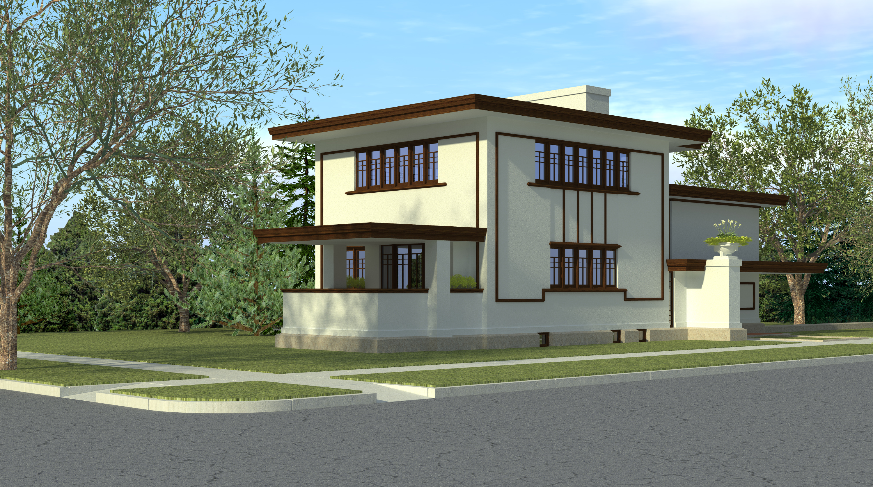
41°28′35″N 87°13′18″W / 41.476389°N 87.221667°WMerrillville 59 Wilbur Wynant House 
October 18, 2002 600 Fillmore St.
41°36′00″N 87°21′05″W / 41.6°N 87.351389°WGary A house discovered in 1995 to have been designed by Frank Lloyd Wright. Largely burned in 2006. See also
- List of National Historic Landmarks in Indiana
- National Register of Historic Places listings in Indiana
References
- ^ The latitude and longitude information provided in this table was derived originally from the National Register Information System, which has been found to be fairly accurate for about 99% of listings. For about 1% of NRIS original coordinates, experience has shown that one or both coordinates are typos or otherwise extremely far off; some corrections may have been made. A more subtle problem causes many locations to be off by up to 150 yards, depending on location in the country: most NRIS coordinates were derived from tracing out latitude and longitudes off of USGS topographical quadrant maps created under North American Datum of 1927, which differs from the current, highly accurate GPS system used by Google maps. Chicago is about right, but NRIS longitudes in Washington are higher by about 4.5 seconds, and are lower by about 2.0 seconds in Maine. Latitudes differ by about 1.0 second in Florida. Some locations in this table may have been corrected to current GPS standards.
- ^ "National Register of Historic Places: Weekly List Actions". National Park Service, United States Department of the Interior. Retrieved on November 10, 2011.
- ^ Numbers represent an ordering by significant words. Various colorings, defined here, differentiate National Historic Landmark sites and National Register of Historic Places Districts from other NRHP buildings, structures, sites or objects.
- ^ "National Register Information System". National Register of Historic Places. National Park Service. . http://nrhp.focus.nps.gov/natreg/docs/All_Data.html.
U.S. National Register of Historic Places Topics Lists by states Alabama • Alaska • Arizona • Arkansas • California • Colorado • Connecticut • Delaware • Florida • Georgia • Hawaii • Idaho • Illinois • Indiana • Iowa • Kansas • Kentucky • Louisiana • Maine • Maryland • Massachusetts • Michigan • Minnesota • Mississippi • Missouri • Montana • Nebraska • Nevada • New Hampshire • New Jersey • New Mexico • New York • North Carolina • North Dakota • Ohio • Oklahoma • Oregon • Pennsylvania • Rhode Island • South Carolina • South Dakota • Tennessee • Texas • Utah • Vermont • Virginia • Washington • West Virginia • Wisconsin • WyomingLists by territories Lists by associated states Other Municipalities and communities of Lake County, Indiana Cities Crown Point | East Chicago | Gary | Hammond | Hobart | Lake Station | Whiting

Towns Cedar Lake | Dyer | Griffith | Highland | Lowell | Merrillville | Munster | New Chicago | St. John | Schererville | Schneider | Winfield
Townships Calumet | Cedar Creek | Center | Eagle Creek | Hanover | Hobart | North | Ross | St. John | West Creek | Winfield
Unincorporated
communitiesAinsworth | Belshaw | Brunswick | Creston | Deep River | Deer Creek | Dinwiddie | Green Acres | Hawthorne Hills | Klaasville | Kreitzburg | Lake Dalecarlia | Lake Hills | Lakes of the Four Seasons‡ | Leroy | Liberty Park | Liverpool | New Elliott | North Hayden | Orchard Grove | Palmer | Range Line | Rolling Hill Estates | Ross | Shady Lawn | Shelby | Southeast Grove | Southmoor Park | Van Loon | Wald View | Woodmar
Footnotes ‡This populated place also has portions in an adjacent county or counties
Categories:- National Register of Historic Places in Lake County, Indiana
- National Register of Historic Places in Indiana by county
-


Wikimedia Foundation. 2010.