- National Register of Historic Places listings in LaPorte County, Indiana
-
 Location of LaPorte County in Indiana
This is a list of the National Register of Historic Places listings in LaPorte County, Indiana.
This is intended to be a complete list of the properties and districts on the National Register of Historic Places in LaPorte County, Indiana, United States. Latitude and longitude coordinates are provided for many National Register properties and districts; these locations may be seen together in a Google map.[1]
There are 16 properties and districts listed on the National Register in the county.
-
- This National Park Service list is complete through NPS recent listings posted November 10, 2011.[2]
Current listings
[3] Landmark name [4] Image Date listed Location City or town Summary 1 Barker House 
December 7, 2001 444 Barker St.
41°41′17″N 86°52′58″W / 41.688056°N 86.882778°WMichigan City Shirley Heinze Land Trust offices and Barker Woods Nature Preserve 2 John H. Barker Mansion 
October 10, 1975 631 Washington St.
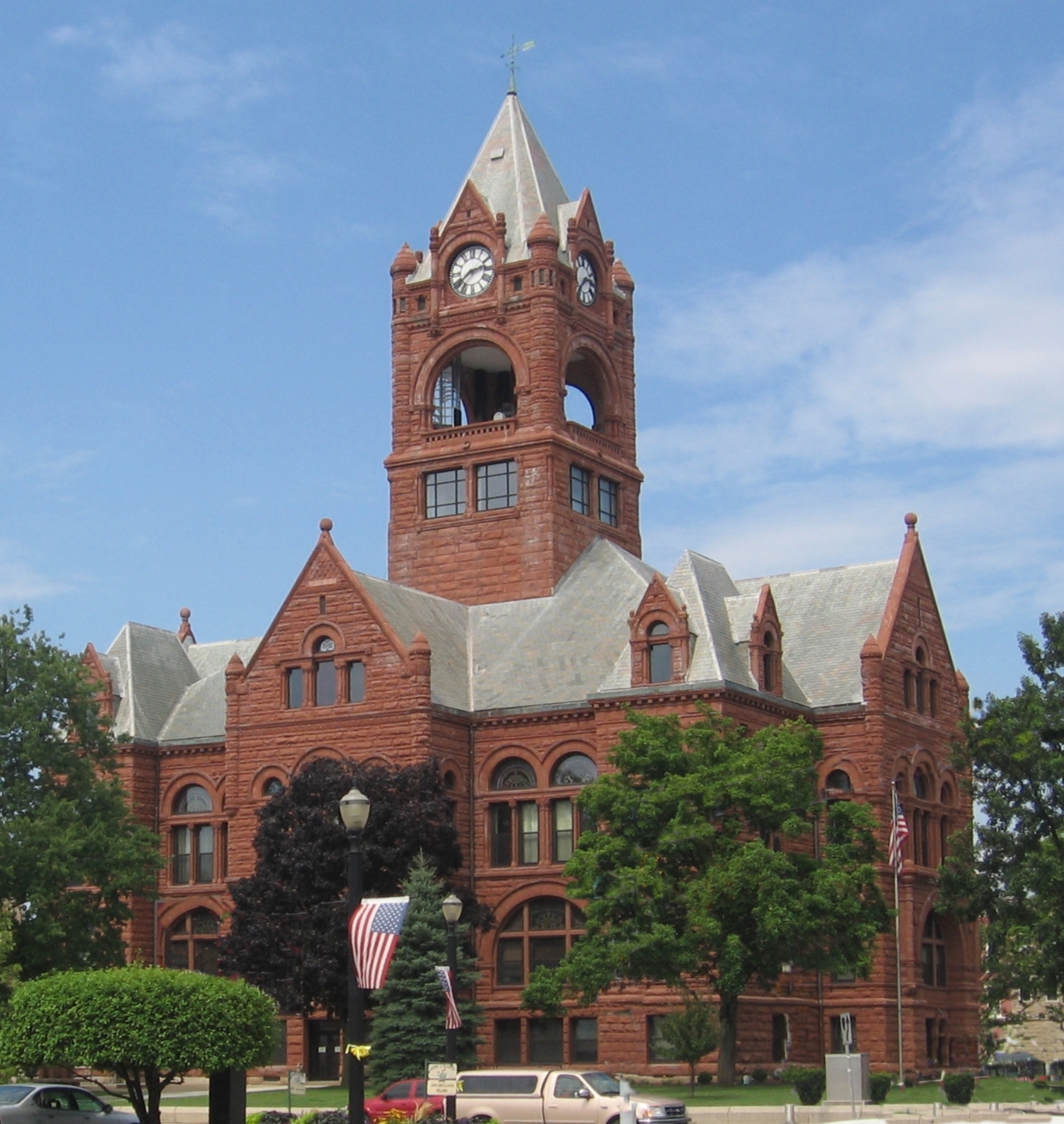
41°42′54″N 86°54′09″W / 41.715°N 86.9025°WMichigan City Michigan City Civic Center 3 Downtown LaPorte Historic District 
September 15, 1983 Roughly bounded by State, Jackson, Maple, and Chicago Sts.
41°36′39″N 86°43′17″W / 41.610833°N 86.721389°WLaPorte 4 First Congregational Church of Michigan City 
December 7, 2001 531 Washington St.
41°42′57″N 86°54′12″W / 41.715833°N 86.903333°WMichigan City 5 Garrettson-Baine-Bartholomew House 
December 7, 2001 2921 Franklin St.
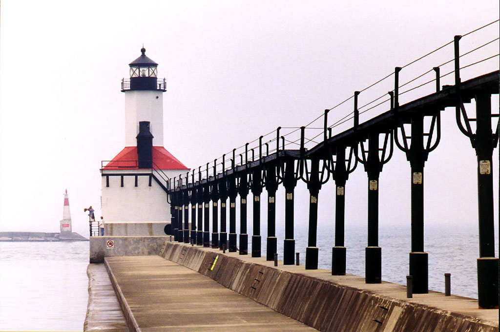
41°41′50″N 86°53′39″W / 41.697222°N 86.894167°WMichigan City 6 Michigan City East Pierhead Light Tower and Elevated Walk 
February 17, 1988 Eastern side of the entrance to Michigan City Harbor
41°43′41″N 86°54′35″W / 41.728056°N 86.909722°WMichigan City 7 Michigan City Lighthouse 
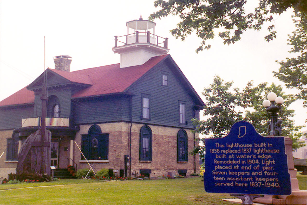
November 5, 1974 Washington Park
41°43′22″N 86°54′21″W / 41.722778°N 86.905833°WMichigan City 8 Michigan City Post Office 
June 15, 2000 126 E. 5th St.
41°43′05″N 86°54′03″W / 41.718056°N 86.900833°WMichigan City In 2010, the building was being used as a law office. 9 Francis H. Morrison House December 6, 1984 1217 Michigan Ave.
41°36′23″N 86°43′00″W / 41.606389°N 86.716667°WLaPorte 10 Michigan City 11 William Orr House March 22, 1984 4076 W. Small Rd.
41°36′36″N 86°46′41″W / 41.61°N 86.778056°WLaPorte 12 Pinehurst Hall June 3, 1976 3042 N. U.S. Route 35
41°39′03″N 86°45′35″W / 41.650833°N 86.759722°WLaPorte 13 Pinhook Methodist Church and Cemetery 
September 24, 2009 8001 State Road 2
41°33′48″N 86°51′27″W / 41.563233°N 86.857508°WLaPorte 14 Marion Ridgeway Polygonal Barn May 27, 1993 U.S. Route 35 north of its junction with Crescent Dr.
41°35′24″N 86°42′09″W / 41.59°N 86.7025°WLaPorte 15 Everel S. Smith House 
December 12, 1990 56 W. Jefferson St.
41°32′35″N 86°53′52″W / 41.543056°N 86.897778°WWestville 16 Washington Park June 26, 1991 Roughly bounded by Lake Michigan, Krueger St., Trail Creek, Lakeshore Dr., Heisman Harbor Rd., and Browne Basin Rd.
41°43′34″N 86°54′03″W / 41.726111°N 86.900833°WMichigan City See also
- List of National Historic Landmarks in Indiana
- National Register of Historic Places listings in Indiana
References
- ^ The latitude and longitude information provided in this table was derived originally from the National Register Information System, which has been found to be fairly accurate for about 99% of listings. For about 1% of NRIS original coordinates, experience has shown that one or both coordinates are typos or otherwise extremely far off; some corrections may have been made. A more subtle problem causes many locations to be off by up to 150 yards, depending on location in the country: most NRIS coordinates were derived from tracing out latitude and longitudes off of USGS topographical quadrant maps created under the North American Datum of 1927, which differs from the current, highly accurate WGS84 GPS system used by Google maps. Chicago is about right, but NRIS longitudes in Washington are higher by about 4.5 seconds, and are lower by about 2.0 seconds in Maine. Latitudes differ by about 1.0 second in Florida. Some locations in this table may have been corrected to current GPS standards.
- ^ "National Register of Historic Places: Weekly List Actions". National Park Service, United States Department of the Interior. Retrieved on November 10, 2011.
- ^ Numbers represent an ordering by significant words. Various colorings, defined here, differentiate National Historic Landmark sites and National Register of Historic Places Districts from other NRHP buildings, structures, sites or objects.
- ^ "National Register Information System". National Register of Historic Places. National Park Service. . http://nrhp.focus.nps.gov/natreg/docs/All_Data.html.
U.S. National Register of Historic Places Topics Lists by states Alabama • Alaska • Arizona • Arkansas • California • Colorado • Connecticut • Delaware • Florida • Georgia • Hawaii • Idaho • Illinois • Indiana • Iowa • Kansas • Kentucky • Louisiana • Maine • Maryland • Massachusetts • Michigan • Minnesota • Mississippi • Missouri • Montana • Nebraska • Nevada • New Hampshire • New Jersey • New Mexico • New York • North Carolina • North Dakota • Ohio • Oklahoma • Oregon • Pennsylvania • Rhode Island • South Carolina • South Dakota • Tennessee • Texas • Utah • Vermont • Virginia • Washington • West Virginia • Wisconsin • WyomingLists by territories Lists by associated states Other Municipalities and communities of LaPorte County, Indiana Cities 
Towns Townships Unincorporated
communitiesAlida | Ambler | Andry | Beattys Corner | Birchim | Byron | Door Village | Duneland Beach | Durham | Fish Lake | Hanna | Hesston | Hicks | Hillside | Holmesville | Hudson Lake | Kankakee | Lake Park | Magee | Mill Creek | Monroe Manor | Oakwood | Orchard Highlands | Otis | Pinhook | Pinola | Plainfield | Riverside | Rolling Prairie | Salem Heights | Smith | South Center | South Wanatah | Springfield | Springville | Stillwell | Summit | Tee Lake | Thomaston | Tracy | Union Center | Union Mills | Waterford | Wellsboro | Wilders
Categories:- LaPorte County, Indiana
- National Register of Historic Places in Indiana by county
- National Register of Historic Places in LaPorte County, Indiana
-


Wikimedia Foundation. 2010.