- National Register of Historic Places listings in LaGrange County, Indiana
-
 Location of Lagrange County in Indiana
This is a list of the National Register of Historic Places listings in LaGrange County, Indiana.
This is intended to be a complete list of the properties and districts on the National Register of Historic Places in Lagrange County, Indiana, United States. Latitude and longitude coordinates are provided for many National Register properties and districts; these locations may be seen together in a Google map.[1]
There are 7 properties and districts listed on the National Register in the county.
-
- This National Park Service list is complete through NPS recent listings posted November 10, 2011.[2]
Current listings
[3] Landmark name [4] Image Date listed Location City or town Summary 1 John Badlam Howe Mansion September 14, 1995 W. Union St.
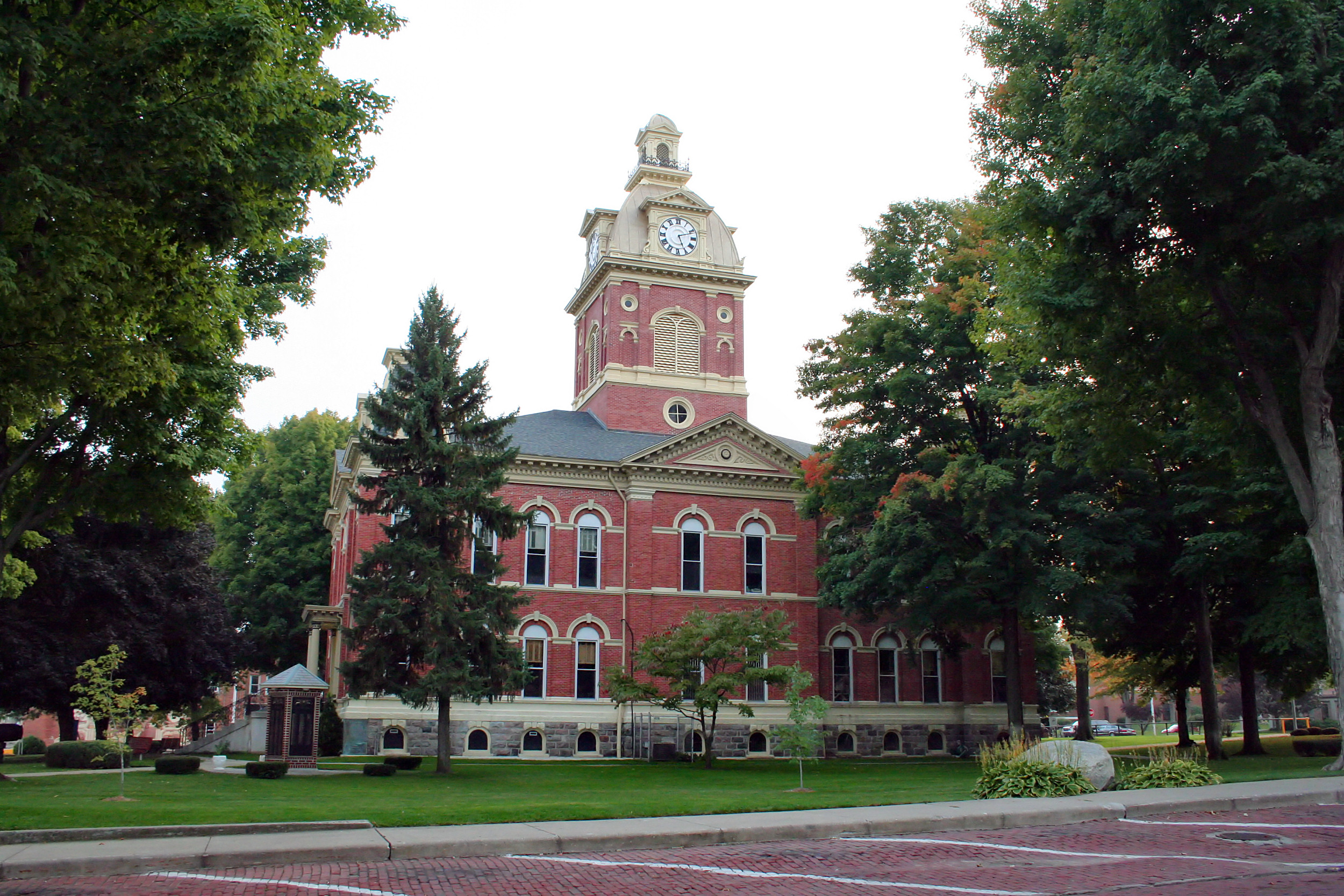
41°43′28″N 85°25′28″W / 41.724444°N 85.424444°WHowe 2 La Grange County Courthouse 
July 17, 1980 Detroit St.
41°38′40″N 85°25′07″W / 41.644444°N 85.418611°WLa Grange 3 Olde Store (John O'Ferrell Store) October 29, 1975 West and 2nd Sts.
41°41′08″N 85°16′46″W / 41.685556°N 85.279444°WMongo 4 St. James Memorial Chapel September 16, 2001 State Road 9, just south of County Road 600 N
41°43′28″N 85°25′29″W / 41.724444°N 85.424722°WHowe 5 Star Milling and Electric Company Historic District September 14, 1995 Junction of County Roads 505 W and 700 N
41°44′54″N 85°26′14″W / 41.748333°N 85.437222°WHowe 6 Samuel P. Williams House August 11, 1980 101 South St.
41°43′19″N 85°25′07″W / 41.721944°N 85.418611°WHowe 7 Menno Yoder Polygonal Barn April 2, 1993 County Road 250N, ¾ miles west of its junction with State Road 5
41°40′30″N 85°35′47″W / 41.675°N 85.596389°WShipshewana See also
- List of National Historic Landmarks in Indiana
- National Register of Historic Places listings in Indiana
References
- ^ The latitude and longitude information provided in this table was derived originally from the National Register Information System, which has been found to be fairly accurate for about 99% of listings. For about 1% of NRIS original coordinates, experience has shown that one or both coordinates are typos or otherwise extremely far off; some corrections may have been made. A more subtle problem causes many locations to be off by up to 150 yards, depending on location in the country: most NRIS coordinates were derived from tracing out latitude and longitudes off of USGS topographical quadrant maps created under North American Datum of 1927, which differs from the current, highly accurate GPS system used by Google maps. Chicago is about right, but NRIS longitudes in Washington are higher by about 4.5 seconds, and are lower by about 2.0 seconds in Maine. Latitudes differ by about 1.0 second in Florida. Some locations in this table may have been corrected to current GPS standards.
- ^ "National Register of Historic Places: Weekly List Actions". National Park Service, United States Department of the Interior. Retrieved on November 10, 2011.
- ^ Numbers represent an ordering by significant words. Various colorings, defined here, differentiate National Historic Landmark sites and National Register of Historic Places Districts from other NRHP buildings, structures, sites or objects.
- ^ "National Register Information System". National Register of Historic Places. National Park Service. . http://nrhp.focus.nps.gov/natreg/docs/All_Data.html.
U.S. National Register of Historic Places Topics Lists by states Alabama • Alaska • Arizona • Arkansas • California • Colorado • Connecticut • Delaware • Florida • Georgia • Hawaii • Idaho • Illinois • Indiana • Iowa • Kansas • Kentucky • Louisiana • Maine • Maryland • Massachusetts • Michigan • Minnesota • Mississippi • Missouri • Montana • Nebraska • Nevada • New Hampshire • New Jersey • New Mexico • New York • North Carolina • North Dakota • Ohio • Oklahoma • Oregon • Pennsylvania • Rhode Island • South Carolina • South Dakota • Tennessee • Texas • Utah • Vermont • Virginia • Washington • West Virginia • Wisconsin • WyomingLists by territories Lists by associated states Other Municipalities and communities of LaGrange County, Indiana Towns LaGrange | Shipshewana | Topeka | Wolcottville‡

Townships Bloomfield | Clay | Clearspring | Eden | Greenfield | Johnson | Lima | Milford | Newbury | Springfield | Van Buren
Unincorporated
communitiesBeatys Beach | Brighton | Brushy Prairie | Eddy | Elmira | Emma | Gravel Beach | Greenfield Mills | Greenwood | Hartzel | Honeyville | Howe | Indianola | Lakeview | Mongo | Mount Pisgah | Ontario | Plato | Ramblewood | Scott | Seyberts | Shady Nook | South Milford | Star Mill | Stony Creek | Stroh | Timberhurst | Valentine | Webers Landing | Witmer Manor | Woodland Park | Woodruff
Footnotes ‡This populated place also has portions in an adjacent county or counties
Categories:- LaGrange County, Indiana
- National Register of Historic Places in Indiana by county
-

Wikimedia Foundation. 2010.