- National Register of Historic Places listings in Kosciusko County, Indiana
-
 Location of Kosciusko County in Indiana
This is a list of the National Register of Historic Places listings in Kosciusko County, Indiana.
This is intended to be a complete list of the properties and districts on the National Register of Historic Places in Kosciusko County, Indiana, United States. Latitude and longitude coordinates are provided for many National Register properties and districts; these locations may be seen together in a Google map.[1]
There are 15 properties and districts listed on the National Register in the county.
-
- This National Park Service list is complete through NPS recent listings posted November 10, 2011.[2]
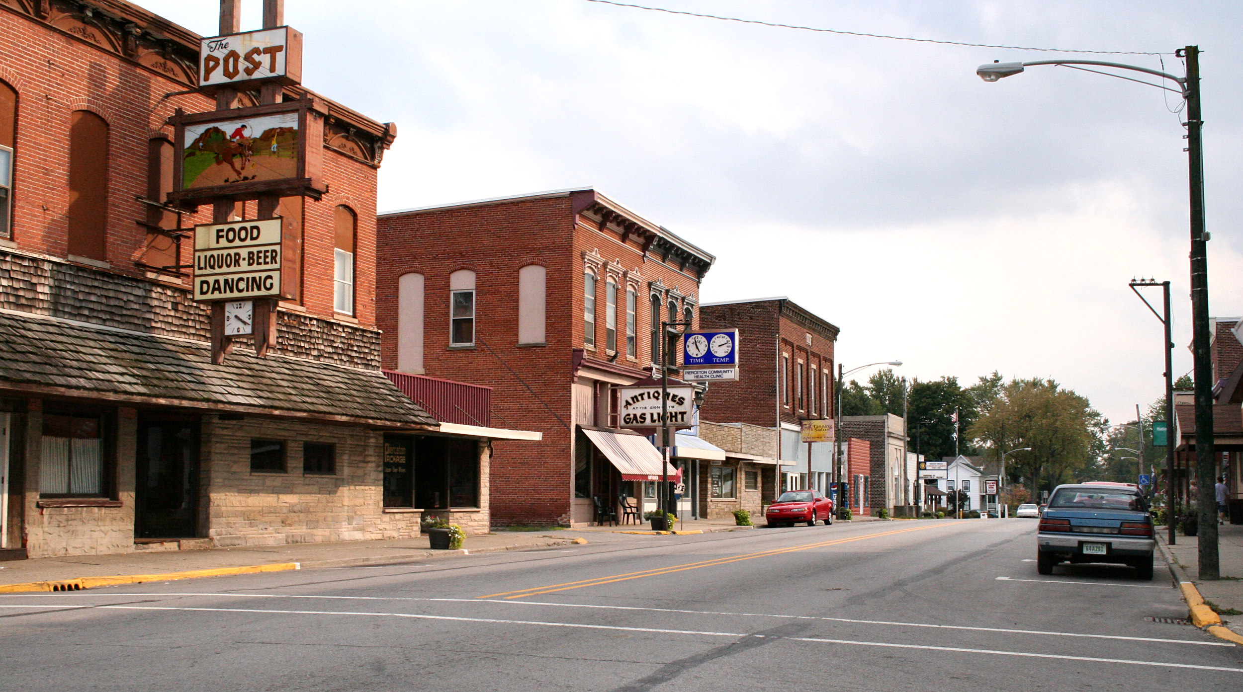
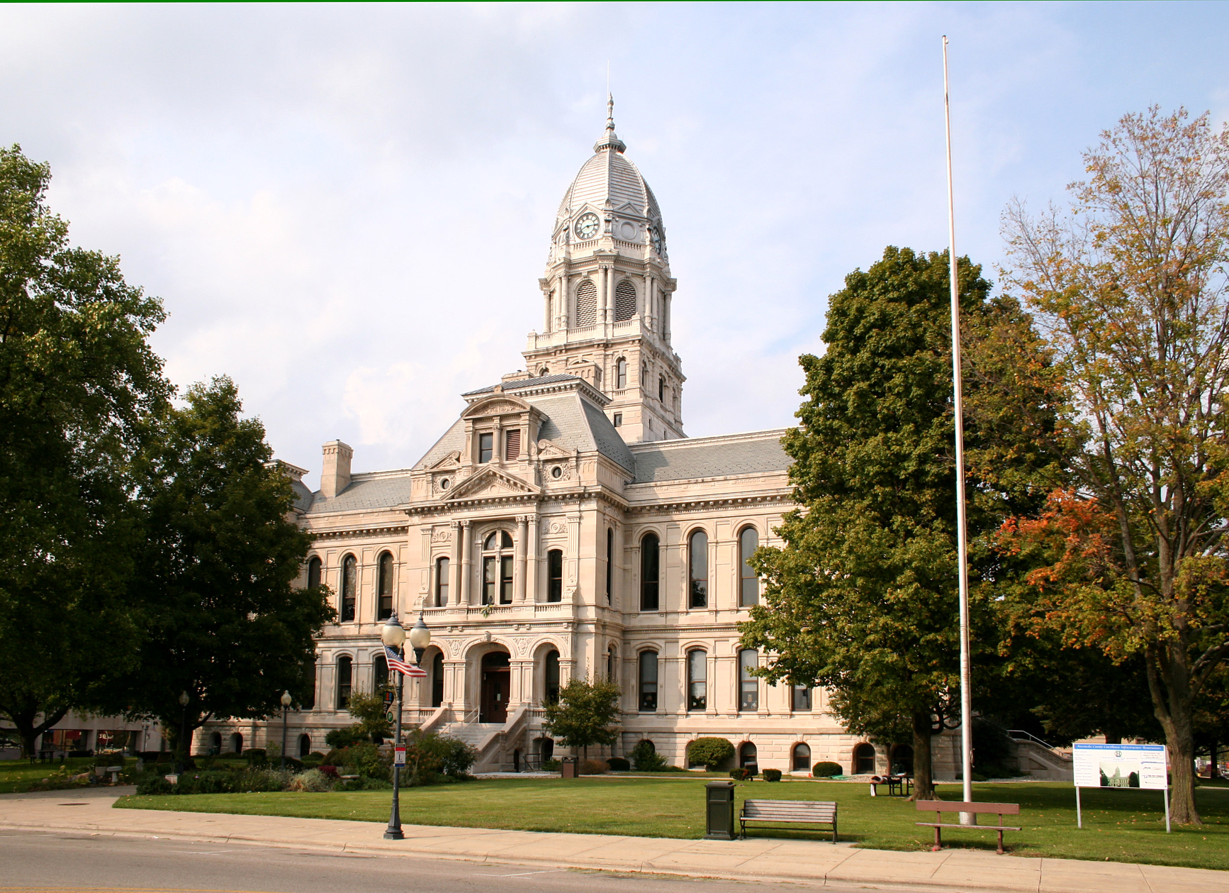
Current listings
[3] Landmark name [4] Image Date listed Location City or town Summary 1 Chinworth Bridge 
January 2, 1997 Junction of Old U.S. Route 30 and Road 350 W, across the Tippecanoe River
41°14′49″N 85°54′38″W / 41.246944°N 85.910556°WWarsaw 2 DIXIE (sternwheeler) September 24, 2009 400 block of S. Dixie Dr.
41°14′25″N 85°51′01″W / 41.240278°N 85.850278°WNorth Webster 3 East Fort Wayne Street Historic District May 27, 1993 503-613 E. Fort Wayne St.
41°14′25″N 85°51′01″W / 41.240278°N 85.850278°WWarsaw 4 Hall Farm September 16, 1992 Junction of 600 N and 400 W
41°19′12″N 85°55′11″W / 41.32°N 85.919722°WClunette 5 Kosciusko County Jail 
December 8, 1978 Main and Indiana Sts.
41°14′19″N 85°51′20″W / 41.238611°N 85.855556°WWarsaw 6 Leesburg Historic District May 27, 1993 100 block of E. and W. Van Buren St.
41°19′54″N 85°51′00″W / 41.331667°N 85.85°WLeesburg 7 Mock School December 27, 2010 Northwestern corner of the junction of N550E and E875N
41°21′40″N 85°44′24″W / 41.361111°N 85.74°WSyracuse Indiana's Public Common and High Schools MPS 8 Robert Orr Polygonal Barn April 2, 1993 State Road 13, ½ mile north of its junction with Road 150 N
41°15′43″N 85°42′12″W / 41.261944°N 85.703333°WNorth Webster 9 Pierceton Historic District 
September 4, 1992 N. 1st St. from Catholic St. to the former Conrail railroad tracks
41°11′59″N 85°42′19″W / 41.199722°N 85.705278°WPierceton 10 John Pound Store June 17, 1992 Junction of Armstrong Rd. and 2nd St.
41°19′13″N 85°47′15″W / 41.320278°N 85.7875°WOswego 11 Silver Lake Historic District September 4, 1992 100 blocks of N. and S. Jefferson and E. and W. Main Sts.
41°04′19″N 85°53′32″W / 41.071944°N 85.892222°WSilver Lake 12 Warsaw Courthouse Square Historic District 
March 1, 1982 Bounded by Center, N. Lake, Main, and Indiana Sts.; also roughly bounded by W. Main, W. Lake, Center, and S. Indiana Sts., and the alleys behind Indiana, Market, Lake, and Main Sts.
41°14′19″N 85°51′24″W / 41.238611°N 85.856667°WWarsaw Second set of boundaries represents a boundary increase of September 21, 1993 13 Warsaw Cut Glass Company March 1, 1984 505 S. Detroit St.
41°14′00″N 85°51′09″W / 41.233333°N 85.8525°WWarsaw 14 Winona Lake Historic District December 10, 1993 Roughly bounded by Kings Highway, Chestnut Ave., 12th St., and Park Ave.
41°13′39″N 85°49′13″W / 41.2275°N 85.820278°WWinona Lake 15 Justin Zimmer House December 19, 1991 2513 E. Center St.
41°14′18″N 85°49′17″W / 41.238333°N 85.821389°WWarsaw See also
- List of National Historic Landmarks in Indiana
- National Register of Historic Places listings in Indiana
References
- ^ The latitude and longitude information provided in this table was derived originally from the National Register Information System, which has been found to be fairly accurate for about 99% of listings. For about 1% of NRIS original coordinates, experience has shown that one or both coordinates are typos or otherwise extremely far off; some corrections may have been made. A more subtle problem causes many locations to be off by up to 150 yards, depending on location in the country: most NRIS coordinates were derived from tracing out latitude and longitudes off of USGS topographical quadrant maps created under North American Datum of 1927, which differs from the current, highly accurate GPS system used by Google maps. Chicago is about right, but NRIS longitudes in Washington are higher by about 4.5 seconds, and are lower by about 2.0 seconds in Maine. Latitudes differ by about 1.0 second in Florida. Some locations in this table may have been corrected to current GPS standards.
- ^ "National Register of Historic Places: Weekly List Actions". National Park Service, United States Department of the Interior. Retrieved on November 10, 2011.
- ^ Numbers represent an ordering by significant words. Various colorings, defined here, differentiate National Historic Landmark sites and National Register of Historic Places Districts from other NRHP buildings, structures, sites or objects.
- ^ "National Register Information System". National Register of Historic Places. National Park Service. . http://nrhp.focus.nps.gov/natreg/docs/All_Data.html.
U.S. National Register of Historic Places Topics Lists by states Alabama • Alaska • Arizona • Arkansas • California • Colorado • Connecticut • Delaware • Florida • Georgia • Hawaii • Idaho • Illinois • Indiana • Iowa • Kansas • Kentucky • Louisiana • Maine • Maryland • Massachusetts • Michigan • Minnesota • Mississippi • Missouri • Montana • Nebraska • Nevada • New Hampshire • New Jersey • New Mexico • New York • North Carolina • North Dakota • Ohio • Oklahoma • Oregon • Pennsylvania • Rhode Island • South Carolina • South Dakota • Tennessee • Texas • Utah • Vermont • Virginia • Washington • West Virginia • Wisconsin • WyomingLists by territories Lists by associated states Other Municipalities and communities of Kosciusko County, Indiana Cities 
Towns Burket | Claypool | Etna Green | Leesburg | Mentone | Milford | North Webster | Pierceton | Sidney | Silver Lake | Syracuse | Winona Lake
Townships Unincorporated
communitiesArrowhead Park | Atwood | Barbee | Bayfield | Beaver Dam | Bell Rohr Park | Between-The-Lakes Park | Black Point | Buttermilk Point | Cedar Point | Clunette | DeFries Landing | Eagle Point | Enchanted Hills | Epworth Forest | Forest Glen | Gravelton | Hastings | Highbanks | Highlands Park | Island Park | Kalorama Park | Kanata Manayunk | Kinsey | Lakeside Park | Lakeview Spring | Marineland Gardens | Milford Junction | Mineral Springs | Monoquet | Musquabuck Park | Oakwood Park | Osborn Landing | Oswego | Palestine | Pickwick Park | Quaker Haven Park | Sevastopol | Shady Banks | Silver Point | South Park | Stoneburner Landing | Stony Ridge | Sunrise Beach | Vawter Park | Walker Park | Wawasee Village | Wa-Will-Away Park | Wooster | Yellowbanks
Footnotes ‡This populated place also has portions in an adjacent county or counties
Categories:- Kosciusko County, Indiana
- National Register of Historic Places in Indiana by county
-


Wikimedia Foundation. 2010.