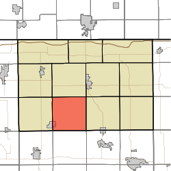
- Clearspring Township, LaGrange County, Indiana
-
Clearspring Township — Township — Coordinates: 41°34′09″N 85°28′58″W / 41.56917°N 85.48278°WCoordinates: 41°34′09″N 85°28′58″W / 41.56917°N 85.48278°W Country United States State Indiana County LaGrange Government – Type Indiana township Area – Total 35.98 sq mi (93.19 km2) – Land 35.65 sq mi (92.34 km2) – Water 0.33 sq mi (0.86 km2) Elevation[1] 925 ft (282 m) Population (2000) – Total 4,005 – Density 112.34/sq mi (43.37/km2) FIPS code 18-13456[2] GNIS feature ID 453224 Clearspring Township is one of eleven townships in LaGrange County, Indiana. As of the 2000 census, its population was 4,005.
References
- ^ "US Board on Geographic Names". United States Geological Survey. 2007-10-25. http://geonames.usgs.gov. Retrieved 2008-01-31.
- ^ "American FactFinder". United States Census Bureau. http://factfinder.census.gov. Retrieved 2008-01-31.
External links
Municipalities and communities of LaGrange County, Indiana Towns LaGrange | Shipshewana | Topeka | Wolcottville‡
Townships Bloomfield | Clay | Clearspring | Eden | Greenfield | Johnson | Lima | Milford | Newbury | Springfield | Van Buren
Unincorporated
communitiesBeatys Beach | Brighton | Brushy Prairie | Eddy | Elmira | Emma | Gravel Beach | Greenfield Mills | Greenwood | Hartzel | Honeyville | Howe | Indianola | Lakeview | Mongo | Mount Pisgah | Ontario | Plato | Ramblewood | Scott | Seyberts | Shady Nook | South Milford | Star Mill | Stony Creek | Stroh | Timberhurst | Valentine | Webers Landing | Witmer Manor | Woodland Park | Woodruff
Footnotes ‡This populated place also has portions in an adjacent county or counties
Categories:- Townships in LaGrange County, Indiana
- Northern Indiana geography stubs
Wikimedia Foundation. 2010.

