- National Register of Historic Places listings in Greenville County, South Carolina
-
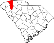
 Location of Greenville County in South Carolina
This is a list of the National Register of Historic Places listings in Greenville County, South Carolina.
This is intended to be a complete list of the properties and districts on the National Register of Historic Places in Greenville County, South Carolina, United States. The locations of National Register properties and districts for which the latitude and longitude coordinates are included below, may be seen in a map.[1]
There are 69 properties and districts listed on the National Register in the county. The city of Greenville is the location of 39 of these properties and districts; they are listed separately, while the 30 properties and districts in the remaining parts of the county are listed here. Another property in Greenville County outside of Greenville was once listed but has been removed.
-
- This National Park Service list is complete through NPS recent listings posted November 10, 2011.[2]
Current listings
[3] Landmark name[4] Image Date listed Location City or Town Summary 1 Arthur Barnwell House March 19, 1982 South of Greer on South Carolina Highway 14
34°51′18″N 82°13′41″W / 34.855°N 82.22806°WGreer 2 William Bates House December 4, 1978 East of Greenville on South Carolina Highway 14
34°50′53″N 82°14′4″W / 34.84806°N 82.23444°WGreenville 3 Burdette Building July 17, 2003 104 E. Curtis St.
34°44′14″N 82°15′19″W / 34.73722°N 82.25528°WSimpsonville 4 Campbell's Covered Bridge July 1, 2009 123 Campbell Covered Bridge Rd.
35°5′9″N 82°15′51″W / 35.08583°N 82.26417°WGowensville 5 Cannon Building September 28, 2005 100 N. Main St.
34°41′37″N 82°11′59″W / 34.69361°N 82.19972°WFountain Inn 6 Cureton-Huff House January 13, 1983 Southwest of Simpsonville off South Carolina Highway 176
34°41′34″N 82°20′2″W / 34.69278°N 82.33389°WSimpsonville 7 Davenport House February 1, 1999 100 Randall St.
34°56′10″N 82°13′37″W / 34.93611°N 82.22694°WGreer 8 Fairview Presbyterian Church August 16, 1977 West of Fountain Inn off South Carolina Highway 418
34°38′37″N 82°15′5″W / 34.64361°N 82.25139°WFountain Inn 9 Fountain Inn High School June 3, 2009 315 N. Main St.
34°41′43.83″N 82°12′5.91″W / 34.6955083°N 82.2016417°WFountain Inn 10 Fountain Inn Principal's House and Teacherage June 27, 2011 105 Mt. Zion Dr.
34°41′47″N 82°11′33″W / 34.69639°N 82.1925°WFountain Inn 11 Gilreath's Mill May 28, 1976 4 miles northwest of Greer on South Carolina Highway 101
34°58′23″N 82°16′44″W / 34.97306°N 82.27889°WGreer 12 John H. Goodwin House September 8, 1983 South Carolina Highway 11 at U.S. Route 25
35°5′19″N 82°27′8″W / 35.08861°N 82.45222°WTravelers Rest 13 Greer Depot March 6, 1987 311 Trade St.
34°56′10″N 82°13′33″W / 34.93611°N 82.22583°WGreer 14 Greer Downtown Historic District September 18, 1997 Roughly bounded by Trade, E. Poinsett, Randall, Victoria, and N. Main Sts.
34°56′16″N 82°13′43″W / 34.93778°N 82.22861°WGreer 15 Greer Post Office January 31, 2011 106 S Main St.
34°56′18.7″N 82°13′37.6″W / 34.938528°N 82.227111°WGreer 16 Hopkins Farm September 20, 2007 3717 Fork Shoals Rd.
34°38′53.05″N 82°18′29.62″W / 34.6480694°N 82.3082278°WSimpsonville 17 Louie James House September 19, 1996 401 W. Poinsett St.
34°56′25″N 82°14′5″W / 34.94028°N 82.23472°WGreer 18 McBee Methodist Church 
March 23, 1972 Main St.
34°46′0″N 82°21′10″W / 34.766667°N 82.35278°WConestee 19 McDowell House November 17, 2010 500 N Main St.
34°41′53″N 82°12′17″W / 34.69806°N 82.20472°WFountain Inn 20 Monaghan Mill October 4, 2005 201 Smythe St.
34°52′0″N 82°25′27″W / 34.866667°N 82.42417°WCity View 21 Paris Mountain State Park Historic District 
April 30, 1998 2401 State Park Rd.
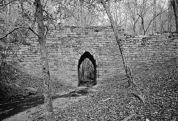
34°56′25″N 82°23′39″W / 34.94028°N 82.39417°WGreenville 22 Pelham Mills Site (38GR165) November 19, 1987 Address Restricted Pelham 23 Poinsett Bridge 
October 22, 1970 About 4 miles north of Tigerville on County Road 42
35°7′47″N 82°23′6″W / 35.12972°N 82.385°WTigerville 24 George Salmon House January 21, 1988 South Carolina Highway 414, 1.8 miles west of U.S. Route 25
35°2′7″N 82°27′31″W / 35.03528°N 82.45861°WTravelers Rest 25 Simpsonville Baptist Church October 13, 1992 106 Church St.
34°44′21″N 82°15′10″W / 34.73917°N 82.25278°WSimpsonville 26 Tullyton July 31, 1990 606 Hickory Tavern Rd.
34°36′24″N 82°13′57″W / 34.60667°N 82.2325°WFountain Inn 27 R. Perry Turner House February 1, 1999 211 N. Main St.
34°56′29″N 82°13′31″W / 34.94139°N 82.22528°WGreer 28 Robert G. Turner House February 1, 1999 305 N. Main St.
34°56′34″N 82°13′30″W / 34.94278°N 82.225°WGreer 29 F. W. Welborn House November 23, 2010 405 N. Weston St.
34°41′51″N 82°12′9″W / 34.6975°N 82.2025°WFountain Inn 30 Woodside Cotton Mill Village Historic District April 30, 1987 Woodside Ave. and E. Main St.
34°51′12″N 82°25′47″W / 34.85333°N 82.42972°WWoodside Former listing
Landmark name Image Dates Location City or Town Summary 1 Piedmont Number One 
March 5, 1986 (delisted) Main Street Piedmont Burned in 1983. See also
- List of National Historic Landmarks in South Carolina
- National Register of Historic Places listings in South Carolina
References
- ^ The latitude and longitude information provided in this table was derived originally from the National Register Information System, which has been found to be fairly accurate for about 99% of listings. For about 1% of NRIS original coordinates, experience has shown that one or both coordinates are typos or otherwise extremely far off; some corrections may have been made. A more subtle problem causes many locations to be off by up to 150 yards, depending on location in the country: most NRIS coordinates were derived from tracing out latitude and longitudes off of USGS topographical quadrant maps created under the North American Datum of 1927, which differs from the current, highly accurate WGS84 GPS system used by Google maps. Chicago is about right, but NRIS longitudes in Washington are higher by about 4.5 seconds, and are lower by about 2.0 seconds in Maine. Latitudes differ by about 1.0 second in Florida. Some locations in this table may have been corrected to current GPS standards.
- ^ "National Register of Historic Places: Weekly List Actions". National Park Service, United States Department of the Interior. Retrieved on November 10, 2011.
- ^ Numbers represent an ordering by significant words. Various colorings, defined here, differentiate National Historic Landmark sites and National Register of Historic Places Districts from other NRHP buildings, structures, sites or objects.
- ^ "National Register Information System". National Register of Historic Places. National Park Service. 2009-03-13. http://nrhp.focus.nps.gov/natreg/docs/All_Data.html.
U.S. National Register of Historic Places in South Carolina Lists by county Abbeville • Aiken • Allendale • Anderson • Bamberg • Barnwell • Beaufort • Berkeley • Calhoun • Charleston • Cherokee • Chester • Chesterfield • Clarendon • Colleton • Darlington • Dillon • Dorchester • Edgefield • Fairfield • Florence • Georgetown • Greenville • Greenwood • Hampton • Horry • Jasper • Kershaw • Lancaster • Laurens • Lee • Lexington • Marion • Marlboro • McCormick • Newberry • Oconee • Orangeburg • Pickens • Richland • Saluda • Spartanburg • Sumter • Union • Williamsburg • York

Lists by city Other lists Municipalities and communities of Greenville County, South Carolina Cities Fountain Inn‡ | Greenville | Greer‡ | Mauldin | Simpsonville | Travelers Rest
CDPs Berea | City View | Dunean | Five Forks | Gantt | Golden Grove | Judson | Parker | Piedmont‡ | Sans Souci | Slater-Marietta | Tigerville | Taylors | Wade Hampton | Ware Place | Welcome
Footnotes ‡This populated place also has portions in an adjacent county or counties
Categories:- Greenville County, South Carolina
- National Register of Historic Places in South Carolina by county
-


Wikimedia Foundation. 2010.