- McBee Methodist Church
-
McBee Methodist Church
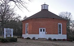 McBee Methodist Church in 2010
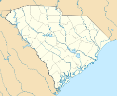

Location: Conestee, South Carolina Coordinates: 34°46′0″N 82°21′10″W / 34.766667°N 82.35278°WCoordinates: 34°46′0″N 82°21′10″W / 34.766667°N 82.35278°W Built: 1842 Architect: John Adams Architectural style: Octagon Mode Governing body: Private NRHP Reference#: 72001212[1] Added to NRHP: March 23, 1972 McBee Methodist Church, also known as McBee Chapel, is an historic octagonal-shaped yellow brick Methodist church building located on Main street in Conestee, Greenville County, South Carolina. Built in 1842, it was designed by wheelwright John Adams and named for Vardry McBee (1775-1864), the "Father of Greenville," who gave the money to build it.[2][3]
On March 23, 1972, it was added to the National Register of Historic Places.[1]
References
- ^ a b "National Register Information System". National Register of Historic Places. National Park Service. 2008-04-15. http://nrhp.focus.nps.gov/natreg/docs/All_Data.html.
- ^ South Carolina Department of History and Archives page on McBee Methodist Church
- ^ University of North Carolina Library: Inventory of the McBee Family Papers, 1754-1937
External links
- Waymarking page for McBee Chapel
- McBee Chapel Historical Marker
- McBee Chapel in Braymer Missouri started by family members
U.S. National Register of Historic Places in South Carolina Lists by county Abbeville • Aiken • Allendale • Anderson • Bamberg • Barnwell • Beaufort • Berkeley • Calhoun • Charleston • Cherokee • Chester • Chesterfield • Clarendon • Colleton • Darlington • Dillon • Dorchester • Edgefield • Fairfield • Florence • Georgetown • Greenville • Greenwood • Hampton • Horry • Jasper • Kershaw • Lancaster • Laurens • Lee • Lexington • Marion • Marlboro • McCormick • Newberry • Oconee • Orangeburg • Pickens • Richland • Saluda • Spartanburg • Sumter • Union • Williamsburg • York

Lists by city Other lists Keeper of the Register • History of the National Register of Historic Places • Property types • Historic district • Contributing property Categories:- Properties of religious function on the National Register of Historic Places in South Carolina
- Octagonal religious buildings in the United States
- Greenville County, South Carolina
- Methodist churches in South Carolina
- National Register of Historic Places in Greenville County, South Carolina
- South Carolina Registered Historic Place stubs


Wikimedia Foundation. 2010.