- National Register of Historic Places listings in Calhoun County, South Carolina
-
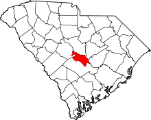 Location of Calhoun County in South Carolina
This is a list of the National Register of Historic Places listings in Calhoun County, South Carolina.
This is intended to be a complete list of the properties on the National Register of Historic Places in Calhoun County, South Carolina, United States. The locations of National Register properties for which the latitude and longitude coordinates are included below, may be seen in a Google map.[1]
There are 16 properties listed on the National Register in the county.
-
- This National Park Service list is complete through NPS recent listings posted November 10, 2011.[2]
Current listings
[3] Landmark name [4] Image Date listed Location City or town Summary 1 William Baker House March 8, 1978 East of Gaston off U.S. Route 21
33°49′50″N 80°59′46″W / 33.830556°N 80.996111°WGaston 2 Col. J.A. Banks House 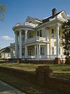
November 24, 1980 104 Dantzler St.
33°39′45″N 80°46′42″W / 33.6625°N 80.778333°WSt. Matthews 3 Buyck's Bluff Archeological Site May 4, 1979 Address Restricted St. Matthews 4 Calhoun County Courthouse October 30, 1981 S. Railroad Ave.
33°39′47″N 80°46′46″W / 33.663056°N 80.779444°WSt. Matthews 5 Calhoun County Library May 29, 1975 Railroad Ave.
33°40′01″N 80°46′28″W / 33.666944°N 80.774444°WSt. Matthews 6 Cherokee Path, Sterling Land Grant May 13, 1976 5 miles southeast of St. Matthews on South Carolina Highway 6
33°38′11″N 80°42′28″W / 33.636389°N 80.707778°WSt. Matthews 7 Col. Olin M. Dantzler House March 30, 1973 412 E. Bridge St. St. Matthews 8 Fort Motte Battle Site November 9, 1972 Address Restricted Fort Motte 9 Haigler House October 12, 2001 Winding Brook Dr. Cameron 10 David Houser House November 25, 1980 West of St. Matthews on U.S. Route 176
33°40′37″N 80°50′08″W / 33.676944°N 80.835556°WSt. Matthews 11 Midway Plantation May 28, 1976 South of Fort Motte off U.S. Route 601
33°40′31″N 80°41′39″W / 33.675278°N 80.694167°WFort Motte 12 Oakland Plantation May 30, 1975 South of Fort Motte
33°41′12″N 80°40′00″W / 33.686667°N 80.666667°WFort Motte 13 Prehistoric Indian Village July 30, 1974 Address Restricted St. Matthews 14 Puritan Farm July 25, 1974 West of St. Matthews
33°39′48″N 80°48′56″W / 33.663333°N 80.815556°WSt. Matthews 15 Ulmer-Summers House October 25, 1973 Old Orangeburg Rd. (South Carolina Highway 31)
33°33′44″N 80°42′55″W / 33.562222°N 80.715278°WCameron 16 Zante Plantation June 29, 1976 Southeast of Fort Motte off South Carolina Highway 601
33°42′37″N 80°38′32″W / 33.710278°N 80.642222°WFort Motte See also
- List of National Historic Landmarks in South Carolina
- National Register of Historic Places listings in South Carolina
References
- ^ The latitude and longitude information provided in this table was derived originally from the National Register Information System, which has been found to be fairly accurate for about 99% of listings. For about 1% of NRIS original coordinates, experience has shown that one or both coordinates are typos or otherwise extremely far off; some corrections may have been made. A more subtle problem causes many locations to be off by up to 150 yards, depending on location in the country: most NRIS coordinates were derived from tracing out latitude and longitudes off of USGS topographical quadrant maps created under the North American Datum of 1927, which differs from the current, highly accurate WGS84 GPS system used by Google maps. Chicago is about right, but NRIS longitudes in Washington are higher by about 4.5 seconds, and are lower by about 2.0 seconds in Maine. Latitudes differ by about 1.0 second in Florida. Some locations in this table may have been corrected to current GPS standards.
- ^ "National Register of Historic Places: Weekly List Actions". National Park Service, United States Department of the Interior. Retrieved on November 10, 2011.
- ^ Numbers represent an ordering by significant words. Various colorings, defined here, differentiate National Historic Landmark sites and National Register of Historic Places Districts from other NRHP buildings, structures, sites or objects.
- ^ "National Register Information System". National Register of Historic Places. National Park Service. . http://nrhp.focus.nps.gov/natreg/docs/All_Data.html.
U.S. National Register of Historic Places in South Carolina Lists by county Abbeville • Aiken • Allendale • Anderson • Bamberg • Barnwell • Beaufort • Berkeley • Calhoun • Charleston • Cherokee • Chester • Chesterfield • Clarendon • Colleton • Darlington • Dillon • Dorchester • Edgefield • Fairfield • Florence • Georgetown • Greenville • Greenwood • Hampton • Horry • Jasper • Kershaw • Lancaster • Laurens • Lee • Lexington • Marion • Marlboro • McCormick • Newberry • Oconee • Orangeburg • Pickens • Richland • Saluda • Spartanburg • Sumter • Union • Williamsburg • York

Lists by city Other lists Municipalities and communities of Calhoun County, South Carolina Towns 
Unincorporated
communitiesLone Star | Sandy Run
Categories:- Calhoun County, South Carolina
- National Register of Historic Places in South Carolina by county
- Buildings and structures in Calhoun County, South Carolina
-


Wikimedia Foundation. 2010.