- National Register of Historic Places listings in Lexington County, South Carolina
-
 Location of Lexington County in South Carolina
This is a list of the National Register of Historic Places listings in Lexington County, South Carolina.
This is intended to be a complete list of the properties and districts on the National Register of Historic Places in Lexington County, South Carolina, United States. The locations of National Register properties and districts for which the latitude and longitude coordinates are included below, may be seen in a Google map.[1]
There are 58 properties and districts listed on the National Register in the county. Another 2 properties were once listed but have been removed.
-
- This National Park Service list is complete through NPS recent listings posted November 10, 2011.[2]
Current listings
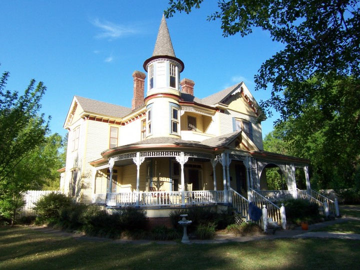
[3] Landmark name [4] Image Date listed Location City or town Summary 1 Ballentine-Shealy House November 22, 1983 South Carolina Highway 1323
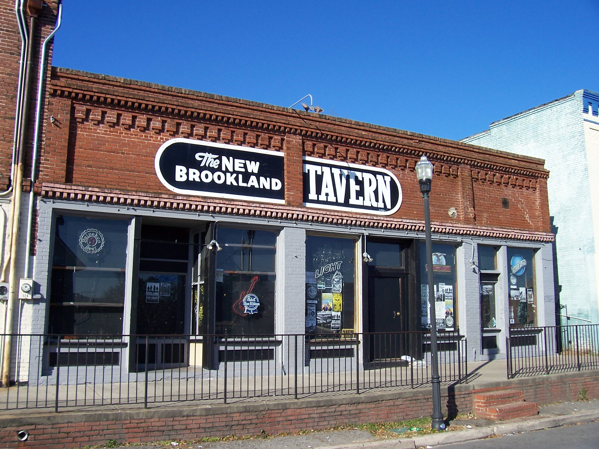
34°06′17″N 81°22′55″W / 34.104722°N 81.381944°WLexington 2 Bank of Western Carolina November 22, 1983 126 Main St.
33°58′53″N 81°14′12″W / 33.981389°N 81.236667°WLexington 3 D. D. D. Barr House November 22, 1983 Off South Carolina Highway 245
33°56′12″N 81°31′38″W / 33.936667°N 81.527222°WBatesburg-Leesville 4 Batesburg Commercial Historic District July 6, 1982 Granite, Oak, Pine, and Church Sts., and Rutland and N. Railroad Aves.
33°54′25″N 81°32′54″W / 33.906944°N 81.548333°WBatesburg-Leesville 5 W. Q. M. Berly House November 22, 1983 122 Berly St.
33°59′14″N 81°14′30″W / 33.987222°N 81.241667°WLexington 6 William Berly House November 23, 1977 121 Berly St.
33°59′14″N 81°14′29″W / 33.987222°N 81.241389°WLexington 7 Lemuel Boozer House August 16, 1977 320 W. Main St.
33°59′06″N 81°14′32″W / 33.985°N 81.242222°WLexington 8 Simon Bouknight House July 6, 1982 Saluda Ave.
33°54′32″N 81°33′10″W / 33.908889°N 81.552778°WBatesburg-Leesville 9 Cartledge House July 6, 1982 305 Saluda Ave.
33°54′31″N 81°33′08″W / 33.908611°N 81.552222°WBatesburg-Leesville 10 William J. Cayce House April 16, 1975 517 Holland Ave.
33°58′31″N 81°03′13″W / 33.975278°N 81.053611°WCayce 11 Cedar Grove Lutheran Church November 17, 2010 1220 Cedar Grove Rd.
33°59′13″N 81°27′35″W / 33.986944°N 81.459722°WLeesville 12 Church Street Historic District July 6, 1982 Church St.
33°55′09″N 81°30′24″W / 33.919167°N 81.506667°WBatesburg-Leesville 13 "Congarees" Site December 31, 1974 Address Restricted Cayce 14 C.E. Corley House November 22, 1983 808 S. Lake Dr.
33°58′00″N 81°14′02″W / 33.966667°N 81.233889°WLexington 15 Jacob Wingard Dreher House November 22, 1983 Off South Carolina Highway 6
34°04′13″N 81°14′27″W / 34.070278°N 81.240833°WIrmo 16 Broadus Edwards House July 6, 1982 12 Peachtree St.
33°54′12″N 81°33′03″W / 33.903333°N 81.550833°WBatesburg-Leesville 17 Fox House July 1, 1970 232 Fox St.
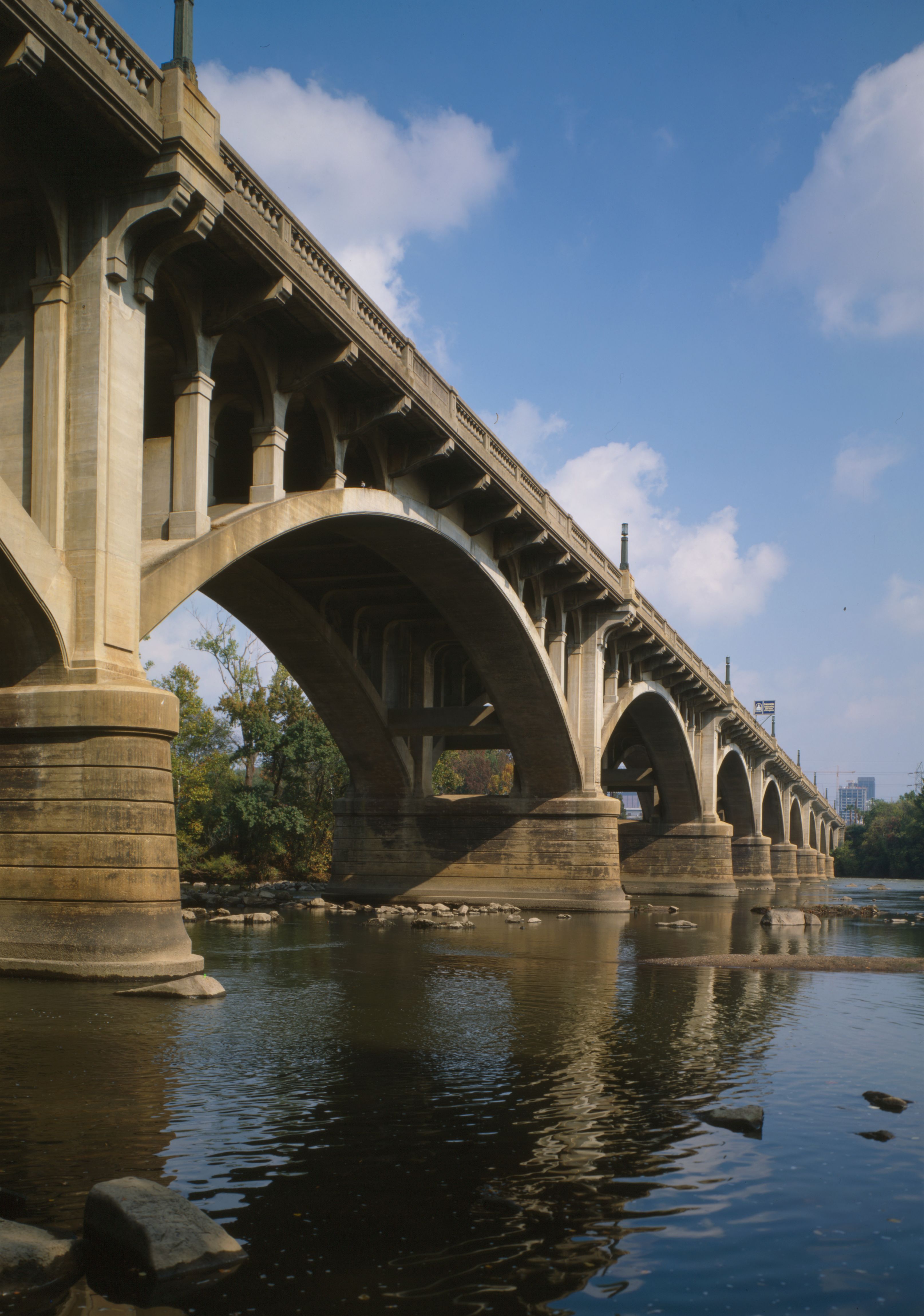
33°59′14″N 81°14′23″W / 33.987222°N 81.239722°WLexington 18 Gervais Street Bridge 
November 25, 1980 Spans the Congaree River
33°59′47″N 81°02′55″W / 33.996389°N 81.048611°WWest Columbia Extends into Columbia in Richland County 19 David Jefferson Griffith House November 22, 1983 Address Restricted Gilbert 20 Guignard Brick Works February 13, 1995 100 Granby Crossing at Knox Abbot Dr.
33°59′16″N 81°03′02″W / 33.987778°N 81.050556°WCayce 21 Gunter-Summers House November 10, 1987 841 Center St.
33°59′24″N 81°04′00″W / 33.99°N 81.066667°WLexington 22 Hampton Hendrix Office July 6, 1982 Leesville Ave.
33°55′05″N 81°30′50″W / 33.918056°N 81.513889°WBatesburg-Leesville 23 James Harman Building November 22, 1983 Gantt St.
33°58′55″N 81°14′09″W / 33.981944°N 81.235833°WLexington 24 Hartley House July 9, 1982 305 E. Columbia Ave.
33°54′23″N 81°32′27″W / 33.906389°N 81.540833°WBatesburg-Leesville 25 Ernest L. Hazelius House May 11, 1973 Fox St.
33°59′14″N 81°14′26″W / 33.987222°N 81.240556°WLexington 26 Henry Franklin Hendrix House July 6, 1982 Hendrix Heights Plantation
33°54′56″N 81°31′33″W / 33.915556°N 81.525833°WBatesburg-Leesville 27 John Solomon Hendrix House November 22, 1983 Old Cherokee Rd.
34°00′14″N 81°17′09″W / 34.003889°N 81.285833°WLexington 28 Thomas Galbraith Herbert House July 6, 1982 506 Trotter St.
33°55′32″N 81°31′05″W / 33.925556°N 81.518056°WBatesburg-Leesville 29 John Jacob Hite Farm November 22, 1983 Address Restricted Lexington 30 J.B. Holman House July 6, 1982 N. Peachtree St.
33°54′18″N 81°33′07″W / 33.905°N 81.551944°WBatesburg-Leesville 31 Home National Bank November 22, 1983 Main St. and North Lake Dr.
33°58′52″N 81°14′09″W / 33.981111°N 81.235833°WLexington 32 A.C. Jones House July 6, 1982 104 Fair Ave.
33°54′22″N 81°32′33″W / 33.906111°N 81.5425°WBatesburg-Leesville 33 Leesville College Historic District July 6, 1982 Railroad Ave. and College, Peachtree, King, and Lee Sts.
33°55′14″N 81°30′55″W / 33.920556°N 81.515278°WBatesburg-Leesville 34 Henry Lybrand Farm November 22, 1983 Address Restricted Lexington 35 Manning Archeological Site December 14, 1978 Address Restricted Cayce 36 Maj. Henry A. Meetze House July 13, 1979 South of Lexington at 723 S. Lake Dr.
33°58′06″N 81°14′04″W / 33.968333°N 81.234444°WLexington 37 Crowell Mitchell House July 6, 1982 Church St.
33°55′02″N 81°30′40″W / 33.917222°N 81.511111°WBatesburg-Leesville 38 McKendree Mitchell House July 6, 1982 310 Saluda Ave.
33°54′35″N 81°33′09″W / 33.909722°N 81.5525°WBatesburg-Leesville 39 Mitchell-Shealy House July 6, 1982 419 W. Church St.
33°54′39″N 81°31′37″W / 33.910833°N 81.526944°WBatesburg-Leesville 40 Mount Hebron Temperance Hall November 24, 1980 3041 Leaphart Rd.
33°59′58″N 81°07′29″W / 33.999444°N 81.124722°WWest Columbia 41 Music Hall Evangelical Lutheran Church November 22, 1983 Address Restricted Gilbert 42 New Brookland Historic District 
October 10, 1978 Roughly bounded by Alexander Rd. and Augusta, State, Spring, and Meeting Sts.
33°59′34″N 81°03′17″W / 33.992778°N 81.054722°WWest Columbia 43 Old Batesburg Grade School May 27, 1983 306 E. Columbia Ave
33°54′23″N 81°32′23″W / 33.906389°N 81.539722°WBatesburg-Leesville 44 Old Batesburg-Leesville High School July 6, 1982 Summerland Ave.
33°54′39″N 81°32′24″W / 33.910833°N 81.54°WLexington 45 Charlton Rauch House November 22, 1983 Main and Cedar Sts.
33°59′03″N 81°14′26″W / 33.984167°N 81.240556°WLexington 46 David Rawl House November 22, 1983 201 W. Main St.
33°58′59″N 81°14′21″W / 33.983056°N 81.239167°WLexington 47 John Jacob Rawl House July 6, 1982 Line St.
33°54′33″N 81°32′53″W / 33.909167°N 81.548056°WBatesburg-Leesville 48 Rawl-Couch House 
July 6, 1982 22 Short St.
33°54′29″N 81°33′14″W / 33.908056°N 81.553889°WBatesburg-Leesville 49 Robinson-Hiller House May 18, 1998 113 Virginia St.
34°09′57″N 81°21′20″W / 34.165833°N 81.355556°WChapin 50 Saluda Factory Historic District May 25, 1973 Along the Saluda River southeast of the junction of Interstates 26 and 126
34°01′05″N 81°05′13″W / 34.018056°N 81.086944°WWest Columbia 51 SAM Site December 6, 1978 Address Restricted Cayce A South Appalachian Mississippian site 52 Simmons-Harth House November 22, 1983 102 Gantt St.
33°58′54″N 81°14′09″W / 33.981667°N 81.235833°WLexington 53 Southern Railway Depot May 27, 1983 Southeast corner of Perry and Wilson Sts.
33°54′22″N 81°32′33″W / 33.906111°N 81.5425°WBatesburg-Leesville 54 James Stewart House November 22, 1983 Address Restricted Lexington 55 Still Hopes November 22, 1983 Off 7th St.
33°59′08″N 81°03′44″W / 33.985556°N 81.062222°WCayce Also known as the G. A. Guignard House 56 Taylor Site November 21, 1974 Address Restricted Cayce 57 Vastine Wessinger House November 22, 1983 Address Restricted Lexington 58 Rev. Frank Yarborough House July 6, 1982 810 Bernard St.
33°55′30″N 81°30′57″W / 33.925°N 81.515833°WBatesburg-Leesville Former listings
Landmark name Image Date Location City or Town Summary 1 George's Grist and Flour Mill March 15, 2005 (delisted) Lexington It has burned. 2 Timmerman Law Office December 8, 2005 (delisted) Lexington It was moved. See also
- List of National Historic Landmarks in South Carolina
- National Register of Historic Places listings in South Carolina
References
- ^ The latitude and longitude information provided in this table was derived originally from the National Register Information System, which has been found to be fairly accurate for about 99% of listings. For about 1% of NRIS original coordinates, experience has shown that one or both coordinates are typos or otherwise extremely far off; some corrections may have been made. A more subtle problem causes many locations to be off by up to 150 yards, depending on location in the country: most NRIS coordinates were derived from tracing out latitude and longitudes off of USGS topographical quadrant maps created under North American Datum of 1927, which differs from the current, highly accurate GPS system used by Google maps. Chicago is about right, but NRIS longitudes in Washington are higher by about 4.5 seconds, and are lower by about 2.0 seconds in Maine. Latitudes differ by about 1.0 second in Florida. Some locations in this table may have been corrected to current GPS standards.
- ^ "National Register of Historic Places: Weekly List Actions". National Park Service, United States Department of the Interior. Retrieved on November 10, 2011.
- ^ Numbers represent an ordering by significant words. Various colorings, defined here, differentiate National Historic Landmark sites and National Register of Historic Places Districts from other NRHP buildings, structures, sites or objects.
- ^ "National Register Information System". National Register of Historic Places. National Park Service. . http://nrhp.focus.nps.gov/natreg/docs/All_Data.html.
U.S. National Register of Historic Places in South Carolina Lists by county Abbeville • Aiken • Allendale • Anderson • Bamberg • Barnwell • Beaufort • Berkeley • Calhoun • Charleston • Cherokee • Chester • Chesterfield • Clarendon • Colleton • Darlington • Dillon • Dorchester • Edgefield • Fairfield • Florence • Georgetown • Greenville • Greenwood • Hampton • Horry • Jasper • Kershaw • Lancaster • Laurens • Lee • Lexington • Marion • Marlboro • McCormick • Newberry • Oconee • Orangeburg • Pickens • Richland • Saluda • Spartanburg • Sumter • Union • Williamsburg • York

Lists by city Other lists Keeper of the Register • History of the National Register of Historic Places • Property types • Historic district • Contributing property Municipalities and communities of Lexington County, South Carolina County seat: Lexington Cities Cayce‡ | Columbia‡ | West Columbia
Towns Batesburg-Leesville‡ | Chapin | Gaston | Gilbert | Irmo‡ | Lexington | Pelion | Pine Ridge | South Congaree | Springdale | Summit | Swansea
CDPs Footnotes ‡This populated place also has portions in an adjacent county or counties
Categories:- Lexington County, South Carolina
- National Register of Historic Places in South Carolina by county
-


Wikimedia Foundation. 2010.