- National Register of Historic Places listings in Laurens County, South Carolina
-
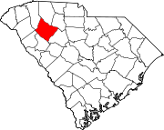
 Location of Laurens County in South Carolina
This is a list of the National Register of Historic Places listings in Laurens County, South Carolina.
This is intended to be a complete list of the properties and districts on the National Register of Historic Places in Laurens County, South Carolina, United States. The locations of National Register properties and districts for which the latitude and longitude coordinates are included below, may be seen in a Google map.[1]
There are 25 properties and districts listed on the National Register in the county.
-
- This National Park Service list is complete through NPS recent listings posted November 10, 2011.[2]
Current listings
[3] Landmark name [4] Image Date listed Location City or town Summary 1 Albright-Dukes House November 19, 1986 127 Academy St.
34°29′25″N 82°01′05″W / 34.490278°N 82.018056°WLaurens 2 Charlton Hall Plantation House May 26, 1995 South Carolina Highway 101, approximately 2.5 miles south of Hickory Tavern
34°29′40″N 82°10′06″W / 34.494444°N 82.168333°WHickory Tavern 3 Clinton Commercial Historic District November 15, 1984 Main, Broad, Pitts, Musgrove and Gary Sts.
34°28′23″N 81°52′52″W / 34.473056°N 81.881111°WClinton 4 Lyde Irby Darlington House November 19, 1986 110 Irby Ave.
34°29′41″N 82°01′05″W / 34.494722°N 82.018056°WLaurens 5 Allen Dial House January 21, 1982 South Carolina Highway 729
34°28′36″N 82°06′05″W / 34.476667°N 82.101389°WLaurens 6 Charles H. Duckett House November 19, 1986 105 Downs St.
34°29′46″N 82°01′42″W / 34.496111°N 82.028333°WLaurens 7 Duncan's Creek Presbyterian Church November 15, 1973 5 miles northeast of Clinton, off South Carolina Highway 72
34°31′18″N 81°48′29″W / 34.521667°N 81.808056°WClinton 8 James Dunklin House October 1, 1974 544 W. Main St.
34°29′52″N 82°01′24″W / 34.497778°N 82.023333°WLaurens 9 Gray Court-Owings School April 21, 2004 9210 South Carolina Highway 14
34°37′11″N 82°07′23″W / 34.619722°N 82.123056°WGray Court 10 Dr. William Claudius Irby House November 19, 1986 132 Irby Ave.
34°29′38″N 82°01′06″W / 34.493889°N 82.018333°WLaurens 11 Irby-Henderson-Todd House September 8, 1983 112 Todd Ave.
34°29′28″N 82°01′52″W / 34.491111°N 82.031111°WLaurens 12 Laurens County Courthouse June 19, 1972 Laurens Courthouse Sq.
34°29′44″N 82°01′00″W / 34.495556°N 82.016667°WLaurens 13 Laurens Historic District October 10, 1980 U.S. Routes 76 and 221; also both sides of W. Main St. from 742 to 964 W. Main St.
34°29′51″N 82°01′12″W / 34.4975°N 82.02°WLaurens Second set of boundaries represents a boundary increase of November 19, 1986 14 Lindley's Fort Site November 7, 1978 Address Restricted Madens 15 Nickels-Milam House May 28, 1976 South of Laurens off U.S. Route 221
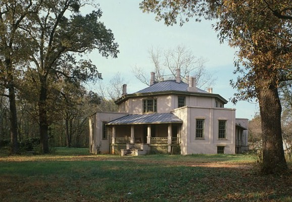
34°25′35″N 82°00′18″W / 34.426389°N 82.005°WLaurens 16 Octagon House 
March 20, 1973 619 E. Main St.
34°29′57″N 82°00′05″W / 34.499167°N 82.001389°WLaurens 17 John Calvin Owings House 
February 23, 1978 787 W. Main St.
34°29′38″N 82°01′43″W / 34.493889°N 82.028611°WLaurens Designed by architect George Franklin Barber 18 Rosemont Plantation June 11, 1993 Address Restricted Waterloo 19 William Dunlap Simpson House July 24, 1974 726 W. Main St.
34°29′44″N 82°01′30″W / 34.495556°N 82.025°WLaurens 20 Sitgreaves House November 19, 1986 428 W. Farley Ave.
34°29′23″N 82°01′42″W / 34.489722°N 82.028333°WLaurens 21 South Harper Historic District November 19, 1986 Both sides of S. Harper St. from 320 to 1037
34°29′31″N 82°00′59″W / 34.491944°N 82.016389°WLaurens 22 Sullivan House May 22, 1973 10 miles west of Laurens on U.S. Route 76
34°30′13″N 82°13′17″W / 34.503611°N 82.221389°WLaurens 23 Thornwell-Presbyterian College Historic District 
March 5, 1982 Presbyterian College Campus
34°27′58″N 81°52′48″W / 34.466111°N 81.88°WClinton 24 Williams-Ball-Copeland House November 19, 1986 544 Ball Dr.
34°30′01″N 82°01′30″W / 34.500278°N 82.025°WLaurens 25 Wilson-Clary House December 11, 1986 120 Irby Ave.
34°29′40″N 82°01′06″W / 34.494444°N 82.018333°WLaurens See also
- List of National Historic Landmarks in South Carolina
- National Register of Historic Places listings in South Carolina
References
- ^ The latitude and longitude information provided in this table was derived originally from the National Register Information System, which has been found to be fairly accurate for about 99% of listings. For about 1% of NRIS original coordinates, experience has shown that one or both coordinates are typos or otherwise extremely far off; some corrections may have been made. A more subtle problem causes many locations to be off by up to 150 yards, depending on location in the country: most NRIS coordinates were derived from tracing out latitude and longitudes off of USGS topographical quadrant maps created under North American Datum of 1927, which differs from the current, highly accurate GPS system used by Google maps. Chicago is about right, but NRIS longitudes in Washington are higher by about 4.5 seconds, and are lower by about 2.0 seconds in Maine. Latitudes differ by about 1.0 second in Florida. Some locations in this table may have been corrected to current GPS standards.
- ^ "National Register of Historic Places: Weekly List Actions". National Park Service, United States Department of the Interior. Retrieved on November 10, 2011.
- ^ Numbers represent an ordering by significant words. Various colorings, defined here, differentiate National Historic Landmark sites and National Register of Historic Places Districts from other NRHP buildings, structures, sites or objects.
- ^ "National Register Information System". National Register of Historic Places. National Park Service. . http://nrhp.focus.nps.gov/natreg/docs/All_Data.html.
U.S. National Register of Historic Places in South Carolina Lists by county Abbeville • Aiken • Allendale • Anderson • Bamberg • Barnwell • Beaufort • Berkeley • Calhoun • Charleston • Cherokee • Chester • Chesterfield • Clarendon • Colleton • Darlington • Dillon • Dorchester • Edgefield • Fairfield • Florence • Georgetown • Greenville • Greenwood • Hampton • Horry • Jasper • Kershaw • Lancaster • Laurens • Lee • Lexington • Marion • Marlboro • McCormick • Newberry • Oconee • Orangeburg • Pickens • Richland • Saluda • Spartanburg • Sumter • Union • Williamsburg • York

Lists by city Other lists Keeper of the Register • History of the National Register of Historic Places • Property types • Historic district • Contributing property Municipalities and communities of Laurens County, South Carolina County seat: Laurens Cities Clinton | Fountain Inn‡ | Laurens
Towns Cross Hill | Gray Court | Ware Shoals‡ | Waterloo
CDPs Joanna | Mountville | Princeton | Watts Mills
Unincorporated
communitiesHickory Tavern | Kinards‡
Footnotes ‡This populated place also has portions in an adjacent county or counties
Categories:- Laurens County, South Carolina
- National Register of Historic Places in South Carolina by county
-


Wikimedia Foundation. 2010.