- National Register of Historic Places listings in Greenwich, Connecticut
-
This is a list of the National Register of Historic Places listings in Greenwich, Connecticut.
This is intended to be a complete list of the properties and districts on the National Register of Historic Places in Greenwich. The locations of National Register properties and districts for which the latitude and longitude coordinates are included below, may be seen in a Google map.[1]
There are more than 250 properties and districts listed on the National Register in Fairfield County. This list covers the 33 or so properties that lie entirely in Greenwich or which span into Greenwich.
Current listings
[2] Landmark name[3] Image Date listed Location Summary 1 Bush-Holley House 
December 1, 1988 39 Strickland Rd., in Cos Cob[4]:2
41°2′17″N 73°35′41″W / 41.03806°N 73.59472°WHome of Cos Cob Art Colony, c.1890-1920. Current headquarters and museum of the Greenwich Historical Society. 2 Byram School August 2, 1990 Between Sherman Ave. and Western Junior Highway, in Byram[5]:3
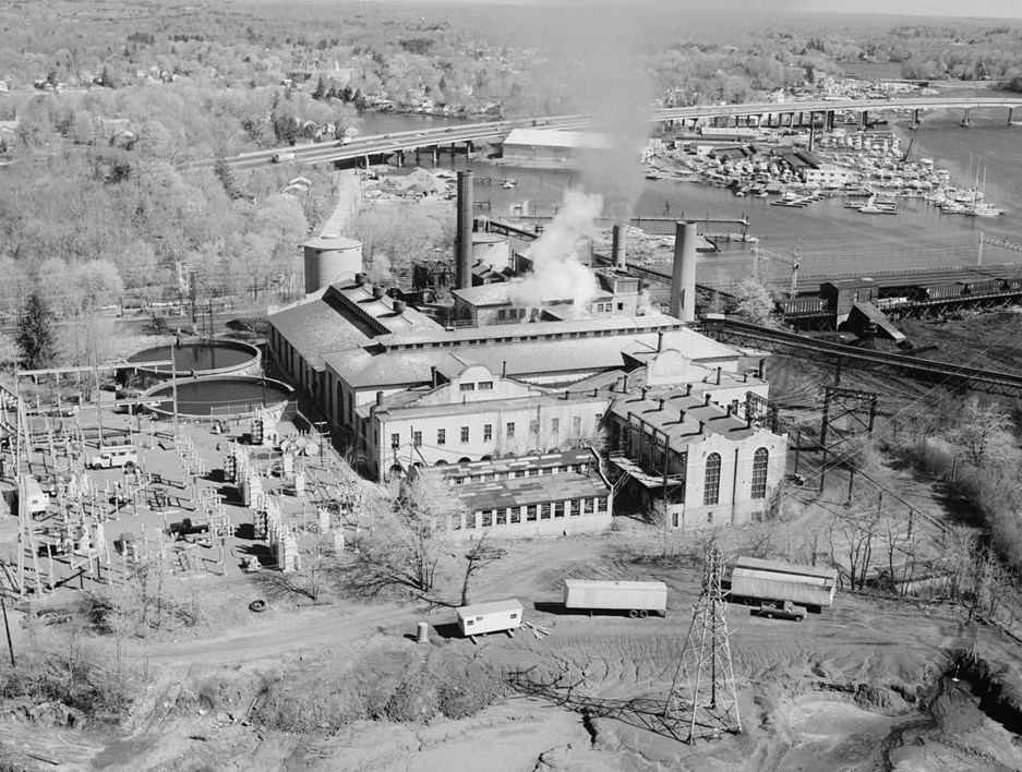
41°0′46″N 73°39′13″W / 41.01278°N 73.65361°W"Exceptional" for its architecture.[6] 3 Cos Cob Power Station 
August 2, 1990 Roughly bounded by Metro North railroad tracks, the Mianus River, and Sound Shore Dr.
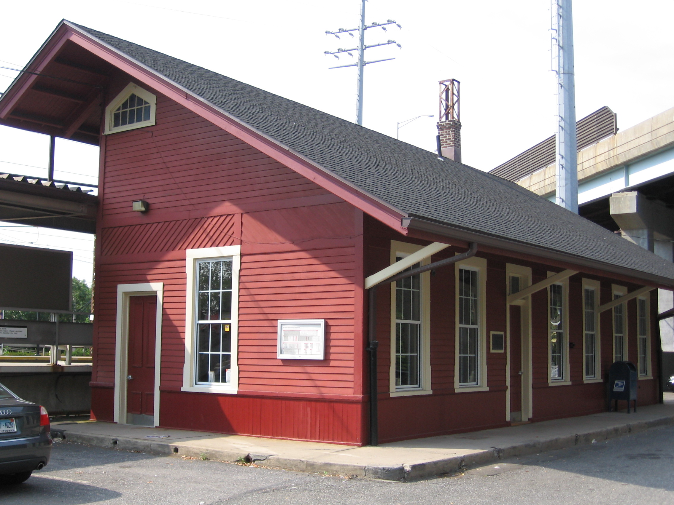
41°1′46″N 73°35′50″W / 41.02944°N 73.59722°WSignificant for its role in the first mainline railroad electrification in the United States. It was the largest component in an enormous scale experiment to implement AC power in railroad power, part of complying with a 1903 New York State law prohibiting steam locomotives in New York City.[7] 4 Cos Cob Railroad Station 
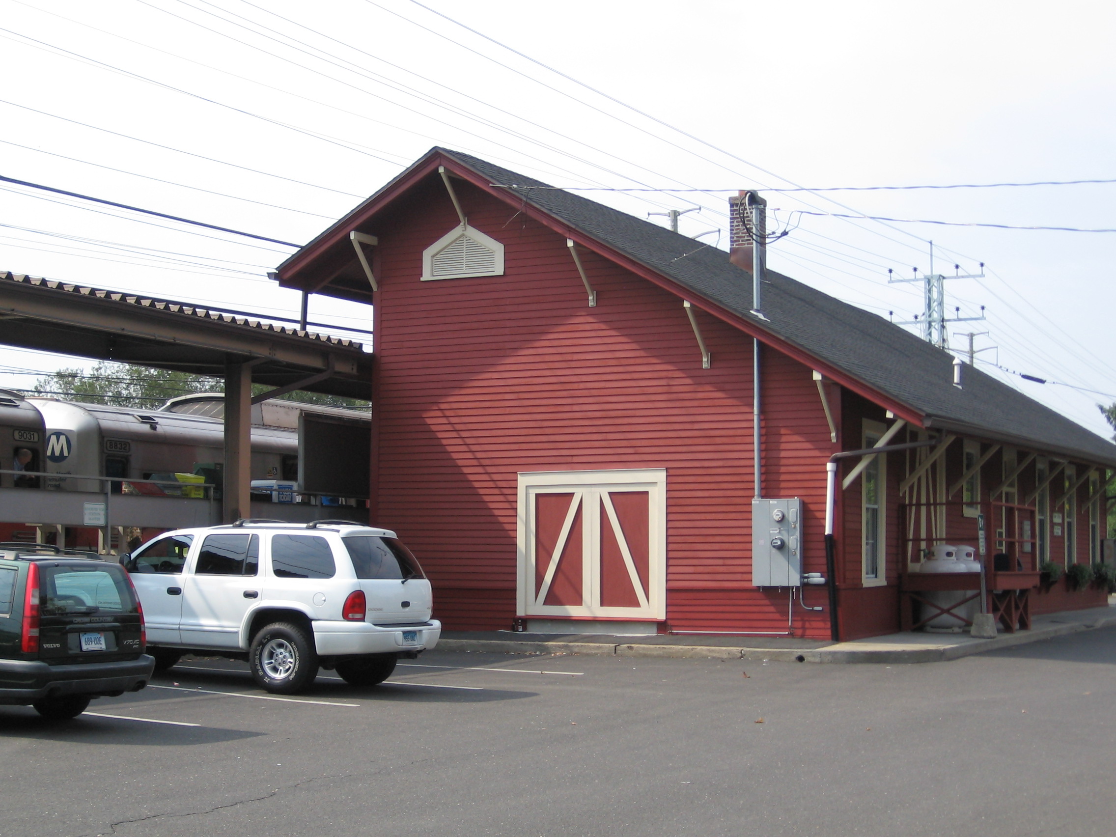
July 28, 1989 55 Station Dr.
41°1′47″N 73°36′2″W / 41.02972°N 73.60056°WA working train station 5 Samuel Ferris House August 10, 1989 E. Putnam and Cary Sts., in Riverside[8]:3
41°2′31.9″N 73°35′19.1″W / 41.042194°N 73.588639°W6 Fourth Ward Historic District April 21, 2000 Roughly along Church, Division, Northfield and William Sts.; and Putnam Court and Sherwood Place in downtown Greenwich
41°2′6″N 73°37′40″W / 41.035°N 73.62778°W7 French Farm April 3, 1975 North of downtown Greenwich at the junction of Lake Ave. and Round Hill Rd.
41°3′7″N 73°38′24″W / 41.05194°N 73.64°W8 Glenville Historic District March 9, 2007 Roughly along Glen Ridge Rd., Glenville Rd., Glenville St., Pemberwick Rd., Riversville Rd., and Weaver St.
41°2′17″N 73°39′53″W / 41.03806°N 73.66472°W[9]9 Glenville School 
November 21, 2003 449 Pemberwick Rd., in the Glenville Historic District[10]
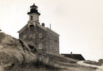
41°2′12″N 73°39′52″W / 41.03667°N 73.66444°W1921 school by James O. Betelle is only T-shaped Georgian Revival school in Greenwich. Now West Greenwich Civic Center. 10 Great Captain Island Lighthouse 
April 3, 1991 Great Captain Island, southwest of Greenwich Point
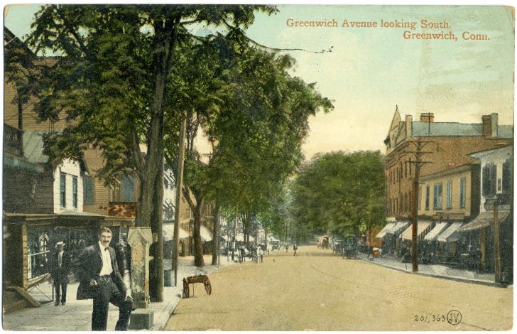
40°58′57″N 73°37′26″W / 40.9825°N 73.62389°W11 Greenwich Avenue Historic District 
August 31, 1989 Roughly bounded by Railroad, Arch, Field Point, W. Elm, Greenwich, Putnam, Mason, Havemeyer, and Bruce, in downtown Greenwich
41°1′33″N 73°37′36″W / 41.02583°N 73.62667°W12 Greenwich Municipal Center Historic District July 26, 1988 101 Field Point Rd., 290, 299, 310 Greenwich Ave., in downtown Greenwich
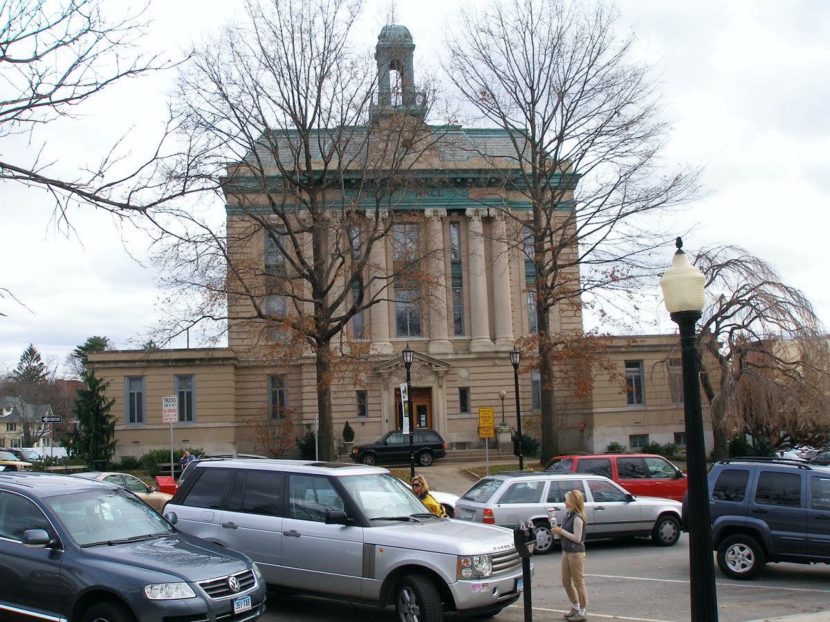
41°1′29″N 73°37′37″W / 41.02472°N 73.62694°W13 Greenwich Town Hall 
May 21, 1987 299 Greenwich Ave., in downtown Greenwich
41°1′30″N 73°37′32″W / 41.025°N 73.62556°W14 Greenwich YMCA November 7, 1996 50 E. Putnam Ave., in downtown Greenwich[11]:2
41°1′55″N 73°37′32″W / 41.03194°N 73.62556°W15 Indian Harbor Yacht Club 
July 22, 2010 710 Steamboat Rd.
41°0′42″N 73°37′22″W / 41.01167°N 73.62278°W16 Knapp Tavern 
September 15, 1977 243 E. Putnam Ave.
41°2′13″N 73°37′10″W / 41.03694°N 73.61944°W17 Little Bethel African Methodist Episcopal Church October 12, 2010 44 Lake Ave.
41°2′0″N 73°37′45″W / 41.033333°N 73.62917°W18 Thomas Lyon House August 24, 1977 W. Putnam Ave. and Byram Rd.
41°0′52″N 73°39′16″W / 41.01444°N 73.65444°W19 Merritt Parkway 
April 17, 1991 Route 15 right-of-way between the New York state line and the Sikorsky Memorial Bridge; also located in Stamford, New Canaan, Norwalk, Westport, Fairfield, Trumbull, and Stratford Historic parkway 20 Methodist Episcopal Church August 25, 1988 61 E. Putnam Ave.
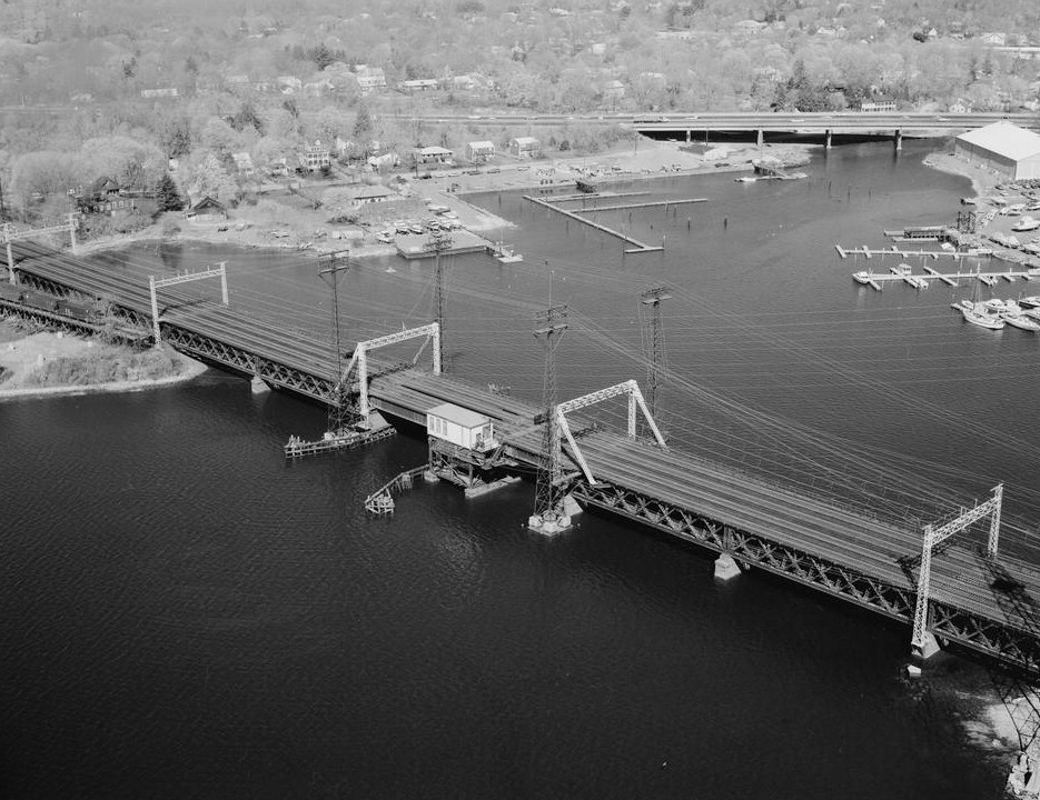
41°1′58″N 73°37′35″W / 41.03278°N 73.62639°W21 Mianus River Railroad Bridge 
June 12, 1987 Metro-North New Haven Line right-of-way at the Mianus River
41°1′51″N 73°35′41″W / 41.03083°N 73.59472°W22 Nathaniel Witherell Historic District June 9, 2010 70 Parsonage Rd.
41°3′41.43″N 73°37′36.92″W / 41.0615083°N 73.6269222°W23 New Mill and Depot Building, Hawthorne Woolen Mill 
February 23, 1990 350 Pemberwick Rd., in Glenville[12]
41°2′13″N 73°40′0″W / 41.03694°N 73.666667°W1875 mill and depot (accompanying railroad was never built) show unusually high style for functional buildings of that era. Now a retail/office complex. 24 Putnam Hill Historic District August 24, 1979 U.S. Route 1 between Maple Ave and Old Church Rd
41°2′11″N 73°37′9″W / 41.03639°N 73.61917°W25 Riverside Avenue Bridge 
August 29, 1977 Riverside Ave. and Metro-North New Haven Line railroad tracks
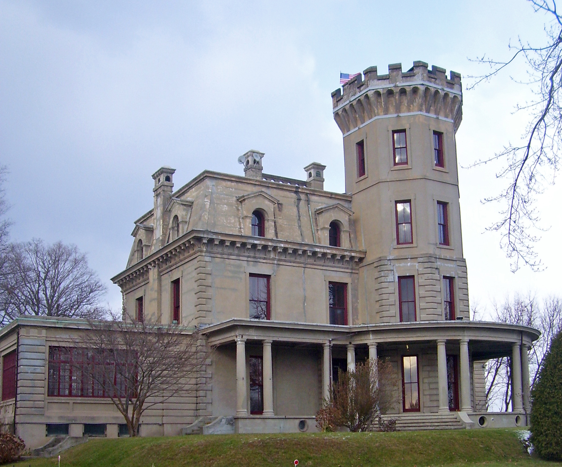
41°1′54″N 73°35′18″W / 41.03167°N 73.58833°W26 Rosemary Hall August 28, 1998 Junction of Ridgeway and Zaccheus Mead Ln. in the Rockridge neighborhood[13]:3
41°2′15″N 73°38′12″W / 41.0375°N 73.63667°W27 Round Hill Historic District July 25, 1996 Roughly the junction of John St. and Round Hill Rd., in the Back Country of Greenwich
41°5′44″N 73°40′10″W / 41.09556°N 73.66944°W28 Sylvanus Selleck Gristmill August 2, 1990 124 Old Mill Rd. in northern Greenwich[14]:10
41°5′31″N 73°39′33″W / 41.09194°N 73.65917°W29 Sound Beach Railroad Station 
July 28, 1989 160 Sound Beach Ave., in Old Greenwich
41°2′0″N 73°34′5″W / 41.033333°N 73.56806°WA working railroad station in the Old Greenwich (formerly called "Sound Beach") section of Greenwich 30 Strickland Road Historic District March 22, 1990 19-47 Strickland Rd. in Cos Cob[15]:2
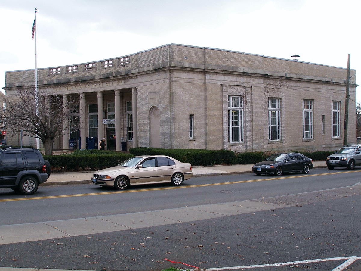
41°2′6″N 73°36′3″W / 41.035°N 73.60083°W31 US Post Office-Greenwich Main 
January 16, 1986 310 Greenwich Ave., in downtown Greenwich
41°1′26″N 73°37′33″W / 41.02389°N 73.62583°W32 William E. Ward House 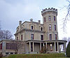
November 7, 1976 Comly Ave. in Glenville[16]
41°1′34″N 73°40′3″W / 41.02611°N 73.6675°WFirst reinforced concrete structure in U.S., built in 1870s on state line, and extending into Rye Brook, New York 33 Josiah Wilcox House November 30, 1988 354 Riversville Rd. in the Riversville neighborhood[17]:2
41°3′51.3″N 73°40′31.6″W / 41.06425°N 73.675444°WSee also
- National Register of Historic Places listings in Fairfield County, Connecticut
- National Register of Historic Places listings in Stamford, Connecticut
- National Register of Historic Places listings in Bridgeport, Connecticut
- List of National Historic Landmarks in Connecticut
References
- ^ The latitude and longitude information provided in this table was derived originally from the National Register Information System, which has been found to be fairly accurate for about 99% of listings. For about 1% of NRIS original coordinates, experience has shown that one or both coordinates are typos or otherwise extremely far off; some corrections may have been made. A more subtle problem causes many locations to be off by up to 150 yards, depending on location in the country: most NRIS coordinates were derived from tracing out latitude and longitudes off of USGS topographical quadrant maps created under the North American Datum of 1927, which differs from the current, highly accurate WGS84 GPS system used by Google maps. Chicago is about right, but NRIS longitudes in Washington are higher by about 4.5 seconds, and are lower by about 2.0 seconds in Maine. Latitudes differ by about 1.0 second in Florida. Some locations in this table may have been corrected to current GPS standards.
- ^ Numbers represent an ordering by significant words. Various colorings, defined here, differentiate National Historic Landmark sites and National Register of Historic Places Districts from other NRHP buildings, structures, sites or objects.
- ^ "National Register Information System". National Register of Historic Places. National Park Service. 2009-03-13. http://nrhp.focus.nps.gov/natreg/docs/All_Data.html.
- ^ [1]
- ^ [2]
- ^ Jan Cunningham (June 30, 1989). "National Register of Historic Places Inventory-Nomination: Byram School". National Park Service. http://pdfhost.focus.nps.gov/docs/NRHP/Text/90001110.pdf. and Accompanying eight photos, exterior and interior, from 1989 (see captions page 6 of text document)
- ^ Matthew Roth and Bruce Clouette (November 27, 1989). "National Register of Historic Places Registration: Cos Cob Power Station". National Park Service. http://pdfhost.focus.nps.gov/docs/NRHP/Text/90001096.pdf. and Accompanying 14 photos, exterior and interior, from 1989
- ^ [3]
- ^ Coordinates derived from Glenville Historic District page at livingpages.com
- ^ [4]
- ^ [5]
- ^ [6]
- ^ [7]
- ^ [8]
- ^ [9]
- ^ [10]
- ^ [11]
U.S. National Register of Historic Places Topics Lists by states Alabama • Alaska • Arizona • Arkansas • California • Colorado • Connecticut • Delaware • Florida • Georgia • Hawaii • Idaho • Illinois • Indiana • Iowa • Kansas • Kentucky • Louisiana • Maine • Maryland • Massachusetts • Michigan • Minnesota • Mississippi • Missouri • Montana • Nebraska • Nevada • New Hampshire • New Jersey • New Mexico • New York • North Carolina • North Dakota • Ohio • Oklahoma • Oregon • Pennsylvania • Rhode Island • South Carolina • South Dakota • Tennessee • Texas • Utah • Vermont • Virginia • Washington • West Virginia • Wisconsin • WyomingLists by territories Lists by associated states Other Categories:- Fairfield County, Connecticut
- National Register of Historic Places in Connecticut


Wikimedia Foundation. 2010.