- National Register of Historic Places listings in Southington, Connecticut
-
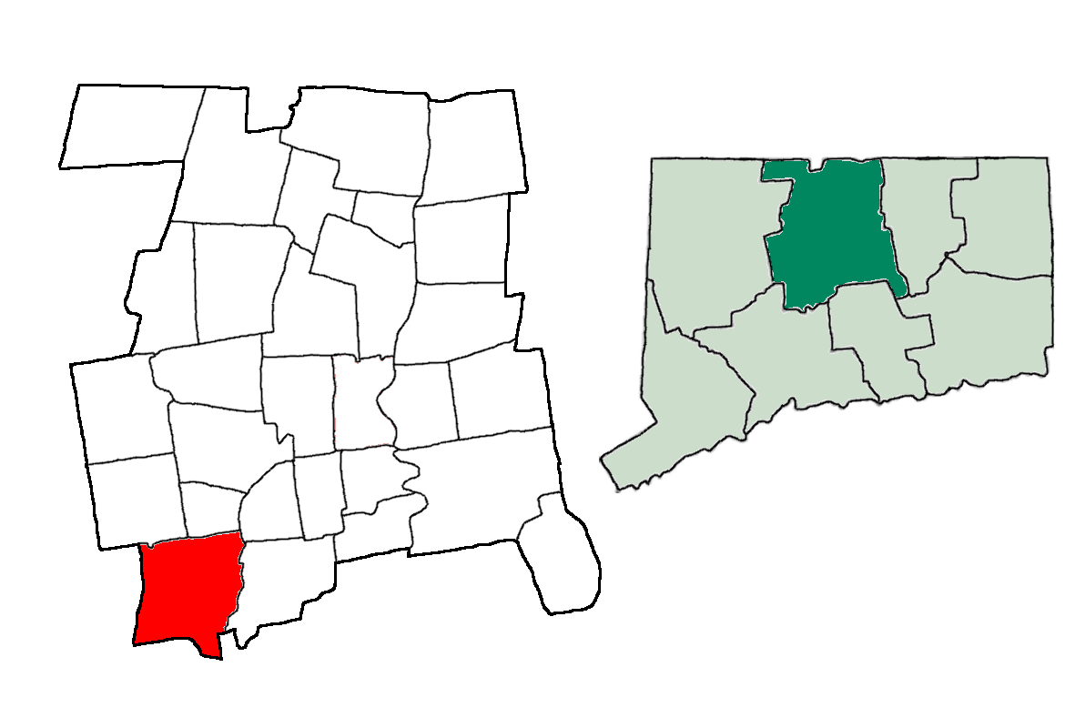
 Location of Southington in Connecticut
This is a list of the National Register of Historic Places listings in Southington, Connecticut.
This is intended to be a complete list of the properties and districts on the National Register of Historic Places in Southington, Connecticut, United States. The locations of National Register properties and districts for which the latitude and longitude coordinates are included below, may be seen in various online maps.[1]
There are 411 properties and districts listed on the National Register in Hartford County, including 20 National Historic Landmarks. The 40 properties and districts located in the town of Southington are listed below, while the 373 properties and districts in the remaining parts of the county are listed separately. The Farmington Canal-New Haven and Northampton Canal and the Marion Historic District extend into other communities in Hartford County and appear in both lists.
Twenty-five early houses in Southington were covered in a Multiple Property Submission study in 1988, and are indicated by asterisks (*) here.[2]
Contents: Counties in Connecticut Fairfield (city of Bridgeport) (town of Greenwich) (city of Stamford) | Hartford (city of Hartford) (town of Southington) (town of West Hartford) (town of Windsor) | Litchfield | Middlesex (city of Middletown) | New Haven (city of New Haven) | New London | Tolland | Windham
-
- This National Park Service list is complete through NPS recent listings posted November 10, 2011.[3]
Current listings
- Addresses are "Southington, CT" unless otherwise indicated.
[4] Landmark name[5] Image Date listed Location Summary 1 Luman Andrews House* 
January 19, 1989 469 Andrews St.
41°37′23″N 72°49′52″W / 41.62306°N 72.83111°WColonial house built in 1745; property is also important as location where volcanic rock suited for Portland cement was discovered.[6] 2 Atwater Manufacturing Company December 8, 1988 335 Atwater St., Plantsville, CT[7]
41°34′43″N 72°53′54″W / 41.57861°N 72.89833°W3 Selah Barnes House January 19, 1989 282 Prospect St., Plantsville, CT[8]
41°35′29″N 72°54′1″W / 41.59139°N 72.90028°W4 Barnes-Frost House* 
January 19, 1989 1177 Marion Ave., Marion, CT[9]
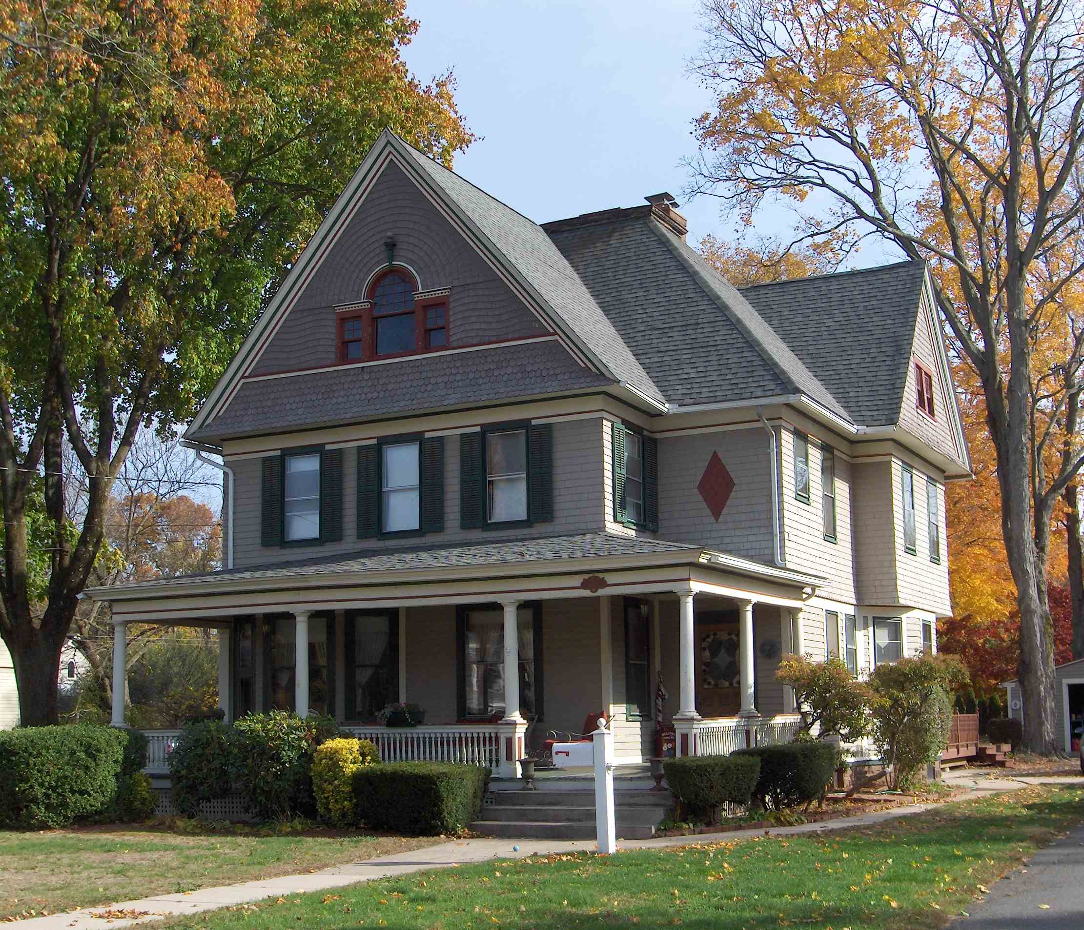
41°33′56″N 72°55′31″W / 41.56556°N 72.92528°WBuilt in 1795, significant in part as it is a preserved example of Colonial architecture, and also because it was home of the Barnes and Frost families.[10] The house shows a "high-style Federal embellishment", namely a "diamond and ellipse frieze band pattern".[11]:6 5 Blakeslee Forging Company December 8, 1988 100 W. Main St., Plantsville, CT[12]
41°34′38″N 72°53′36″W / 41.57722°N 72.89333°W6 Icabod Bradley House July 28, 1989 537 Shuttle Meadow Rd.
41°38′55″N 72°50′40″W / 41.64861°N 72.84444°W7 Clark Brothers Factory No. 1 December 8, 1988 1331 S. Main St., Milldale, CT[13]
41°34′3″N 72°54′10″W / 41.5675°N 72.90278°W8 Clark Brothers Factory No. 2 December 8, 1988 409 Canal St., Milldale, CT[14]
41°34′15″N 72°53′46″W / 41.57083°N 72.89611°W9 Avery Clark House January 19, 1989 1460 Meriden Ave.
41°33′48″N 72°51′12″W / 41.56333°N 72.85333°W10 Capt. Josiah Cowles House 
January 19, 1989 184 Marion Ave., Plantsville, CT[15]
41°35′5″N 72°54′12″W / 41.58472°N 72.90333°WResidence, c. 1750,[15] of an early settler, who was born in Farmington, Connecticut on November 20,1713.[16] Cowles was a justice of the peace and a captain in the local militia. He held a number of town offices, and was viewed as a leading man in town.[16] At the very first town meeting after the incorporation of Southington, held November 11,1779, the residents appointed Cowles, along with Jonathan Root to a committee to "provide for the families of officers and soldiers in the field."[17]:378 In 1774, Cowles was appointed to a committee to deliver provisions to Boston, in response to the British blockade of Boston harbor.[17]:180 11 Ebenezer Evans House January 19, 1989 17 Long Bottom Rd.
41°37′50″N 72°50′3″W / 41.63056°N 72.83417°W12 Farmington Canal-New Haven and Northampton Canal 
September 12, 1985 Roughly from Suffield in Hartford County to New Haven in New Haven County
41°35′59.7″N 72°53′0.5″W / 41.599917°N 72.883472°WFirst a canal, later a railroad, and now a multi-use trail. 13 Levi B. Frost House 
November 20, 1987 1089 Marion Ave., Marion, CT[18]
41°34′5″N 72°55′29″W / 41.56806°N 72.92472°W14 Stephen Grannis House January 19, 1989 1193 West St.
41°37′14″N 72°53′58″W / 41.62056°N 72.89944°W15 Timothy Hart House January 19, 1989 521 Flanders Rd.
41°37′9″N 72°50′43″W / 41.61917°N 72.84528°W16 House at 1010 Shuttle Meadow Road January 19, 1989 1010 Shuttle Meadow Rd.
41°38′58″N 72°51′12″W / 41.64944°N 72.85333°W17 House at 590 West Street January 19, 1989 590 West St.
41°36′16″N 72°53′57″W / 41.60444°N 72.89917°W18 Hurwood Company December 8, 1988 379 Summer St., Plantsville, CT[19]
41°35′22″N 72°53′26″W / 41.58944°N 72.89056°W19 Lake Compounce Carousel December 12, 1978 West of Southington Center on Lake Ave.
41°38′21″N 72°55′22″W / 41.63917°N 72.92278°W20 Marion Historic District 
December 21, 1988 Along Marion Ave. and Meriden-Waterbury Turnpike, in town of Southington and in town of Cheshire (in New Haven County)
41°33′50″N 72°55′29″W / 41.56389°N 72.92472°W21 Meriden Avenue-Oakland Road Historic District 
May 25, 1988 Roughly Oakland Rd. between Meriden and Berlin Aves., and Meriden Ave. between Oakland Rd. and Delhunty Dr.
41°35′31″N 72°52′26″W / 41.59194°N 72.87389°W22 Roswell Moore II House July 1, 2005 1166 Andrews St.
41°36′18″N 72°49′44″W / 41.605°N 72.82889°W23 Peck, Stow & Wilcox Factory December 8, 1988 217 Center St.
41°36′8″N 72°52′59″W / 41.60222°N 72.88306°W24 Plantsville Historic District 
December 1, 1988 Roughly bounded by Prospect St., Summer St., the Quinnipiac River, Grove St., S. Main St., W. Main St., and West St.
41°35′26″N 72°53′35″W / 41.59056°N 72.89306°W25 Dr. J. Porter House January 19, 1989 391 Belleview Ave.
41°35′5″N 72°52′7″W / 41.58472°N 72.86861°W26 Pultz & Walkley Company December 8, 1988 120 W. Main St., Plantsville, CT[20]
41°35′12″N 72°53′34″W / 41.58667°N 72.89278°W27 Jonathan Root House 
January 19, 1989 140-142 N. Main St.
41°36′16″N 72°52′43″W / 41.60444°N 72.87861°W28 Dr. Henry Skelton House January 19, 1989 889 S. Main St.
41°35′2″N 72°53′32″W / 41.58389°N 72.89222°W29 H. D. Smith Company Building September 19, 1977 24 West St., Plantsville, CT[21]
41°35′19″N 72°53′56″W / 41.58861°N 72.89889°W30 Southington Center Historic District 
May 8, 1989 Roughly N. Main St. north from Vermont Ave., and Berlin St. from Main St. to Academy Ln.
41°36′12″N 72°52′41″W / 41.60333°N 72.87806°W31 Southington Public Library February 9, 1989 239 Main St. in Southington Center
41°35′48″N 72°52′41″W / 41.59667°N 72.87806°W32 Horace Webster Farmhouse August 24, 1977 577 South End Rd., Plantsville, CT[22]
41°34′1″N 72°52′27″W / 41.56694°N 72.87417°W33 West Street School December 1, 1988 1432 West St.
41°37′39″N 72°54′3″W / 41.6275°N 72.90083°W34 Rev. John Wightman House January 19, 1989 1024 Mount Vernon Rd.
41°35′56″N 72°55′32″W / 41.59889°N 72.92556°W35 Valentine Wightman House January 19, 1989 1112 Mount Vernon Rd.
41°36′4″N 72°55′32″W / 41.60111°N 72.92556°W36 Woodruff House January 19, 1989 377 Berlin St.
41°35′49″N 72°51′21″W / 41.59694°N 72.85583°W37 Capt. Samuel Woodruff House May 5, 1989 23 Old State Rd.
41°35′52″N 72°50′51″W / 41.59778°N 72.8475°W38 Ezekiel Woodruff House January 19, 1989 1152 East St.
41°35′41″N 72°50′32″W / 41.59472°N 72.84222°W39 Jotham Woodruff House January 19, 1989 137-139 Woodruff St.
41°36′7″N 72°52′13″W / 41.60194°N 72.87028°W40 Urbana Woodruff House January 19, 1989 1096 East St.
41°35′37″N 72°50′31″W / 41.59361°N 72.84194°WSee also
- List of National Historic Landmarks in Connecticut
- National Register of Historic Places listings in Connecticut
References
- ^ The latitude and longitude information provided in this table was derived originally from the National Register Information System, which has been found to be fairly accurate for about 99% of listings. For about 1% of NRIS original coordinates, experience has shown that one or both coordinates are typos or otherwise extremely far off; some corrections may have been made. A more subtle problem causes many locations to be off by up to 150 yards, depending on location in the country: most NRIS coordinates were derived from tracing out latitude and longitudes off of USGS topographical quadrant maps created under the North American Datum of 1927, which differs from the current, highly accurate WGS84 GPS system used by Google maps. Chicago is about right, but NRIS longitudes in Washington are higher by about 4.5 seconds, and are lower by about 2.0 seconds in Maine. Latitudes differ by about 1.0 second in Florida. Some locations in this table may have been corrected to current GPS standards.
- ^ Gregory Andrews and Doris Sherrow (June 1, 1988). "Colonial Houses of Southington Thematic Resources". National Park Service. http://pdfhost.focus.nps.gov/docs/NRHP/Text/64000086.pdf. Retrieved 10 October 2010.
- ^ "National Register of Historic Places: Weekly List Actions". National Park Service, United States Department of the Interior. Retrieved on November 10, 2011.
- ^ Numbers represent an ordering by significant words. Various colorings, defined here, differentiate National Historic Landmark sites and National Register of Historic Places Districts from other NRHP buildings, structures, sites or objects.
- ^ "National Register Information System". National Register of Historic Places. National Park Service. 2009-03-13. http://nrhp.focus.nps.gov/natreg/docs/All_Data.html.
- ^ Elizabeth C. Kopek (October, 1988). "Connecticut Historic Resources Inventory: Luman Andrews House". National Park Service. http://pdfhost.focus.nps.gov/docs/NRHP/Text/88003095.pdf. Retrieved 9 October 2010. and Accompanying photo, exterior, from 1986
- ^ [1]
- ^ [2]
- ^ [3]
- ^ David Ransom (April, 1985). "Connecticut Historic Resources Inventory: Barnes/Frost House". National Park Service. http://pdfhost.focus.nps.gov/docs/NRHP/Text/88003109.pdf. and Accompanying photo, from 1985
- ^ Gregory Andrews and Doris Sherrow (June 1, 1988). "National Register of Historic Places: Colonial Houses of Southington TR". National Park Service. http://pdfhost.focus.nps.gov/docs/NRHP/Text/64000086.pdf.
- ^ [4]
- ^ [5]
- ^ [6]
- ^ a b David Ransom (October, 1988). "Connecticut Historic Resources Inventory: Capt. Josiah Cowles House". National Park Service. http://pdfhost.focus.nps.gov/docs/NRHP/Text/88003102.pdf. Retrieved 10 October 2010.
- ^ a b William Richard Cutter; William Frederick Adams (1910). Genealogical and personal memoirs relating to the families of the state of Massachusetts. Lewis historical publishing company. pp. 792–. http://books.google.com/books?id=l84UAAAAYAAJ&pg=PA792. Retrieved 9 October 2010.
- ^ a b J. Hammond Trumbull (2009). The Memorial History of Hartford County Connecticut 1633-1884. BiblioBazaar, LLC. ISBN 9781115331234. http://books.google.com/books?id=aStpmlnYwywC&pg=PA229. Retrieved 1 October 2010.
- ^ [7]
- ^ [8]
- ^ [9]
- ^ [10]
- ^ [11]
U.S. National Register of Historic Places Topics Lists by states Alabama • Alaska • Arizona • Arkansas • California • Colorado • Connecticut • Delaware • Florida • Georgia • Hawaii • Idaho • Illinois • Indiana • Iowa • Kansas • Kentucky • Louisiana • Maine • Maryland • Massachusetts • Michigan • Minnesota • Mississippi • Missouri • Montana • Nebraska • Nevada • New Hampshire • New Jersey • New Mexico • New York • North Carolina • North Dakota • Ohio • Oklahoma • Oregon • Pennsylvania • Rhode Island • South Carolina • South Dakota • Tennessee • Texas • Utah • Vermont • Virginia • Washington • West Virginia • Wisconsin • WyomingLists by territories Lists by associated states Other Categories:- National Register of Historic Places in Connecticut
- Southington, Connecticut
-


Wikimedia Foundation. 2010.