| [1] |
Landmark name[2] |
Image |
Date listed |
Location |
City or Town |
Summary |
| 1 |
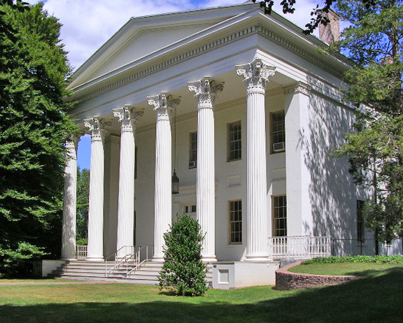
Alsop House |
 |
01970-10-06 October 6, 1970 |
301 High St.
41°33′30″N 72°39′22″W / 41.55833°N 72.65611°W / 41.55833; -72.65611 (Alsop House) |
Middletown |
Stately mansion built in "Greek-Tuscan Italianate" style in 1838-39, now incorporated of Wesleyan University. Designated a National Historic Landmark in 2009. |
| 2 |
Arrawanna Bridge |
|
02004-09-29 September 29, 2004 |
Berlin St. at the Coginchaug River
41°33′46″N 72°40′0″W / 41.56278°N 72.666667°W / 41.56278; -72.666667 (Arrawanna Bridge) |
Middletown |
An early reinforced concrete bridge, of elegant open spandrel design, blocked from use and deteriorating as of 2004 nomination. |
| 3 |
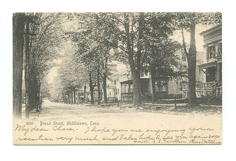
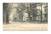
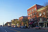
Broad Street Historic District |
 |
01988-08-25 August 25, 1988 |
Roughly bounded by High, Washington, Broad and Church Sts.
41°33′29″N 72°39′10″W / 41.55806°N 72.65278°W / 41.55806; -72.65278 (Broad Street Historic District) |
Middletown |
|
| 4 |
Church of the Holy Trinity and Rectory |
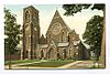 |
01979-08-14 August 14, 1979 |
381 Main St. and 144 Broad St.
41°33′40″N 72°39′6″W / 41.56111°N 72.65167°W / 41.56111; -72.65167 (Church of the Holy Trinity and Rectory) |
Middletown |
|
| 5 |
Coite-Hubbard House |
|
01978-12-20 December 20, 1978 |
269 High St.
41°33′26″N 72°39′20″W / 41.55722°N 72.65556°W / 41.55722; -72.65556 (Coite-Hubbard House) |
Middletown |
|
| 6 |
Connecticut General Hospital for the Insane |
 |
01985-08-29 August 29, 1985 |
Silver St. E. of Eastern Dr.
41°33′10″N 72°37′47″W / 41.55278°N 72.62972°W / 41.55278; -72.62972 (Connecticut General Hospital for the Insane) |
Middletown |
|
| 7 |
Highland Historic District |
|
01982-06-28 June 28, 1982 |
Atkins St. and Country Club Rd.
41°34′5″N 72°44′16″W / 41.56806°N 72.73778°W / 41.56806; -72.73778 (Highland Historic District) |
Middletown |
|
| 8 |
Nehemiah Hubbard House |
|
01982-05-11 May 11, 1982 |
Laurel Grove Rd. and Wadsworth St.
41°32′17″N 72°40′52″W / 41.53806°N 72.68111°W / 41.53806; -72.68111 (Hubbard, Nehemiah, House) |
Middletown |
|
| 9 |
Jacob Pledger House |
|
01982-03-15 March 15, 1982 |
717 Newfield St.
41°35′1″N 72°40′50″W / 41.58361°N 72.68056°W / 41.58361; -72.68056 (Pledger, Jacob, House) |
Middletown |
|
| 10 |
Plumb House |
|
01978-12-01 December 1, 1978 |
West of Middletown at 872 Westfield St.
41°33′49″N 72°42′6″W / 41.56361°N 72.70167°W / 41.56361; -72.70167 (Plumb House) |
Middletown |
|
| 11 |
Main Street Historic District (Middletown) |
 |
01983-06-30 June 30, 1983 |
Roughly Main St. between College and Hartford Ave.
41°33′45″N 72°38′56″W / 41.5625°N 72.64889°W / 41.5625; -72.64889 (Main Street Historic District) |
Middletown |
|
| 12 |
Metro South Historic District |
|
01980-01-24 January 24, 1980 |
Main and College Sts.
41°33′27″N 72°38′49″W / 41.5575°N 72.64694°W / 41.5575; -72.64694 (Metro South Historic District) |
Middletown |
|
| 13 |
Middletown Alms House |
|
01982-04-29 April 29, 1982 |
53 Warwick St.
41°32′56″N 72°39′9″W / 41.54889°N 72.6525°W / 41.54889; -72.6525 (Middletown Alms House) |
Middletown |
|
| 14 |
Middletown South Green Historic District |
|
01975-08-12 August 12, 1975 |
Union Park area, on S. Main, Crescent, Pleasant, and Church Sts.
41°33′21″N 72°38′56″W / 41.55583°N 72.64889°W / 41.55583; -72.64889 (Middletown South Green Historic District) |
Middletown |
|
| 15 |
Old Middletown High School |
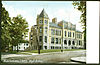 |
01985-08-23 August 23, 1985 |
Pearl and Court Sts.
41°33′30″N 72°39′13″W / 41.55833°N 72.65361°W / 41.55833; -72.65361 (Old Middletown High School) |
Middletown |
|
| 16 |
Russell Company Upper Mill |
|
01986-02-06 February 6, 1986 |
475 E. Main St.
41°32′37″N 72°38′20″W / 41.54361°N 72.63889°W / 41.54361; -72.63889 (Russell Company Upper Mill) |
Middletown |
|
| 17 |
Edward Augustus Russell House |
|
01982-04-29 April 29, 1982 |
318 High St.
41°33′32″N 72°39′20″W / 41.55889°N 72.65556°W / 41.55889; -72.65556 (Russell, Edward Augustus, House) |
Middletown |
|
| 18 |
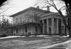
Samuel Wadsworth Russell House |
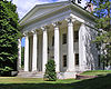 |
01970-10-06 October 6, 1970 |
350 High St.
41°33′37″N 72°39′20″W / 41.56028°N 72.65556°W / 41.56028; -72.65556 (Russell, Samuel Wadsworth, House) |
Middletown |
Greek revival mansion, designed by Ithiel Town; now part of Wesleyan University. |
| 19 |
Saint Luke's Home for Destitute and Aged Women |
|
01982-04-29 April 29, 1982 |
135 Pearl St.
41°33′42″N 72°39′25″W / 41.56167°N 72.65694°W / 41.56167; -72.65694 (Saint Luke's Home for Destitute and Aged Women) |
Middletown |
|
| 20 |
Sanseer Mill |
|
01986-07-31 July 31, 1986 |
215 E. Main St.
41°32′59″N 72°38′31″W / 41.54972°N 72.64194°W / 41.54972; -72.64194 (Sanseer Mill) |
Middletown |
|
| 21 |
Starr Mill |
 |
01993-12-14 December 14, 1993 |
Junction of Middlefield St. and Beverly Heights
41°32′55″N 72°41′28″W / 41.54861°N 72.69111°W / 41.54861; -72.69111 (Starr Mill) |
Middletown |
|
| 22 |
Starr Mill Road Bridge |
|
01993-12-10 December 10, 1993 |
Starr Mill Rd. across the Cochinaug River
41°32′56″N 72°40′38″W / 41.54889°N 72.67722°W / 41.54889; -72.67722 (Starr Mill Road Bridge) |
Middletown |
|
| 23 |
Town Farms Inn |
|
01979-05-04 May 4, 1979 |
Spring St. at River Rd.
41°33′28″N 72°37′20″W / 41.55778°N 72.62222°W / 41.55778; -72.62222 (Town Farms Inn) |
Middletown |
|
| 24 |
U.S. Post Office |
|
01982-04-12 April 12, 1982 |
291 Main St.
41°33′36″N 72°39′1″W / 41.56°N 72.65028°W / 41.56; -72.65028 (U.S. Post Office) |
Middletown |
|
| 25 |
Washington Street Historic District |
|
01985-05-09 May 9, 1985 |
Roughly bounded by Washington and Main Sts., Washington Terrace, and Vine St.
41°33′41″N 72°39′31″W / 41.56139°N 72.65861°W / 41.56139; -72.65861 (Washington Street Historic District) |
Middletown |
|
| 26 |
Wadsworth Estate Historic District |
|
01996-07-25 July 25, 1996 |
15, 30, 33, 59, 73, and 89 Laurel Grove Rd., Wadsworth Falls State Park, and 421 Wadsworth St.
41°32′2″N 72°40′44″W / 41.53389°N 72.67889°W / 41.53389; -72.67889 (Wadsworth Estate Historic District) |
Middletown |
|
| 27 |
Seth Wetmore House |
|
01970-09-10 September 10, 1970 |
CT 66 and Camp Rd.
41°33′9″N 72°41′19″W / 41.5525°N 72.68861°W / 41.5525; -72.68861 (Wetmore, Seth, House) |
Middletown |
|
| 28 |
Wilcox, Crittenden Mill |
|
01986-12-03 December 3, 1986 |
234-315 S. Main St., Pameacha, and Highlands Aves.
41°32′54″N 72°39′19″W / 41.54833°N 72.65528°W / 41.54833; -72.65528 (Wilcox, Crittenden Mill) |
Middletown |
|
| 29 |
Captain Benjamin Williams House |
|
01978-12-01 December 1, 1978 |
27 Washington St.,
41°33′46.81″N 72°38′54.34″W / 41.5630028°N 72.6484278°W / 41.5630028; -72.6484278 (Captain Benjamin Williams House) |
Middletown |
|
| 30 |
Woodrow Wilson High School |
|
01986-08-06 August 6, 1986 |
Hunting Hill Ave. and Russell St.
41°32′25″N 72°38′57″W / 41.54028°N 72.64917°W / 41.54028; -72.64917 (Woodrow Wilson High School) |
Middletown |
|
| 31 |
Xi Chapter, Psi Upsilon Fraternity |
|
02009-11-04 November 4, 2009 |
242 High St.
41°33′24.08″N 72°39′17.67″W / 41.5566889°N 72.6549083°W / 41.5566889; -72.6549083 (Xi Chapter, Psi Upsilon Fraternity) |
Middletown |
|