- National Register of Historic Places listings in Stamford, Connecticut
-
This is a list of the properties and historic districts in Stamford, Connecticut that are listed on the National Register of Historic Places. The locations of National Register properties and districts for which the latitude and longitude coordinates are included below, may be seen in a Google map.[1]
This list includes properties that are entirely or partially in Stamford.
Eleven church complexes, with 26 buildings, were covered in a Multiple Property Submission study of churches in Stamford conducted in 1987. One of these, St. Andrew's Protestant Episcopal Church, was already listed on the National Register. Some of the others were subsequently listed as result of the study.[2]:9
Current listings
[3] Landmark name[4] Image Date listed Location Description 1 Agudath Sholem Synagogue May 11, 1995 29 Grove St., in downtown Stamford[5]:3
41°3′18″N 73°32′1″W / 41.055°N 73.53361°WA former synagogue, now a church. 2 Church of the Holy Name December 24, 1987 305 Washington Blvd., in the South End[6]:9
41°2′41″N 73°32′34″W / 41.04472°N 73.54278°W3 Cove Island Houses May 22, 1979 Cove Rd. and Weed Ave., in Cove Island Park (southeastern Stamford)[7]:3
41°2′56″N 73°29′59″W / 41.04889°N 73.49972°WAlthough plural in name, this is a single house in Stamford, Connecticut that was expanded from a first section that dates from 1791. Now predominantly a Georgian style house with an older Federal style wing, it is the only remainder of the large Stamford Mills complex at the Cove.[8] 4 Deacon John Davenport House April 29, 1982 129 Davenport Ridge Rd., in North Stamford[9]:2
41°7′31″N 73°31′38″W / 41.12528°N 73.52722°WA saltbox house built in 1775 with Federal style features added later, significant for its architecture and for its association with the Davenport family.[10] 5 Downtown Stamford Historic District 
October 6, 1983 (original)
February 21, 1985 (increase I)
January 31, 2003 (increase II)Atlantic, Main, Bank, and Bedford Sts.; also bounded by Atlantic, Main, Bank, Bedford, Summer between Broad and Main Sts. and Summer Pl.; also roughly Bedford St. between Broad and Forest Sts.
41°3′57″N 73°32′25.8″W / 41.06583°N 73.5405°WA historic district which first included the largest remaining area of pre-1930s commercial and institutional buildings in downtown Stamford.[11] Its boundaries were expanded in 1985 to capture the only surviving area in downtown of lower-rent commercial structures such as warehouses, laundries, and stables.[12] and in 2002 to add the 1939-built Avon Theatre and buildings of Late Gothic Revival and Art Deco architectural styles.[13] 6 Fort Stamford Site September 10, 1975 900 Westover Rd.[14] 7 Graham House September 13, 2011 Address Restricted 8 Benjamin Hait House November 30, 1978 92 Hoyclo Rd., in North Stamford[15]:4
41°8′54″N 73°33′7″W / 41.14833°N 73.55194°WBuilt between 1728 and 1735; the oldest house in the area; a rare example of a New England farmhouse amidst a now-suburban area.[16] 9 Hoyt-Barnum House June 11, 1969 713 Bedford St., in downtown Stamford[17]
41°3′37″N 73°32′14″W / 41.06028°N 73.53722°WBuilt around 1699, a timber frame construction or post and beam farmhouse made of field stone, laid up with clay, animal hair, and straw. The house is braced timber frame construction or post and beam.[18][19] 10 John Knap House 
March 5, 1979 984 Stillwater Rd.
41°4′35″N 73°33′26″W / 41.07639°N 73.55722°WBuilt c. 1705 by a Capt. John Knap, and owned by his son, Lt. John Knap, and then grandson Samuel Knap in 1765. Believed to be the second oldest house in Stamford.[20]:7 11 Linden Apartments August 11, 1983 10-12 Linden Pl.
41°3′36″N 73°32′42″W / 41.06°N 73.545°WSecond Empire style building built in 1886; the oldest six-unit tenement apartment building in Stamford[21] 12 Long Ridge Village Historic District June 2, 1987 Old Long Ridge Rd. bounded by the New York State Line, Rock Rimmon Rd., and Long Ridge Rd./CT 104
41°9′20″N 73°35′37″W / 41.15556°N 73.59361°W
Boundary increase (listed October 20, 2011): 1-130 Mill Rd., 189-247 Old Long Ridge Rd., 1257-1306 Rock Rimmon Rd.13 Main Street Bridge May 21, 1987 Carries Main St. over the Rippowam River in downtown Stamford[22]:7
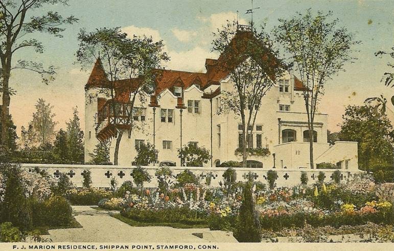
41°3′8″N 73°32′44.3″W / 41.05222°N 73.545639°W"Connecticut's only wrought-iron lenticular truss remaining on a major artery in an urban center" and one of only 17 pony truss bridges in the state, built by the Berlin Iron Bridge Company[23] 14 Marion Castle, Terre Bonne 
July 1, 1982 1 Rogers Rd., in the Shippan Point neighborhood[24]:2
41°1′23″N 73°31′45″W / 41.02306°N 73.52917°W15 Merritt Parkway 
April 17, 1991 Route 15 right-of-way between the New York state line and the Sikorsky Memorial Bridge; also located in Greenwich, Stamford, New Canaan, Norwalk, Westport, Fairfield, Trumbull, and Stratford
41°6′29.9″N 73°33′20.1″W / 41.108306°N 73.555583°WListing includes bridges crossing and bridges carrying the historic parkway. 16 Octagon House (Stamford) August 17, 1979 120 Strawberry Hill Ave.
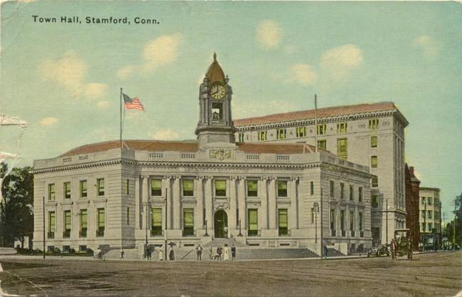
41°3′50″N 73°32′7″W / 41.06389°N 73.53528°WAn octagon house, apparently demolished but still NRHP-listed 17 Old Town Hall 
June 2, 1972 Junction of Atlantic, Bank, and Main Sts., in downtown Stamford[25]:3
41°3′11″N 73°32′26″W / 41.05306°N 73.54056°W18 Gustavus and Sarah T. Pike House May 24, 1990 164 Fairfield Ave.
41°2′46.1″N 73°33′2.9″W / 41.046139°N 73.550806°WQueen Anne style house built in 1880 that is an excellent example of pattern book application. It includes machine-made spindles and other detailing that had only recently became cost-effective with then-modern manufacturing.[26] 19 Revonah Manor Historic District July 31, 1986 Roughly bounded by Urban St., East Ave., Fifth, and Bedford Sts.
41°4′4″N 73°32′29″W / 41.06778°N 73.54139°W20 Rockrimmon Rockshelter 
August 5, 1994 Address Restricted An archeological site entered on a boulder about 60 feet high that was used as a shelter by early Native Americans. 21 St. Andrew's Protestant Episcopal Church December 6, 1983 1231 Washington Blvd. in downtown Stamford[6]
41°3′26″N 73°32′32″W / 41.05722°N 73.54222°W22 St. Benedict's Church December 24, 1987 1A St. Benedict's Circle
41°2′55.4″N 73°31′14.5″W / 41.048722°N 73.520694°W23 St. John's Protestant Episcopal Church December 24, 1987 628 Main St. in downtown Stamford[6]
41°3′17″N 73°32′2″W / 41.05472°N 73.53389°WA historic church that was built in 1869. 24 St. Luke's Chapel December 24, 1987 714 Pacific St., in the South End Historic District[27]
41°2′34″N 73°32′16″W / 41.04278°N 73.53778°W25 St. Mary's Church December 24, 1987 540 Elm St.
41°2′58.6″N 73°31′29.1″W / 41.049611°N 73.52475°WA Roman Catholic church. 26 South End Historic District 
March 19, 1986 Roughly bounded by Metro-North railroad tracks, Stamford Canal, Woodland Cemetery, and Washington Blvd.
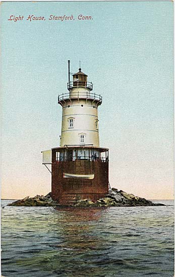
41°2′36.3″N 73°32′16.3″W / 41.043417°N 73.537861°WHistoric district that includes 449 buildings, most dating from the 1870s to the 1930s, and also "an early naturalistic cemetery, and an iron bridge."[28] 27 Stamford Harbor Lighthouse 
April 3, 1991 South of breakwater, Stamford Harbor
41°0′49″N 73°32′35″W / 41.01361°N 73.54306°W28 C. J. Starr Barn and Carriage House September 14, 1979 200 Strawberry Hill Ave.
41°4′3″N 73°32′6″W / 41.0675°N 73.535°W29 Suburban Club August 10, 1989 6 Suburban Ave./580 Main St., in downtown Stamford[29]:2
41°3′16″N 73°32′8″W / 41.05444°N 73.53556°W30 Turn-of-River Bridge July 31, 1987 Old North Stamford Road at Rippowam River in northern Stamford[30]:2
41°6′54″N 73°32′42″W / 41.115°N 73.545°WA lenticular pony truss bridge built by the Berlin Iron Bridge Company in 1892, using a design patented by William O. Douglas in 1878 for a lens-type truss bridge. It brings the Old Stamford Road across Rippowam River.[31] 31 Unitarian-Universalist Church December 24, 1987 20 Forest St. in downtown Stamford[6]
41°3′27″N 73°32′14″W / 41.0575°N 73.53722°W32 US Post Office-Stamford Main 
December 12, 1985 421 Atlantic St.
41°2′59″N 73°32′22″W / 41.04972°N 73.53944°W33 Zion Lutheran Church December 24, 1987 132 Glenbrook Rd.
41°3′35″N 73°31′39″W / 41.05972°N 73.5275°WA "fine example of ecclesiastical Neo-Gothic architecture", built of red brick.[32] See also
- National Register of Historic Places listings in Fairfield County, Connecticut
- National Register of Historic Places listings in Greenwich, Connecticut
- National Register of Historic Places listings in Bridgeport, Connecticut
- List of National Historic Landmarks in Connecticut
References
- ^ The latitude and longitude information provided in this table was derived originally from the National Register Information System, which has been found to be fairly accurate for about 99% of listings. For about 1% of NRIS original coordinates, experience has shown that one or both coordinates are typos or otherwise extremely far off; some corrections may have been made. A more subtle problem causes many locations to be off by up to 150 yards, depending on location in the country: most NRIS coordinates were derived from tracing out latitude and longitudes off of USGS topographical quadrant maps created under North American Datum of 1927, which differs from the current, highly accurate GPS system used by Google maps. Chicago is about right, but NRIS longitudes in Washington are higher by about 4.5 seconds, and are lower by about 2.0 seconds in Maine. Latitudes differ by about 1.0 second in Florida. Some locations in this table may have been corrected to current GPS standards.
- ^ Jan Cunningham and John Herzan (April 15, 1987). "Multiple Property Study: Downtown Stamford Ecclesiastical Complexes (Thematic Resources)". National Park Service. http://pdfhost.focus.nps.gov/docs/NRHP/Text/64000089.pdf.
- ^ Numbers represent an ordering by significant words. Various colorings, defined here, differentiate National Historic Landmark sites and National Register of Historic Places Districts from other NRHP buildings, structures, sites or objects.
- ^ "National Register Information System". National Register of Historic Places. National Park Service. 2009-03-13. http://nrhp.focus.nps.gov/natreg/docs/All_Data.html.
- ^ [1]
- ^ a b c d [2]
- ^ [3]
- ^ David F. Ransom (October 16, 1977). "National Register of Historic Places Inventory-Nomination: Cove Island Houses". National Park Service. http://pdfhost.focus.nps.gov/docs/NRHP/Text/79002652.pdf. and Accompanying 9 photos, exterior and interior and of mills, from 1977
- ^ [4]
- ^ Hal Keiner (June 18, 1979). "National Register of Historic Places Inventory-Nomination: Deacon John Davenport House". National Park Service. http://pdfhost.focus.nps.gov/docs/NRHP/Text/82004611.pdf. and Accompanying 7 photos, exterior and interior, from 1979
- ^ Nils Kerschus and John Herzan (January, 1983). "National Register of Historic Places Inventory-Nomination: Downtown Stamford Historic District". National Park Service. http://pdfhost.focus.nps.gov/docs/NRHP/Text/83003502.pdf. and Accompanying six photos, from 1982 and 1983
- ^ Nils Kerschus and John Herzan (December, 1983). "National Register of Historic Places Inventory-Nomination: Downtown Stamford Historic District (Boundary Increase)". National Park Service. http://pdfhost.focus.nps.gov/docs/NRHP/Text/85000311.pdf. and Accompanying six photos, from 1984
- ^ Ellen Meager and Nils Kerschus (July 1, 2002). "National Register of Historic Places Inventory-Nomination: Downtown Stamford Historic District (Boundary Increase)". National Park Service. http://pdfhost.focus.nps.gov/docs/NRHP/Text/02001744.pdf. and Accompanying 29 photos, from 2002 (see photo captions and maps page 21-23 of text document)
- ^ [5]
- ^ [6]
- ^ Charles W. Brilvitch (September 27, 1978). "National Register of Historic Places Inventory-Nomination: Benjamin Hait House". National Park Service. http://pdfhost.focus.nps.gov/docs/NRHP/Text/78002844.pdf. and Accompanying two photos, exterior, from 1977
- ^ [7]
- ^ Stamford Historical Society website retrieved on 2009-05-12
- ^ Herbert C. Darbee (April 23, 1969). "National Register of Historic Places Inventory-Nomination: Hoyt-Barnum House / Hoyt Farm House / Betsy Barnum House". National Park Service. http://pdfhost.focus.nps.gov/docs/NRHP/Text/69000199.pdf. and Accompanying 5 photos, exterior and interior, from 1969
- ^ David F. Ransom (October 17, 1977). "National Register of Historic Places Inventory-Nomination: John Knap House". National Park Service. http://pdfhost.focus.nps.gov/docs/NRHP/Text/79002625.pdf. and Accompanying eight photos, exterior and interior, from 1977
- ^ Nils Kerschus and John Herzan (June, 1983). "National Register of Historic Places Inventory-Nomination: Linden Apartments". National Park Service. http://pdfhost.focus.nps.gov/docs/NRHP/Text/83001252.pdf. and Accompanying six photos, exterior and interior, from 1982
- ^ [8]
- ^ Stephen Bedford and John Herzan (September 2, 1998). "National Register of Historic Places Inventory-Nomination: Main Street Bridge". National Park Service. http://pdfhost.focus.nps.gov/docs/NRHP/Text/87000801.pdf. and Accompanying eight photos from 1986
- ^ [9]
- ^ [10]
- ^ Jan Cunningham (December 14, 1989). "National Register of Historic Places Inventory-Nomination: Gustavus and Sarah T. Pike House". National Park Service. http://pdfhost.focus.nps.gov/docs/NRHP/Text/90000759.pdf. and Accompanying nine photos, exterior and interior, from 1989 (see photo captions and map pages 8-9 of text document)
- ^ [11]
- ^ Nils Kerschus and John Herzan (August, 1985). "National Register of Historic Places Inventory-Nomination: South End Historic District". National Park Service. http://pdfhost.focus.nps.gov/docs/NRHP/Text/86000472.pdf. and Accompanying 24 photos, from 1984 and 1985
- ^ [12]
- ^ [13]
- ^ Steven Bedford (August 25, 1986). "National Register of Historic Places Inventory-Nomination: Turn-of-River Bridge / Old North Stamford Road Bridge". National Park Service. http://pdfhost.focus.nps.gov/docs/NRHP/Text/87000798.pdf. and Accompanying nine photos, from 1986
- ^ Jan Cunningham (April 20, 1987). "Historic Resources Inventory Buildings and Structures: Zion Lutheran Church". National Park Service. http://pdfhost.focus.nps.gov/docs/NRHP/Text/87002127.pdf. and Accompanying photo, exterior, from 1987
U.S. National Register of Historic Places in Connecticut Lists by county 
Lists by city Bridgeport • Greenwich • Hartford • Middletown • New Haven • Southington • Stamford • West Hartford • WindsorOther lists Categories:- Fairfield County, Connecticut
- National Register of Historic Places in Connecticut
- Stamford, Connecticut


Wikimedia Foundation. 2010.