- Slater-Marietta, South Carolina
-
Slater-Marietta, South Carolina — CDP — Location of Slater-Marietta, South Carolina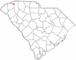
Coordinates: 35°1′45″N 82°29′51″W / 35.02917°N 82.4975°WCoordinates: 35°1′45″N 82°29′51″W / 35.02917°N 82.4975°W Country United States State South Carolina County Greenville Area – Total 4.3 sq mi (11.1 km2) – Land 4.3 sq mi (11.1 km2) – Water 0.0 sq mi (0.0 km2) Population (2000) – Total 2,228 – Density 518.5/sq mi (200.2/km2) Time zone Eastern (EST) (UTC-5) – Summer (DST) EDT (UTC-4) FIPS code 45-66917[1] Slater-Marietta is a census-designated place (CDP) in Greenville County, South Carolina, United States, along the North Saluda River. The population was 2,228 at the 2000 census. It is part of the Greenville–Mauldin–Easley Metropolitan Statistical Area.
Geography
Slater-Marietta is located at 35°1′45″N 82°29′51″W / 35.02917°N 82.4975°W (35.029244, -82.497410)[2].
According to the United States Census Bureau, the CDP has a total area of 4.3 square miles (11.1 km²), all of it land.
Demographics
As of the census[1] of 2000, there were 2,228 people, 875 households, and 594 families residing in the CDP. The population density was 518.5 people per square mile (200.1/km²). There were 989 housing units at an average density of 230.2/sq mi (88.8/km²). The racial makeup of the CDP was 95.96% White, 0.81% African American, 0.04% Native American, 0.04% Asian, 0.04% Pacific Islander, 2.29% from other races, and 0.81% from two or more races. Hispanic or Latino of any race were 7.99% of the population.
There were 875 households out of which 30.1% had children under the age of 18 living with them, 50.7% were married couples living together, 11.2% had a female householder with no husband present, and 32.1% were non-families. 26.4% of all households were made up of individuals and 11.5% had someone living alone who was 65 years of age or older. The average household size was 2.48 and the average family size was 2.94.
In the CDP the population was spread out with 23.6% under the age of 18, 10.0% from 18 to 24, 30.6% from 25 to 44, 21.0% from 45 to 64, and 14.9% who were 65 years of age or older. The median age was 36 years. For every 100 females there were 98.8 males. For every 100 females age 18 and over, there were 92.2 males.
The median income for a household in the CDP was $30,898, and the median income for a family was $36,190. Males had a median income of $26,950 versus $23,603 for females. The per capita income for the CDP was $17,169. About 12.7% of families and 17.8% of the population were below the poverty line, including 14.0% of those under age 18 and 16.5% of those age 65 or over.
References
- ^ a b "American FactFinder". United States Census Bureau. http://factfinder.census.gov. Retrieved 2008-01-31.
- ^ "US Gazetteer files: 2010, 2000, and 1990". United States Census Bureau. 2011-02-12. http://www.census.gov/geo/www/gazetteer/gazette.html. Retrieved 2011-04-23.
Municipalities and communities of Greenville County, South Carolina Cities Fountain Inn‡ | Greenville | Greer‡ | Mauldin | Simpsonville | Travelers Rest
CDPs Berea | City View | Dunean | Five Forks | Gantt | Golden Grove | Judson | Parker | Piedmont‡ | Sans Souci | Slater-Marietta | Tigerville | Taylors | Wade Hampton | Ware Place | Welcome
Footnotes ‡This populated place also has portions in an adjacent county or counties
Categories:- Greenville County, South Carolina
- Census-designated places in South Carolina
- Greenville, South Carolina metropolitan area


Wikimedia Foundation. 2010.