- Late-May 1998 tornado outbreak and derecho
-
The Late-May 1998 Tornado Outbreak and Derecho was a historic tornado outbreak and derecho that began on the afternoon of May 30 extending throughout May 31, 1998, across a large portion of the northern half of the United States and southern Ontario from southeastern Montana east and southeastward to the Atlantic Ocean. The initial tornado outbreak, including the devastating Spencer tornado, hit southeast South Dakota on the evening of the May 30. The Spencer tornado was the most destructive and second deadliest tornado in South Dakota history. 13 people were killed; 7 by tornadoes and 6 by the derecho, and damage was estimated at least $500 million in damage. Over two million people lost electrical power, some for up to 10 days.
The derecho was the most violent line of thunderstorm observed on earth during the 1998 calendar year according to the National Weather Service review shortly after the year was over.[citation needed] It was also the climax of an unusually heavy derecho season in the North-Central United States and adjacent parts of Canada and the Northeast U.S., and this storm combined the characteristics of the two major forms of derecho, the serial and progressive derecho. At various points of its evolution, it displayed textbook and/or record manifestations of supercell and derecho-related phenomena such as the right-mover supercell, evolution of supercells into a linear mesoscale feature which rapidly became a derecho, cumulonimbus with overshooting top and dome, bow echo, bookend vortices, regular and rotor downbursts, gust front, gustnado, rear inflow notch, classic derecho radar signature, effects of infrasound and atmospheric electricity, haboobs, and wind effects on bodies of water including seiches and exposure of bottoms of water features by the wind. The disturbance which was originally the derecho finally disappeared off the coast of Norway more than a week later.
Contents
Meteorological synopsis
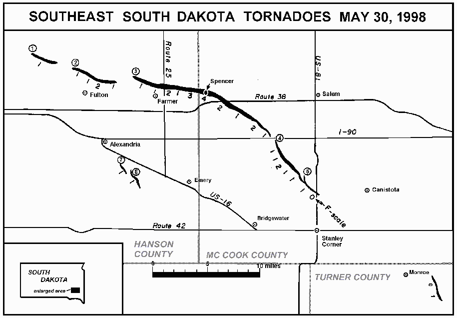
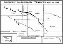 NWS damage survey map tracking the tornado families in southeast South Dakota
The first severe weather of the outbreak was reported at 12:30 pm in southeast Montana. Several hours later a supercell thunderstorm produced 2¾ inch (7 cm) hail across southeast Montana, kicking off the outbreak in earnest. Numerous reports of very large hail were received throughout the outbreak with the largest official report of 3 inches (75 mm) 10 miles (16 km) north of St. Lawrence in east-central South Dakota. The hail itself produced thousands of dollars in damage. Many reports of severe straight-line winds and damage were also reported. Numerous storm chaser reports suggest that significant severe weather events also occurred in the sparsely populated area traversed by the storm.
The family of tornadoes that crossed the Spencer area was observed by a Doppler On Wheels (DOW) radar (Wurman et al. 1997, Wurman 2001). The DOW observed the tornado or tornadoes from before 8:04 through 8:45 pm local time (01:04-01:45 UTC) (Alexander and Wurman 2005) and the tornado's passage through Spencer itself from 8:37-8:38 pm (01:37-01:38 UTC). DOW measurements of tornadic winds over the largely destroyed southern portion of Spencer have permitted the first (and only as of 12/2006) direct comparison of measured winds with F (or EF) Scale damage ratings as reported in the above referenced articles. Peak observed Doppler winds of near 115 m/s (258 mph) corresponded well with the documented F4 damage.
The DOW observations showed that the list of tornadoes derived from damage surveys alone, and the F-scale rating of that damage, may be incomplete and underestimate actual tornado intensity(Wurman and Alexander 2005). Single tornadoes may be mis-characterized as multiple tornadoes due to breaks in the observed damage.
DOW measurements suggest that the tornado may have a multiple vortex structure as it crossed Spencer.
Confirmed tornadoes
Confirmed
TotalConfirmed
F0Confirmed
F1Confirmed
F2Confirmed
F3Confirmed
F4Confirmed
F518 7 7 3 0 1 0 May 30 South Dakota event
List of confirmed tornadoes F# Location County Time (UTC) Path length Damage South Dakota F0 W of Lake Preston Kingsbury 0002 unknown First tornado touchdown. Short-lived with no damage. F1 NW of Fulton Hanson 0008 2 miles
(3.2 km)This was a fairly large and dusty tornado that affected mostly open ground in rural areas. It was the first tornado of the tornado family generated by the supercell that produced the Spencer tornado. F2 NE of Fulton Hanson 0016 6 miles
(9.6 km)Large tornado that produced minor damage, mostly remaining in open fields and trees. This was the second tornado of the Spencer tornado family. F4 Spencer area Hanson, McCook 0026 14 miles
(23 km)6 deaths - See section on this tornado F1 SE of Alexandria Hanson 0055 2 miles
(3.2 km)Tornado not related to the Spencer tornado family; it formed on a rear flank downdraft (RFD) of the Spencer supercell and tracked roughly to the south of that storm. Multiple major tornadoes from these two supercells were often ongoing and visible simultaneously. This tornado resulted in moderate damage to crops and several buildings. F2 S of Salem McCook 0056 6 miles
(9.6 km)Large tornado that resulted in significant damage to numerous farm buildings and houses, as well as extensive power line and crop damage. This too was a very large and strong tornado incurring about $1.0 million in damages to farm property, power lines, and crops. Tornado was 700 yards (650 m) wide. F1 W of Emery Hanson 0101 2 miles
(3.2 km)Related to the Alexandria tornado. Minor damage reported. F1 W of Canistota Hanson 0107 1 miles
(1.6 km)Final tornado from the Spencer tornado family. Significant damage reported to one farm. F0 E of Emery Hanson 0110 unknown F1 E of Monroe Turner 0125 1 mile
(1.6 km)Moderate property damage reported. Sources: NCDC Embedded in derecho
List of confirmed tornadoes F# Location County Time (UTC) Path length Damage Wisconsin F2 E of Menomonie Dunn 0428 1 mile
(1.6 km)Three houses, including a mobile home, were destroyed. Heavy damage also reported on several farms. 8 people were injured. F0 SW of Mosinee Marathon 0621 200 yd
(180 m)Brief tornado embedded in the damage from the derecho. F1 N of Stockbridge Calumet 0720 1 mile
(1.6 km)Considerable damage reported in the area. Two barns were destroyed, along with a garage and silo. Damage also reported to one house. Michigan F0 SE of Lake City Missaukee 0930 500 yd
(450 m)Numerous trees were snapped. F0 Torch Lake Antrim 0935 unknown Brief tornado touchdown with minimal damage. F1 N of Kalkaska Kalkaska 0950 7 miles
(11 km)One mobile home was destroyed and two others were damaged. Extensive tree damage reported. F0 N of Grayling Crawford 0955 unknown Brief tornado touchdown. One house sustained heavy damage. F0 W of Flushing Genesee 1025 unknown Tornado confirmed amidst heavy derecho damage. Minor tornado-related tree and building damage. Sources: NCDC May 31 Northeast event
Spencer, South Dakota tornado
 The Spencer, South Dakota tornado
The Spencer, South Dakota tornado was the most destructive and second deadliest tornado in the history of the state. It was also the fifth deadliest tornado of the year.[1] It began as a large, dust-cloaked tornado Northwest of Farmer, SD in Hanson County, concurrent with the demise of the "Fulton" tornado. Continuing toward the East-Southeast, it struck several farmsteads before crossing the Hanson/McCook County line a half mile West-Northwest of Spencer. At this time, the tornado was being observed by OU's Doppler on Wheels crew, whose mobile Doppler radar data showed up to 220 mph winds in the tornado only a few decameters above the ground.[2]
This tornado carved a 3/8 mile (600 m) wide path directly across the town of Spencer between 8:38 and 8:44 CDT, destroying or damaging all but a few houses on the northeast side of town. The tornado killed six people, injured more than one-third of the town residents, and destroyed most of the town's 190 buildings. Damage has been estimated at $18 million.[3] The population of the town diminished soon after to less than half of what it was previous to the tornado, from 315 to 145 in April 1999.
Southern Great Lakes derecho
This derecho got its start from a developing low pressure system that moved into the northern Great Plains and Great Lakes. The derecho formed from the same storm system that spawned the Spencer, SD Tornado, which killed six people. The supercell thunderstorm which produced that tornado transitioned into the derecho which killed another six people.
Late in the evening on May 30, the tornado-producing supercells merged and became one squall line. It developed further and became a bow echo system.
It would become the most destructive natural disaster to hit the Upper Midwest in recent memory.
 Timeline of the derecho
Minnesota
The most damage in Minnesota occurred at the northern edge in Sibley and McLeod Counties. Winds ranged from 80-100 mph (128–160 km/h) in those two counties.
As the derecho raced through Minnesota, tens of thousands of trees were blown down. There were 500,000 customers without power. Over 100 homes were destroyed or damaged beyond repair. Twenty-two people were injured. The derecho caused $50 million in damage in southern Minnesota and northern Wisconsin.
Wisconsin
The derecho raced across Wisconsin in only three hours killing one person in Washington County when a tree fell through the roof and onto her bed where she was sleeping. It injured 37 people in Wisconsin. Many utility companies and emergency customers said that this was the most damaging straight-line wind thunderstorm event in 100 years. Five thousand homes and businesses were damaged and 24 were destroyed.
An area of south-central, south-east, and east-central Wisconsin reported wind gusts of over 100 mph (160 km/h) from this thunderstorm complex with an all-time official state record gust of 128 mph (206 km/h) 1½ miles (3 km) north-west of Lebanon in Dodge County. As with other derechos like the July 4, 1977 blow-down in northern Wisconsin, there were other unofficial reports of higher winds as well as estimates of such, including winds of 102 mph (165 km/h) sustained for a number of minutes and gusts up to 140 mph (225 km/h) also in Dodge County and/or adjacent sections of Fond du Lac County.
The roar of the wind from the derecho was audible up to 30 miles (50 km) away as the storm traversed this region. Road signs and other metal structures were found thrown about and even violently twisted in the area of 100 mph-plus wind from north-east Dane County through Dodge and Fond du Lac and Washington counties—evidence of both straight-line winds and rotor downbursts were widespread in this area as well as many other points along the path of the storm, and the sound of wind and perhaps hail and the effects of infrasound from some parts of the storm complex was also reported. In the latter case, some people reported strange feelings of pressure and dogs, cats, and raccoons went wild.
The derecho also caused boating accidents by generating a seiche on Lake Michigan which was reported to be around 10 feet (3 m) high as it first struck the Michigan coastline of Lake Michigan further north in Muskegon County.
Central Great Lakes
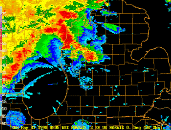 Radar loop of the derecho crossing Lower Michigan on May 31, 1998 (NWS Detroit)
The storm raced through Michigan in only two hours at an average speed of 70 mph (112 km/h). Four people were killed in Michigan, and 146 were injured. Total damage was estimated at $172 million (1998 dollars). 250 homes and 34 businesses were destroyed. In Grand Haven the Story & Clark smokestack at the Piano Factory Condominiums was destroyed when the force of the high wind caused it to crumble, and trees collapsed all over the city, some falling onto roofs. Damage in Spring Lake was worse, due to a highly localized zone of higher winds. The Mill Pointe Condominiums suffered serious damage, including the collapse of one unit. Others were subsequently removed. A factory lost its roof in the storm, and a number of businesses were damaged severely, one beyond repair. Country Estates Mobile Home park also suffered serious damage. A woman was killed in Pinconning, about 130 miles (208 km) north of Detroit, when a tree fell on her house. Extensive damage to Walker (approximately 30 miles (50 km) inland) led to the city being closed off, with no traffic allowed to enter in the day after the derecho's passage.
At Michigan's Adventure amusement park, the Mutley's Putt-Putts car ride was destroyed by the derecho. The park would later build an entrance on the site of the attraction. Numerous trees were also leveled throughout the park, making shade a rare commodity for a few years until transplanted trees could be brought in.[1]
This derecho would go on to break the record for biggest power outage ever in the state of Michigan (but later surpassed by the 2003 North America blackout). 860,000 people lost power, slightly more than the amount from the Southern Great Lakes Derecho of 1991. It blew down five 345-kilovolt transmission towers owned by Consumers Energy.
Thirteen counties in Central Lower Michigan were declared federal disaster areas.
One person drowned in Ontario when his boat turned over from the derecho's strong winds. Buildings in Toronto lost numerous windows and significant damage was observed in areas such as Trenton, Napanee, Picton and Kingston. Heavy thunderstorm activity was also reported in Ottawa and Montreal, Quebec but without damage.
It caused $300,000 worth of damage in central New York before reforming into a tornado outbreak at around 11 am on May 31.
Across the southeast part of Michigan, the National Weather Service in Detroit/Pontiac, based in White Lake Township reported a combined total of 87 individual severe weather events with 84 of them occurring in two hours' time, from 5:50 to 7:50 am Eastern Daylight Time or 0550 to 0750 UTC). In addition the office also reported a combined total of 25 warnings (21 severe thunderstorm and 4 tornado) issued with 18 of the warnings being issued in an hour's time (6:00 to 7:00 am Eastern Daylight Time or 0600 to 0700 UTC).[2] The table that follows runs down all of the warnings issued across Southeast Michigan. Note that Detroit EDT stands for Detroit, which is part of the Eastern Time Zone in North America and that Norman CDT stands for Norman, Oklahoma, located in the Central Time Zone, home of the National Weather Service's Storm Prediction Center.
Time (Detroit EDT) Time (Norman CDT) Time (UTC) County / Counties ST or TOR Warning 5:37 AM (0537) 4:37 AM (0437) 9:37 AM (0937) Midland Severe Thunderstorm Warning 5:46 AM (0546) 4:46 AM (0446) 9:46 AM (0946) Bay, Saginaw and Shiawassee Severe Thunderstorm Warning 6:06 AM (0606) 5:06 AM (0506) 10:06 AM (1006) Lenawee, Livingston and Washtenaw Severe Thunderstorm Warning 6:13 AM (0613) 5:13 AM (0513) 10:13 AM (1013) Genesee and Tuscola Severe Thunderstorm Warning 6:25 AM (0625) 5:25 AM (0525) 10:25 AM (1025) Genesee and Shiawassee Tornado Warning 6:31 AM (0631) 5:31 AM (0531) 10:31 AM (1031) Huron, Lapeer, Oakland and Sanilac Severe Thunderstorm Warning 6:53 AM (0653) 5:53 AM (0553) 10:53 AM (1053) Macomb, Monroe, St. Clair and Wayne Severe Thunderstorm Warning 6:59 AM (0659) 5:59 AM (0559) 10:59 AM (1059) Lenawee, Livingston and Washtenaw Severe Thunderstorm Warning 7:33 AM (0733) 6:33 AM (0633) 11:33 AM (1133) Macomb and Wayne Tornado Warning 8:46 AM (0846) 7:46 AM (0746) 12:46 PM (1246) Monroe Severe Thunderstorm Warning Summary
Overall, the derecho traveled 975 miles (1560 km) from southern Minnesota to central New York in 15 hours at an average speed of 65 mph (104 km/h). It became one of the most damaging derecho events in North America's history, causing $300 million in damage and 6 deaths.
Northeastern North America tornado outbreak
That afternoon, as the derecho dissipated, the outflow boundary moved into a very warm and unstable airmass which was in place (CAPE was above 2400 J/kg). Thunderstorms developed along this boundary and quickly became severe. One particularly severe thunderstorm which later went on to produce an F3 tornado in Mechanicville, NY developed at 4:02 pm. At 4:12 pm, the storm shows strong rotation with 64+ kt (33+ m/s) winds at 5,000 feet (1,500 m) in the mesocyclone. At 4:15, this storm produced 1 inch (25 mm) hail and a 52 mph (23 m/s) wind gust. At 4:17 pm, rotation increases, and at 4:20 pm the storm produced 1¾ inch (45 mm) hail. At 4:22 pm, Albany Doppler radar shows a strong and deep TVS, with 105+ kt winds. This is also the same time a tornado is reported on the ground.
The most destructive tornado of the day tore through Mechanicville and the adjacent town of Stillwater. It caused major damage to the town's old industrial section located on Route 4 and 32 along the Hudson River. One of the two historic smokestacks (visible from 2 miles (3.2 km) away) was knocked down by the tornado. In 2005, the other smokestack and the conjoined building were bulldozed. The tornado was rated F3 on the Fujita scale.
Several other tornadoes touched down across New York and Pennsylvania with one of the tornadoes causing a fatality in the Salisbury, Pennsylvania area.[3] Another tornado caused major damage to the town of Lyons[4] while another caused major damage around the Binghamton Metro Area including TV station WIVT sustained heavy damage which forced them to be off the air for several months.[5] Activity ceased late in the evening across the southeastern portion of Pennsylvania. A total of 41 tornadoes were confirmed during the post-derecho outbreak. In total, 1 was killed, dozens injured, and damages for the outbreak were at least $100 million.
Confirmed tornadoes
Confirmed
TotalConfirmed
F0Confirmed
F1Confirmed
F2Confirmed
F3Confirmed
F4Confirmed
F541 15 12 8 6 0 0 May 31 New York event
List of confirmed tornadoes F# Location County Time (CDT) Path length Damage Indiana F0 Spencerville area DeKalb 1244 0.1 miles
(0.16 km)Report from law enforcement F0 Auburn area DeKalb 1315 0.1 miles
(0.16 km)Brief touchdown with no damage Ohio F0 Continental area Putnam 1404 0.1 miles
(0.16 km)Brief touchdown with no damage F1 SE of Hickoryville Clinton 1825 0.3 miles
(0.5 km)Damage limited to trees Ontario F0 SE of Trenton Prince Edward 1445 unknown New York F3 W of Round Lake, NY to E of North Bennington, VT Saratoga, NY, Rensselaer, Bennington, VT 1522 30.5 miles
(48.8 km)This tornado had a total path length of 31 miles (50 km), crossing through 3 counties and 2 states (NY and VT). 350 homes and businesses damaged or destroyed along its entire track, 68 injuries, and about $70M in damage. There was also extensive forest damage. Width was 970 yards. In Vermont, extensive F2 damage occurred to homes. Damage was $630,000. Width was 200 yards. F1 SW of Colonie area Albany 1537 3.5 miles
(5.6 km)This was a small tornado that crossed the Albany International Airport and the New York State Thruway. It was 75 yards wide and produced $25,000 in damage. F0 Davenport area Delaware 1545 3 miles
(4.8 km)Small tornado which produced $150,000 in damage. Width was 75 yards. F1 Brocton area Chautauqua 1605 2 miles
(3.2 km)Small tornado which caused 2 injuries and $90,000 in damage. Width was 25 yards. F3 Apalachin to Downsville Tioga, Broome, Delaware 1630 62 miles
(99.2 km)In Tioga County, it was a small tornado which skipped along hilltops causing $50,000 in damage. Width was 50 yards. In Broome County, it was a large tornado which moved through the Town of Binghamton. This tornado made a direct hit on the local ABC affiliate television station causing major damage. This is a continuation of the above Tioga County tornado. This moved through 3 counties and had a discontinuous total path length of over 60 miles. 12 people were injured and it produced $1.5M in damages. Width was 200 yards. In Delaware County, this tornado caused severe damage to several homes and forested areas. Baseball sized hail was reported falling from this thunderstorm. Damage approached $1 million. Width was 200 yards. F2 Plymouth area Chenango 1650 1 miles
(1.6 km)This tornado was short lived but had a massive width of over 1500 yards. It produced $500,000 in damage. F0 North Norwich area Chenango 1700 0.5 miles
(0.8 km)Caused $135,000 in damage. Width was 75 yards. F0 Portlandville area Otsego 1725 1 miles
(1.6 km)Caused $75,000 in damage. Width was 30 yards. F3 Laurens area Otsego 1730 5 miles
(8 km)This tornado caused heavy damage to forested areas and several homes. 3 people were injured, and $800,000 worth of damage occurred. The path was 800 yards wide. F2 East Schodack area Rensselaer 1822 8 miles
(12.8 km)Pennsylvania F1 E of Buttonwood Lycoming 1620 0.5 miles
(0.8 km)A shed was destroyed and the roof of a lumberyard building was blown off F0 E of Hughestown Luzerne 1800 0.2 miles
(0.32 km)Damage to trees and utility poles F1 S of Johnsonburg Elk 1830 3 miles
(4.8 km)Damage to trees and farmland F0 NW of Ridgway Elk 1830 0.5 miles
(0.8 km)Damage limited to trees F2 SW of Blooming Grove Pike 1908 2 miles
(3.2 km)Some homes at a campsite sustained minor to moderate damage. Extensive tree damage was observed at Promise Land State Park. F1 S of Jericho Cameron, Clinton 1910 5 miles
(8 km)Damage limited to trees F3 N of Pecks Pond to Dingmans Ferry Pike 1920 20 miles
(32 km)A summer home was leveled and a mobile home was severely damaged F2 N of Blooming Grove Pike 1920 3 miles
(4.8 km)F0 W of Wimmers Lackawanna 1920 0.3 miles
(0.5 km)Damage limited to trees F0 W of Old Forge Lackawanna 1920 0.1 miles
(0.16 km)Windows of a restaurant were blown away F1 NE of Salladasburg Lycoming 1945 7 miles
(11.2 km)A haywagon, several sheds and numerous trees were damaged while a garage and breezeway were destroyed. F3 Salisbury area Somerset 1950 13 miles
(20.8 km)1 death A farmhouse was destroyed. 10 to 15 businesses, several homes, a factory and a church sustained minor to significant damage. F0 W of Jericho Wayne 1950 0.5 miles
(0.8 km)Damage to trees and power lines F3 Lyons area Berks 2000 8.3 miles
(13.3 km)40 homes were damaged to destroyed F0 Montoursville area Lycoming 2002 0.5 miles
(0.8 km)One hangar was damaged heavily and three others sustained minor damage while some planes at the Lycoming County Airport were tossed around. F0 S of Hughesville Lycoming 2015 0.2 miles
(0.32 km)A trailer was destroyed while a second was blown off its foundation F1 N of Beaumont Wyoming 2015 0.5 miles
(0.8 km)One house sustained minor damage F0 W of Greentown Pike 2050 0.3 miles
(0.5 km)Brief tornado with no damage F2 NE of Quarryville Lancaster 2330 7 miles
(11.2 km)One barn was destroyed while six homes and several barns were damaged F1 NE of Daleville Chester 2343 6 miles
(9.6 km)F1 S of Pocopson Chester 2352 3 miles
(4.8 km)5 homes were heavily damaged and 43 others less severely damaged. One mobile home was destroyed F2 Trevose Bucks 0020 5.6 miles
(9 km)35 commercial building were damaged New Hampshire F2 S of Antrim Hillsborough 1703 0.5 miles
(0.8 km)A wall from an elementary school was damaged while a boat and trailer were flipped over. Connecticut F1 SW of Washington Litchfield 2030 0.3 miles
(0.5 km)Damage limited to trees Kentucky F2 E of Pellyton Adair 2035 1 miles
(1.6 km)A brick home was heavily damaged while several mobile homes were destroyed. F1 N of Fonde Bell 2148 1.5 miles
(2.4 km)Two mobile homes were destroyed while 12 homes and 2 churches were damaged Sources: NCDC, Tornado History Project - May 31, 1998 Storm Data 1998 Ontario Tornadoes See also
References
External links
- "Origins And Synoptic Setting For The 30- 31 May 1998 Minnesota To New York Derecho" (NWS Twin Cities, MN)
- "The Southern Great Lakes Derecho of 1998" (Storm Prediction Center)
- 10-Year anniversary page of the outbreak (NWS Binghamton)
- 10th Anniversary page from the NWS Albany
- "Upper Midwest hit by hurricane-force storm" (CNN)
- Detailed SPC overview
- NWS overview
- CIMMS satellite imagery and meteorological analysis
- CSWR Doppler-on-wheels Spencer page
- DOC-NOAA-NWS Service Assessment
- Informative South Dakota Public Broadcasting website
- Andy Schmidt's Spencer website with tornado and damage photos and aftermath information
- Original CNN Spencer report
- CNN report on entire outbreak
Categories:- F4 tornadoes
- Tornadoes of 1998
- 1998 meteorology
- 1998 natural disasters
- Tornadoes in New York
- Tornadoes in South Dakota
- Tornadoes in Wisconsin
- Derechos in the United States
- Derechos in Canada
- Natural disasters in Minnesota
- Natural disasters in Ontario
- McCook County, South Dakota
- Tornadoes in Michigan
- Hanson County, South Dakota
- 1998 in the United States
- Natural disasters in New York


Wikimedia Foundation. 2010.