- Millisle
-
Coordinates: 54°36′29″N 5°31′44″W / 54.608°N 5.529°W
Millisle Irish: Oileán an Mhuilinn 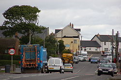
Millisle Main Street, August 2006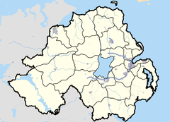
 Millisle
Millisle shown within Northern IrelandPopulation 1,800 (2001 Census) District Ards Borough County County Down Country Northern Ireland Sovereign state United Kingdom Post town NEWTOWNARDS Postcode district BT22 Dialling code 028 Police Northern Ireland Fire Northern Ireland Ambulance Northern Ireland EU Parliament Northern Ireland UK Parliament North Down Website http://www.millisle.org/ List of places: UK • Northern Ireland • Down Millisle or Mill Isle is a village on the Ards Peninsula in County Down, Northern Ireland. It is mostly within the townland of Ballymacruise,[1] about 3 miles (4.8 km) south of Donaghadee. It had a population of 1,800 in the 2001 Census. It has been described as an "unpretentious bucket-and-spade resort of fish-and-chip shops and acres of caravan sites".[2]
Contents
History
As Nazi abuse of the Jews increased, the British Jewish Refugee Committee organised Kindertransport with the help of the British government.[3] About ten thousand unaccompanied children aged between three and seventeen from Germany, Austria and Czechoslovakia, were permitted entry into Britain without visas. Some of these children were sent to Northern Ireland. Many of them were looked after by foster parents but others went to a farm on the Woburn Road owned by the Magill family, which took refugees from May 1938 until its closure in 1948.[4][5]
2001 Census
Millisle is classified as a village by the NI Statistics and Research Agency (NISRA) (i.e. with population between 1,000 and 2,250. On Census day (29 April 2001) there were 1,800 people living in Millisle. Of these:
- 19.0% were aged under 16 years and 25.5% were aged 60 and over
- 47.7% of the population were male and 52.3% were female
- 0.1% were from a Catholic background and 99.9% were from a Protestant background
- 6.1% of people aged 16–74 were unemployed.
For more details see: NI Neighbourhood Information Service
Places of interest
 Ballycopeland windmill from whence the town of Millisle derives its name
Ballycopeland Windmill, a late 18th-century tower mill in use until 1915 and still in working order. The visitor centre at the miller’s house includes an electrically operated model of the mill and a restored corn-drying kiln.[6]
Millisle Lagoon and Beach Park has 165 yd (150 m) of golden sand and a seawater lagoon providing a safe bathing area. A jetty, slipways and paddling pool complement the lagoon area situated at the shorefront of Millisle village. The beach received one of only eight Northern Ireland Tourist Board 'Seaside Award' in 2010 for its natural beauty and cleanliness[7] .
The Northern Ireland Prison Service College is situated on a 21-acre (85,000 m2) site on the outskirts of Millisle.
The First and Last Pub which is situated in Millisle was apparently visited in 1690 by William III of England on his way south to the Battle of the Boyne, despite actually being founded in 1790 a full hundred years after the battle.
The Borstal a former family summer home turned young offender's home and is now a prison officer training centre called Lisnevin Training School.[8] Lisnevin School was an Industrial School, sometimes called Millisle Borstal after it moved to its location in 1931,[9] it closed as a detention center on the 7th of October 2003.[10] It is 'apparently' haunted by ghosts which still walk the halls. The story is that a butler threw the maid off the rock just off shore of the Borstal after killing her and dragging her through an underground tunnel which has since been blocked.
People
- Amy Carmichael, a Christian missionary to India, was born in the village in 1867.[11] The Carmichael's large townhouse, which was sited on the junction of Main Street and Abbey Road, was demolished in 2002. A commemorative plaque was erected by the town to mark the site.
- William Kelly (1821–1906), prominent member of the Plymouth Brethren, writer and scholar, was born in Millisle.
References
- ^ Ordnance Survey Ireland: Online map viewer (choose "historic" to see townland boundaries)
- ^ "County Down Towns". [1]. http://www.countydown.com/down_newry.htm. Retrieved December 6, 2010.
- ^ "KINDERTRANSPORT AND KTA HISTORY - Rising to the Moment". The Kindertransport Association. http://www.kindertransport.org/history03_rising.htm. Retrieved December 6, 2010.
- ^ Lynagh, Catherine (July 14, 2008). "Kindertransport to Millisle". http://www.culturenorthernireland.org/article/1228/kindertransport-to-millisle. Retrieved December 6, 2010.
- ^ "Your Place and Mine". BBC NI. May 2008. http://www.bbc.co.uk/northernireland/yourplaceandmine/down/A1985015.shtml. Retrieved December 6, 2010.
- ^ "Ballycopeland Windmill". Northern Ireland Environment Agency. July 21, 2009. http://www.ni-environment.gov.uk/places_to_visit_home/historic-monuments/ballycopeland.htm. Retrieved Dec 6 2010.
- ^ "NI Tourist Board". http://www.tidynorthernireland.org/beaches/blue-flag/index.php. Retrieved Dec 6 2010.
- ^ Report of a public inquiry into the proposed permanent use of Lisnevin School, Newtownards as a training school/remand home under the Children and Young Persons Act (Northern Ireland) by Kennedy, Hugh P. Published Belfast(HMSO) 1979
- ^ Millisle Borstal, House of Commons Debate, 2nd of April 1982, Hansard
- ^ Report highlights children's rights BBC NI Website, 7th of March 2002.
- ^ "Amy Carmichael". Millisle Baptist Church. http://www.millislebaptist.org/amycarmichael.html. Retrieved Dec 6 2010.
See also
- List of towns and villages in Northern Ireland
- History of the Jews in Northern Ireland
Categories:- Villages in County Down
- Beaches of Northern Ireland
- Seaside resorts in Northern Ireland
- Jewish history


Wikimedia Foundation. 2010.