- Carryduff
Infobox Irish Place
name = Carryduff
gaeilge = Ceathrú Aodha Dhuibhmap
pin coords = left: 161px; top: 93px
north coord = 54.509 | west coord = 5.872
area = | elevation =
province =Ulster
county =County Down
NI district = Castlereagh Borough
UK constituency = South Belfast
EU constituency = Northern Ireland
stdcode = 028, +44 28
posttown =Belfast
postcode = BT8 8
population = 6,595
census yr = 2001
web =
|Carryduff (derive|Irish|Ceathrú Aodha Dhuibh|black Hugh’s quarter) is a small
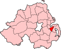
town inCounty Down ,Northern Ireland , about 10 kilometres (6 miles) south ofBelfast city centre. It had a population of 6,595 people in the 2001 Census.The original village formed where six roads and a river crossed, and is the site of the ancient Queen's Fort Rath. The road south from
Belfast (the A24) climbs out of a gap in theCastlereagh Hills , and splits at Carryduff, one fork (the A7) continuing toDownpatrick (viaSaintfield andCrossgar ), the other fork (A24) continuing viaBallynahinch to Newcastle towards Killkeel. In addition, the road westwards from theArds Peninsula ,Newtownards andComber (the B178) crosses here en route to Hillsborough in the west. All six roads cross the smallCarryduff River here (which flows northwards to eventually join theRiver Lagan atMinnowburn .The
townland s of Carryduff,Ballynagarrick andKillinure adjoin each other here, originally all farmland in a classicdrumlin landscape. Local churches built there include Immaculate Heart of Mary (Catholic) Church, Carryduff Presbyterian Church and St. Ignatius'Church of Ireland . Carryduff has twice been awarded the Best Kept Small Town by the Northern Ireland Amenity Council.History
The good road connections (note that Carryduff was never at any time connected to the Irish rail network) and proximity to Belfast made the town an ideal site for overspill development from the city in the 1960s. This period saw numerous housing developments (swallowing Queen's Fort Rath), the construction of the "Town and Country Shopping Centre", and Carryduff Primary School, leading into the 1970s with the building of the Killynure council estate. Ribbon development along one side of the northbound A24 took place adjacent to the Immaculate Heart of Mary
Catholic Church and St. Joseph's Primary School, with the Knockbracken Reservoir on the other side.The 1980s saw expansion continue, with Carryduff becoming a dormitory satellite town for Belfast commuters. Developments continued into the 1990s and included Carryduff Library,
Carryduff Shopping Centre , including shops such as Wellworths (now SuperValu and Ireland-wide stationery and book shopEason (previously NPO) and strangely, two Winemark stores across the road from each other. Numerous further housing developments have been erected on former green-field sites, as well as the Loughmoss Leisure Centre. These developments saw the Carryduff River placed inside a covered pipe for much of its journey through the town. Another big development of was the Brackenvale petrol station on the Saintfield Road, which has an Indian Restaurant, a McDonalds and a KFC opposite.Very little
green belt land now remains between Carryduff and the southern border of Belfast, the 1980s having seen the formerMatthew Stop Line breached.Fact|date=August 2008 Carryduff's original raison d'être as a focus of routes on the southern approach to Belfast has led to something of a transport problem, as the road network struggles to cope with commuter traffic, resulting in large amounts ofrush hour congestion . UrbanCitybus (Metro) routes did not extend out to Carryduff, leavingUlsterbus services from Belfast to Downpatrick and Newcastle as the only public transport.Culturally, as it moved beyond its farming roots in the latter half of the 20th century, Carryduff suffered somewhat from the classic suburban satellite syndrome, being rather devoid of interest in the field of the arts. No cinema, theatres or nightclubs existed in the town.
A few attempts have been made to revive the "community spirit" in Carryduff; some of the more notable ones have been the launch of "Carryduff Focus" - a local business directory with a few articles.
port
*Carryduff GAC [http://www.carryduffgac.com/] , based behind the new church in Carryduff (the biggest out of the three clubs)
*Annadale Hockey Club is based in Carryduff.
*Carryduff FC has long been established in Carryduff since its creation in 1992Demographics
The population of Carryduff on Census day (29th April 2001) was 6595 people. The demographic characteristics of the people living in Carryduff was as follows:
* 26.8% were aged under 16 years
* 14.1% were aged 60 and over
* the average age was 34.0 years (NI average age 35.8 years)
* 47.9% of the population were male and 52.1% were female
* 45.8% were from a Catholic Community Background
* 49.8% were from a 'Protestant and Other Christian (including Christian related)' Community Background
* 8.4% were born outside Northern Ireland
* 1.7% were from an ethnic group other than whiteFor more details see: [http://www.ninis.nisra.gov.uk/ NI Neighbourhood Information Service]
See also
*
List of villages in Northern Ireland
*List of towns in Northern Ireland
*Elim Pentecostal Church, Carryduff References
* [http://www.culturenorthernireland.org/town_Home.aspx?co=7&to=132&ca=0&sca=0&navID=1 Culture Northern Ireland]
Wikimedia Foundation. 2010.