- Darra, Queensland
-
Darra
Brisbane, Queensland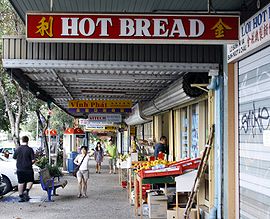
Shops in Darra.Population: 3,813 (2006 census)[1] Postcode: 4076 Location: 14 km (9 mi) from Brisbane GPO LGA: City of Brisbane State District: Electoral district of Inala
Electoral district of Mount OmmaneyFederal Division: Division of Oxley Suburbs around Darra: Mount Ommaney Seventeen Mile Rocks Oxley Sumner Darra Oxley Richlands Inala Oxley Darra is a Brisbane suburb known for its high migrant population. It is one of the older suburbs and lies about 14 kilometres southwest of Brisbane. The houses are mainly of the Queenslander style built in the 1940s and 1950s. The majority of blocks in Darra are large enough to be subdivided, which is becoming popular in the suburb, hence making room for more modern homes. In the last few years, a property developer bought a vast tract of vacant government land. As a result, there are now many new homes and townhouses built in Darra, which has increased its population and its geographical boundaries.
Contents
Location
The suburb is conveniently located on the Ipswich train line which provides an incentive for people to settle there, as travel to Brisbane is relatively fast and easy. The suburb is yet to reach its full potential.
Surrounding suburbs include Seventeen Mile Rocks, Oxley,Sinnamon Park, Sumner, Richlands and Mt Ommaney. Darra is right next door to the Centenary suburbs and conveniently located near the Mount Ommaney shopping centre, with its many retail and commercial facilities. The Centenary Freeway and the Ipswich Motorway provide convenient access to the Brisbane CBD.Darra also features a shopping centre in Monier Rd with Woolworths, a liquor store, hairdresser, chemist and post office.
Transport
Darra railway station provides access to regular Citytrain services to Brisbane, Ipswich and Rosewood via Ipswich. Darra railway station is set to become the main line out to Springfield Lakes.
There are also buses that travel to surrounding suburbs such as Inala and Mount Ommaney
Attractions
Darra has many Vietnamese restaurants and grocery stores. Opposite the railway station in Railway parade there are three Vietnamese grocery stores, and a Vietnamese/Chinese restaurant named Cam Ranh, colloquially known to locals as the "Welcome welcome my friend" restaurant. This is due to the restaurant owner's greeting and speech style. Nearby there are three other Vietnamese/Chinese restaurants. Situated in Darra now are a new sporting club featuring many indoor sports, plus a new Fernwood gymnasium in Bellwood St. These are both conveniently located not far from Darra railway station. In Monier Rd there is also the Monier Rd Hotel, a modern establishment which provides dining, bar and pokies. Up the road from there is Gardenway, famous for its nicnacs, and also a popular place for people to have coffee and lunch with friends.
Schools
Darra has two primary schools, one state and one Catholic private school ('Darra State School' and 'Our Lady of the Sacred Heart') . Both occupy blocks fronted by Darra Station Rd and Scotts rd, and both are conveniently located near the railway station. Because the suburb has two primary schools, it is becoming more popular with younger families moving to the area.
Urban planning
Overall plans include the further redevelopment of the industrial park, which should provide an injection of capital into the community and further upgrade local infrastructure and community facilities. The Brisbane City Council has been active in rejuvenating the streetscapes of the Darra suburb as well as neighbouring recreational and parkland facilities in Jindalee and Sinnamon Park.
Census data
According to the 2001 Census, 3,698 people living in the area with a median age of 33. Of all occupied private dwellings, 62% were either fully owned or being purchased; 30% were being rented. In 2006, 21.4% spoke Vietnamese,4.1% spoke Arabic, 2.5% spoke Samoan and 51.8% spoke only English with various other minority groups speaking other languages.
[2].
REIQ research shows that the median house price in the suburb for the financial year 2005-06 was $310,000.
See also
References
- ^ Australian Bureau of Statistics (25 October 2007). "Darra (Brisbane City) (State Suburb)". 2006 Census QuickStats. http://www.censusdata.abs.gov.au/ABSNavigation/prenav/LocationSearch?collection=Census&period=2006&areacode=SSC31167&producttype=QuickStats&breadcrumb=PL&action=401. Retrieved 2008-02-28.
- ^ http://www.censusdata.abs.gov.au/ABSNavigation/prenav/LocationSearch?locationLastSearchTerm=darra&locationSearchTerm=darra&newarea=305071167&submitbutton=View+QuickStats+%3E&mapdisplay=on&collection=Census&period=2006&areacode=305071167&geography=&method=Place+of+Usual+Residence&productlabel=&producttype=QuickStats&topic=&navmapdisplayed=true&javascript=true&breadcrumb=PL&topholder=0&leftholder=0¤taction=104&action=401&textversion=false&subaction=1
External links
Coordinates: 27°34′S 152°58′E / 27.567°S 152.967°E
Categories:- Suburbs of Brisbane

Wikimedia Foundation. 2010.