- Nundah, Queensland
-
Nundah
Brisbane, Queensland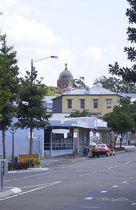
Population: 8,286 (2006)[1] Postcode: 4012 Area: 3.6 km² (1.4 sq mi) LGA: City of Brisbane,
Northgate WardState District: Clayfield, Nudgee Federal Division: Lilley Suburbs around Nundah: Wavell Heights Virginia Northgate Kedron Nundah Brisbane Airport Wooloowin Clayfield Hendra Nundah (previously called German Station) is an inner suburb in the city of Brisbane, Australia, located approximately 8 kilometers north-east of the Brisbane central business district,[2] in the local government area of the City of Brisbane.
Prior to European settlement, Nundah was inhabited by Aboriginal people from the Turrbul tribe. Nundah is primarily a residential suburb, which straddles Sandgate Road, one of the major arterial roads of Brisbane's north. It was first settled by Europeans in the mid-19th century, although the suburb remained primarily a rural area until it was connected to Brisbane via railway in the 1880s.[3] Originally considered a working-class suburb, the area has become gentrified in recent years, and today features a mix of traditional worker's cottages and modern high-density apartment blocks. It is close to the Centro Shopping Centre. The name "Nundah" means "chain of water holes" in the local Aboriginal dialect.[4] This name is probably a reference to the nearby natural water sources at Kedron Brook and the marshy areas formerly to the east of the suburb.[5]
Contents
Geography
Nundah is a mixed-density residential suburb, with some light industry and a commercial retail area concentrated on Sandgate Road. It is adjacent to the suburbs of Clayfield, Northgate and Wavell Heights, and is dominated by a large ridge that runs from the northwest to the southeast. The "Nundah Village" shopping district and Nundah State School are on this ridge, while the Nundah Tunnel bisects it along Sandgate Road.[6]
The suburb includes the locality and formerly distinct suburb of Toombul, which is centered in the south of Nundah, around Sandgate Road. Various facilities in Nundah are named after this locality, including the large shopping centre Centro Toombul, Toombul Bus Station and the Toombul Train Station.
Schulz Canal runs through Nundah, bisecting the Toombul Shopping Centre Carpark. The low elevation of the carpark makes it particularly susceptible to flash flooding during peak storm seasons - often claiming the cars of unwary shoppers inside the centre and those attempting to cross the Melton Road bridge. The estuary of the canal is a moderately popular recreational fishing spot.
History
Aboriginal History
Like most of Northern Brisbane,[7] the area around Nundah was dominated by the Turrbul tribe.[8] Their traditional coastal trade route passed through Nundah, near the modern-day Hedley Avenue. There are also many significant Aboriginal sites near Nundah, such as Dinah Island, which was reportedly the site of the last traditional Aboriginal burial in the Brisbane area.[8] There were a number of bora rings in the area, indicating that the Nundah area was densely populated by Aboriginal people before European settlers arrived.[9]
European Settlement
German Mission
 Memorial to the German Missionaries erected in 1938 for the area's centennial
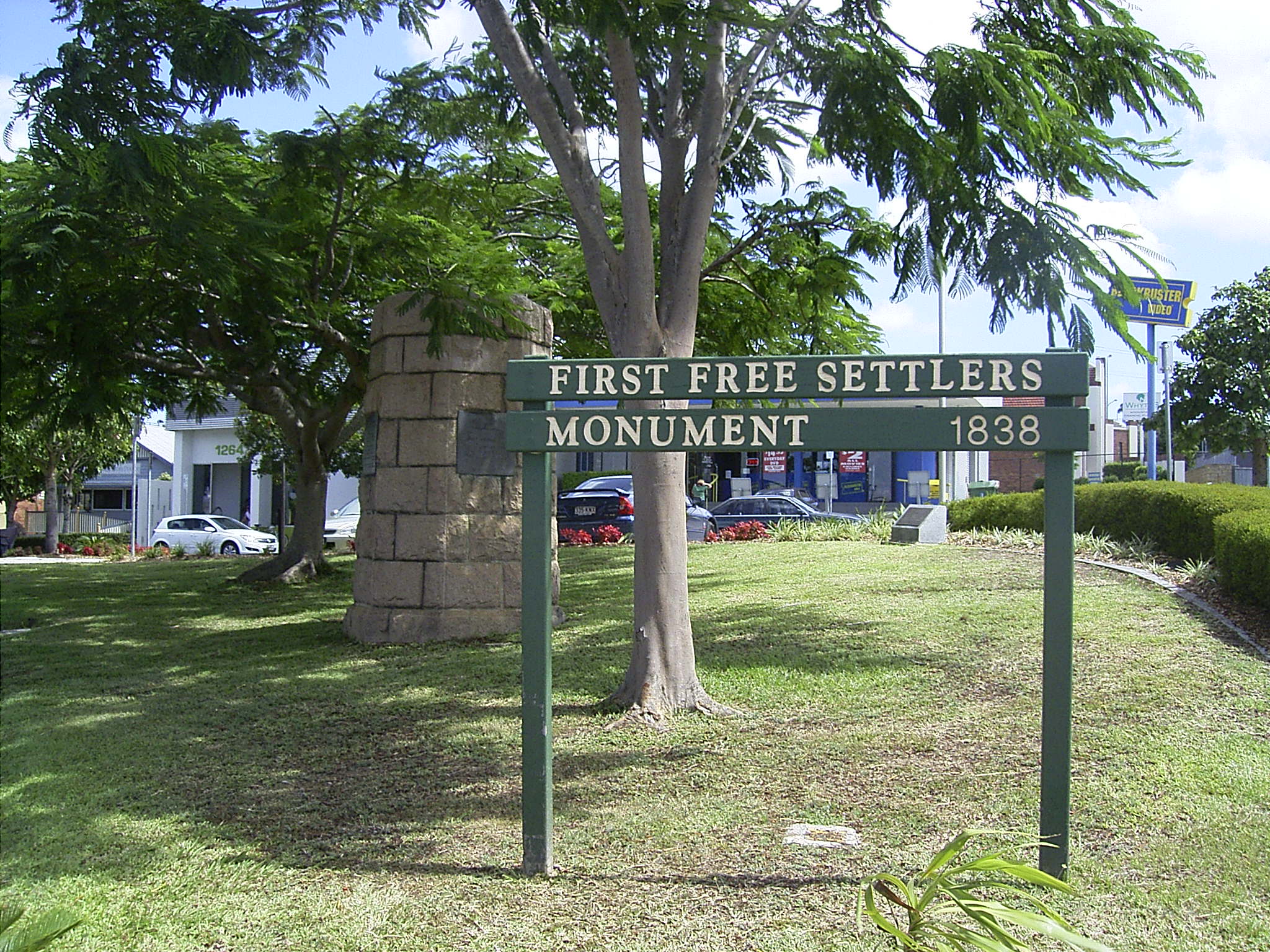
The first permanent European settlement in the area was a mission built in 1838 by German Lutheran missionaries,[10] under the guidance of Reverend Carl Wilhelm Schmidt and later Reverend Christoph Eipper with the aim of bringing Christianity to the local Aboriginal people.[11][12] They first called the area "Zion",[6] and the mission was located in the vicinity of the modern-day street "Walkers Way".[13] It later became "German Station". The explorer Dr. Ludwig Leichhardt visited the area in 1843, and spoke very highly of the mission, but despite this the mission met with limited success and was closed at the behest of the colonial government in 1846.[12] This first settlement is nonetheless commemorated with a monument at the corner of Sandgate Road and Wood Street unveiled in 1938 by the then Premier of Queensland William Forgan Smith. The names of these German settlers can be seen in the names of streets in Nundah and surrounding suburbs such as Rode Road and Gerler Road.
Growth of the Village of German Station
A prominent local citizen who contributed significantly to the development of the village of German Station was George Bridges (1820–1898). George and his young family immigrated from Wilstead, Bedfordshire, England to Queensland in 1852 aboard the "Marie Somes". In 1855, he acquired 64 acres (260,000 m2) of land north of Buckland Road and east of Sandgate Road for farming. However as Sandgate became an increasingly popular holiday destination, the increasing volume of coach traffic along Sandgate Road encouraged him to open a hotel, which became a popular stop being roughly half-way between Brisbane and Sandgate. The first hotel was called the Kedron Hotel but the third and longest-running hotel was known as the Kedron Brook Hotel and was located alongside Sandgate Road (now Bage St) on the SW corner of his property. Emboldened by the success of his hotel ventures, George Bridges looked for other commercial opportunities. He observed that Sandgate Road at that time did a dog-leg around the SW corner of his property (along Buckland Road) which forced traffic to travel up and over Donkin's Hill. So he created a short-cut across the SW corner of his property that avoided the hill, which was much appreciated by the travellers, allowing George Bridges to sell off parcels of land along this new unofficial piece of Sandgate Road to commercial enterprises, which serviced both the travellers and the local farming community. This unofficial short-cut grew into the Nundah Village shopping street that exists today and eventually became the official route of Sandgate Road. Around 1872, George and his wife Mary retired to Burpengary and began to progressively sell off the land of their German Station property as the village developed.
Creation of the Suburb of Nundah
German Station remained an agricultural area until the 1880s. In 1881, Queensland State Government purchased a strip of land across George Bridges's property to build a railway link between Brisbane and Sandgate. The railway opened in 1882 and resulted in a suburban residential construction boom on Brisbane's northside.[3] This urban sprawl was also encouraged by the Undue Subdivision of Land Prevention Act 1885, which mandated minimum lot sizes for new urban developments.[14] The village of German Station became known as a location where working-class families could obtain cheap housing on reasonably-sized lots not too far from the city. George Bridges sold off his remaining land for residential development in the new suburb.
A railway station called "German" was created in 1882 (again on land originally owned by George Bridges), because they wanted the station to be called "German Station" rather than "German Station Station".[15] However, six weeks after the railway station opened, it was renamed "Nundah", derived from the Aboriginal name for the area.[16] In 1888, the name of the Post Office was also changed to Nundah,[17] signalling the renaming of the new suburb. However, the name "German Station" persisted for many years. For example, the German Station National School did not become Nundah State School until 1896. For many years it was common to find references to "Nundah" with the annotation "formerly German Station" in newspapers and advertisements, until the name "Nundah" was well established.
In 1909, Surrey Street in Nundah became the site of the first public housing dwelling in Queensland.[18] In the early twentieth century, Nundah became a major suburban centre, due to its location on Sandgate Road, one of Brisbane's busiest arterial roads, and the adjacent Nundah railway station. Sandgate Road and nearby streets were lined with shops, pubs, cinemas and other commercial premises. Nundah was also the seat of Toombul Shire, which was absorbed into the City of Greater Brisbane in 1925.[19][20] The Toombul Shire Hall still exists as a community centre.[20]
In 1926, George Walker suggested a monument be built to mark the beginnings of Nundah, which was unveiled by the Queensland Governor Sir Leslie Orme Wilson on April 23, 1938 as part of the First Free Settlers' Centenary Celebrations. This First Free Settlers Monument is listed in the Queensland Heritage Register.
Decline of Nundah
Nundah's commercial precinct suffered a precipitous decline from the 1970s with the construction of the nearby Westfield Shoppingtown (Later Centro) Toombul shopping centre.[21] Increasing motor traffic along Sandgate Road also reduced Nundah's appeal as a shopping precinct as it was difficult to park. Gradually many shops closed, and those that opened in their place were often "low-class" establishments such as pawn brokers, charity stores etc. that were unappealing to most shoppers, driving them increasingly to shop at Toombul.
Renewal of Nundah
However, in 2001 a road tunnel was constructed under nearby Bage Street, diverting through traffic away from the suburban centre. There was considerable popular support[22] to name the road tunnel after George Bridges in recognition of his contribution to the development of the district and the fact that the tunnel was located on his original land holding. However, the local member Liddy Clark would not support it for fear it would offend the Aboriginal community. Instead the Queensland State Government proposed to honour George Bridges in some other way (but, as of 2009, this has not occurred).
In 2008 the Brisbane City Council suburban renewal programme has seen new art installations, cafés and commercial enterprises open in Nundah, creating a village-like atmosphere along the now-quiet Sandgate Road.[23] The suburb has now become popular among white collar workers seeking relatively inexpensive housing and apartments only a moderate distance from the Brisbane CBD. Since then, along with the rest of the city, housing prices in the area have skyrocketed, pricing most of the traditional working class out of the suburb.
Demographics
Over one third of Nundah households are families with children, while 41% are couples only. A further 20% are single parent families. 41% of dwellings in the area are stand-alone houses, while 45% are units. Many old timber homes in the area have been renovated, while modern townhouses and units have also been built which are generally rented and small. The median house price in Nundah for the 2004 calendar year was A$352,500.[24]
At the 2006 Australian Bureau of Statistics census, at least 73% of the population was born in Australia. Of the remainder, 5% were born in New Zealand, 4% in the United Kingdom, and just over 1% from the Philippines.[1]
As of 2010, Nundah has a large population of foreign migrants and refugees. Nundah is home to a large Indian population as well as many Muslims.
Transport
Due to its inner-northern location, there are a variety of options for transport within the suburb. Both the Nundah Citytrain station and the Toombul Citytrain station are located within the suburb. Both of these railway stations are on both the Caboolture Line and the Shorncliffe Line, giving both stations 15-minute frequencies throughout the day seven days a week. There are many council bus services that run through the area, including the 598/599 Great Circle Line.
The Nundah Bypass is a 285 metre long road tunnel, open to general traffic, that runs underneath the Nundah Village commercial area. Completed in 2001, it provides an alternative route to traffic travelling along Sandgate Road, allowing motorists to avoid the narrow streets of the village area, and reducing traffic congestion for local residents.[25]
Commerce
 Nundah Village shopping centre
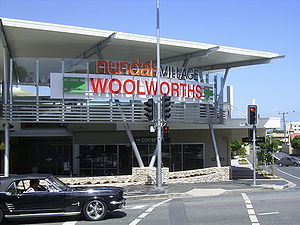
Nundah retails a traditional "shopping strip" commercial district, centered mainly along the section of Sandgate Road that has been bypassed by the Nundah Bypass.[25] There are plenty of cafes and specialty shops, as well as some medical facilities. There is also a small shopping centre anchored by a Woolworths supermarket, which was opened in mid-2007, containing over 200 parking spots, a Subway store, a Coffee Club, and numerous other small shops. Plans to relocate the Nundah Library into the Nundah Village district have been verified.[citation needed]
Politics
Nundah is in the federal electorate of Lilley.[26] The seat has been held by Wayne Swan of the Australian Labor Party since the 1998 federal election.[26] Swan's electoral office is in the suburb, in the commercial district on the corner of Sandgate and Buckland roads.[27] The suburb lies on the border between the state electorates of Clayfield (held by Liberal Tim Nicholls),[28][29] and Nudgee (held by Labor's Neil Roberts).[30][31] Locally, the suburb is part of the Northgate Ward, held by Labor's Kim Flesser.[32]
In earlier times, it was part of the Nundah electorate, one of the historical Electoral districts of Queensland.
Future development
Plans are under way to further change the Nundah Village area dramatically. As part of the Circa Nundah development, 3.5 hectares of Nundah will be redeveloped to include a medium-rise commercial office tower, retail, and apartments.[33] This development will also house the relocated Nundah Library. The development will span parts of Sandgate Road's east side, some southern parts of Station Street, and will cover most of Aspinall Street.
The development of the Airport Link tunnel, which will have its entrance just south of Toombul, will see travel times to the CBD reduced significantly.
Toombul District Cricket Club
The cricket club is situated on the corner of Duke Street and York Street, directly across Duke Street from Nundah Train Station. It covers 3.5 hectares, and is bordered by York Street, Duke Street, Melton Road and Jenner Street. It was active as a cricket club prior to the station being built in 1882, and is the oldest sports club in Queensland.
Toombul is one of the most successful clubs in the history of Queensland club cricket, with 19 First Grade Premierships in its history. The club supports 6 senior grades, from First grade to Sixth grade, Under 18's, as well as a comprehensive junior club.
Toombul is widely regarded as the most social cricket club in Brisbane, with its group of supporters, The Toombul Faithful (or simply The Faithful) made up of former and current players, turning out in numbers to support the club in semi finals and finals. This adds to the club's reputation as a formidable opposition, both through the calibre of players that play for the club, and the ferocious support dealt out by The Faithful on unwary oppositions.
The Toombul District Cricket Club and The Faithful have social ties with local businesses, particularly The Royal English Hotel and the Prince Of Wales Hotel, both in Nundah, The Bowler Bar in Fortitude Valley, and The Victory Hotel in the Brisbane CBD.
The song "Shimmer" by Fuel is a Toombul anthem, and is embraced as the unofficial song of the club by its players and supporters.
Notable players from Toombul over the years include Jeff Thomson, Ken Mackay, Colin McCool, Ron Oxenham, and Wally Grout.
People of Nundah
- George Bridges, (1820–1898) pioneer farmer and developer
- Thomas Bridges, (1853–1939) son of George Bridges, Member of the Legislative Assembly
- Bob Bax, legendary coach of The Norths Brisbane first grade rugby league team which is based out of Bishop Park, Nundah and formerly Oxenham Park, Nundah. Bax coached the Devils in five of their historical six successive premiership victories between 1959-64.
- Bill Knox, (1927–2001) Member of the Legislative Assembly, Treasurer of Queensland
An index to people mentioned in the book “From Pioneering Days: Nundah Northgate Virginia” by Nundah & Districts Historical Society Inc can be found here. While many of the people listed are residents of the district, some people may have had only a peripheral involvement with it.
Landmarks
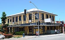 The Royal English Hotel
- Bishop Park - Home ground of the Norths Devils rugby league team in the Queensland Cup competition.
- Boyd Park - Grounds used by the Nundah State School
- Oxenham Park - Home of the Toombul District Cricket Club in the Queensland Cricket Association Grade competition, and contains the Ken MacKay and LaFrantz Ovals
- Centro Toombul Shopping Centre
- Nundah Criterium Bicycle Track - Located in Hedley Ave/Walkers Way Nundah, next to Albert Bishop Park and the Schultz Canal bikeway.
- Nundah Catholic Church
- Nundah Historic Cemetery - Contains the graves of many of the original settlers and their families.
- Nundah Library - Adjacent to the Sir William Knox Archives & Resource Centre.
- Nundah State School - Established 1865 as German Station National School
- Nundah Shopping Village
- Nundah Railway Station
- Prince of Wales Hotel
- Ross Park Skate and BMX Park
- Royal English Hotel
- Schulz Canal
- Sir William Knox Archives & Resource Centre - Behind the Nundah State Library.
- Toombul Railway Station
- Toombul Shire Hall - Available for hire.
- Tufnell Home Orphanage - Now the Tufnell Child Care Centre.
Parks
- Albert Bishop Park - Amelia Street, Hedley Avenue and Nudgee Road, adjoining Schulz Canal
- Boyd Park - Bage Street and Boyd, Park and Sandgate Roads
- Carew Street - Brook and Carew Streets
- Kalinga Park - Jackson and Kalinga Streets, Park Avenue and Sandgate Road, adjoining Schulz Canal
- Oxenham Park - Duke, Jenner and York Streets and Melton Road
- Plaisted Place - Cavendish, Flower and Maynard Streets
- Ross Park - Parkland Street and Sandgate Road, adjoining Schulz Canal
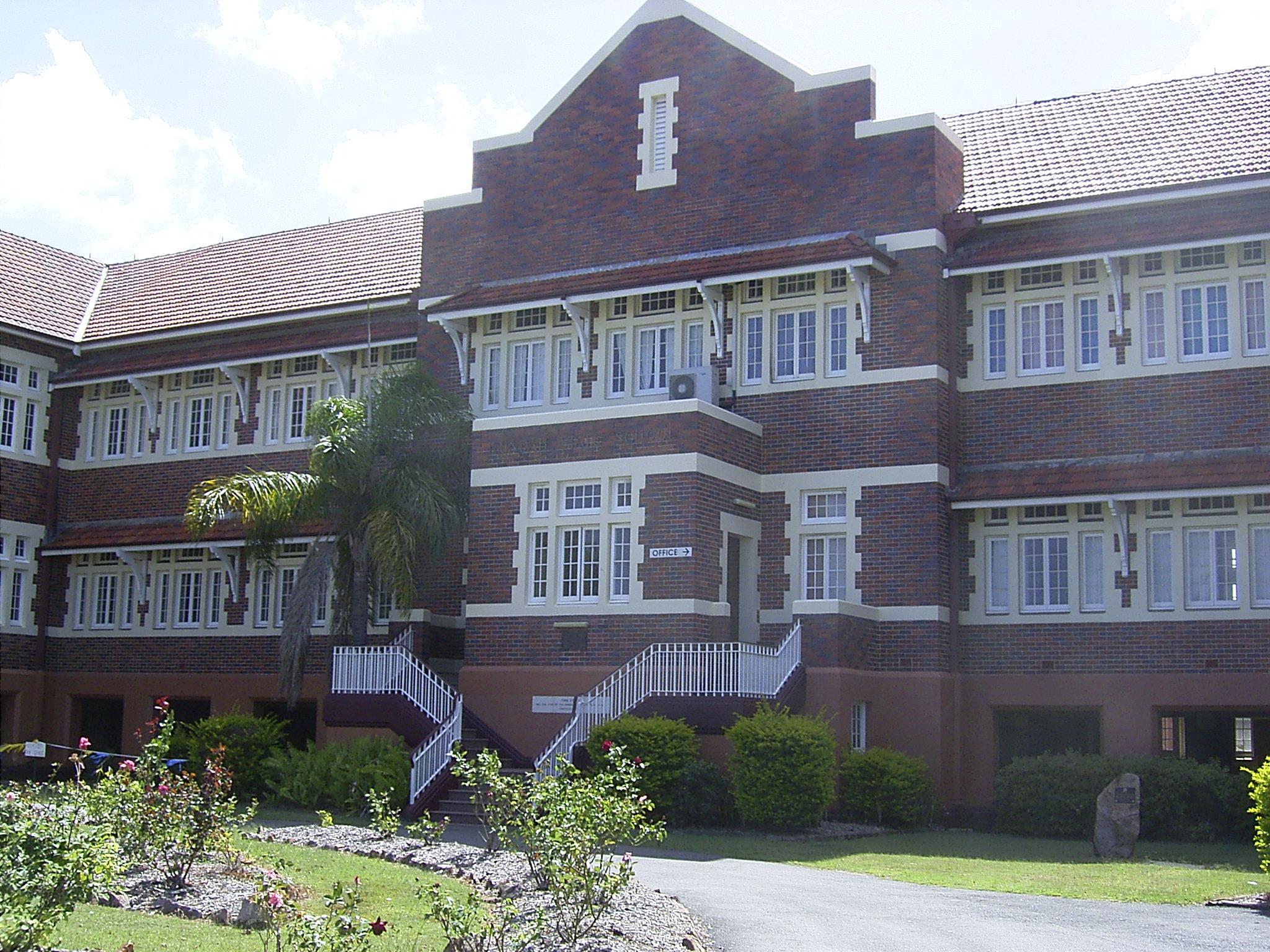
 Nundah State School
- Toombul Terrace - Bage, Gardner and Glenhill Streets, Hamson and Toombul Terraces and Royal Avenue
- Upton Street - Upton Street, off London Street
- Wood Street (Road Reserve) - Bage and Wood Streets and Sandgate Road
Educational institutions
- Mary MacKillop College (formerly Corpus Christi College)
- Nundah State School
- St. Joseph's Primary
Churches
Since the earliest days of the Zion's Hill mission, there have been a number of churches in the area. The Lutheran church continues to maintain a presence in the suburb, with a number of facilities, including St Paul's church, a childcare centre, and the Zion Retirement home clustered around the area near the corner of Buckland Road and Atthow Parade.
Other denominations also have a presence in the area, including the Catholic Church which has a combined church and girl's school on Bage Street. The Presbyterian, Baptist, Uniting and Anglican churches also have places of worship located within the suburb. Historically, the Methodist church and the Salvation Army also maintained churches in the area, although these are no longer active.
Community services
- Nundah Combined St John Ambulance Division
- Nundah-Northgate Scout Group (Scouts Australia) celebrating centenary in 2009
References
- ^ a b Australian Bureau of Statistics (25 October 2007). "Nundah (State Suburb)". 2006 Census QuickStats. http://www.censusdata.abs.gov.au/ABSNavigation/prenav/LocationSearch?collection=Census&period=2006&areacode=SSC31405&producttype=QuickStats&breadcrumb=PL&action=401. Retrieved 2008-01-26.
- ^ "Brisbane Suburb Home: Nundah". OurBrisbane. Archived from the original on 2007-10-11. http://web.archive.org/web/20071011090450/http://www.ourbrisbane.com/living/suburbs/nundah/home/. Retrieved 2008-01-26.
- ^ a b Madonna King (31 March 2006). "Local History - Sandgate". ABC Brisbane. abc.net.au. Archived from the original on 2008-01-07. http://web.archive.org/web/20080107173243/http://www.abc.net.au/brisbane/stories/s1605402.htm. Retrieved 2008-01-26.
- ^ "Origin of Brisbane Suburb Names". Our Indooroopilly. http://www.ourindooroopilly.com/oisuburbs.html. Retrieved 2007-01-29.
- ^ "Nundah and Toombul". Northgate Ward. Archived from the original on 2007-03-28. http://web.archive.org/web/20070328100251/http://www.northgateward.org/home_nundahandtoombul.html. Retrieved 2007-01-29.
- ^ a b "Bikeway to fill missing link". Northgate Ward. January 2003. http://www.northgateward.org/jan2003/home.html. Retrieved 2008-01-26.
- ^ "The North Pine Clan". Pine Rivers State High School. http://pineriversshs.eq.edu.au/pages/school/history/north_pine_clan.htm. Retrieved 2008-01-26.
- ^ a b "Historical Events". Nundah and Districts Historical Society. Archived from the original on 2007-09-27. http://web.archive.org/web/20070927151435/http://www.nundah.com/html/events.html. Retrieved 2007-06-23.
- ^ Tilston, John (2005). Meanjin to Brisvegas: Brisbane Comes of Age. p. 94. ISBN 978-1411652163.
- ^ These missionaries were:
- Peter Niquet - mason (married)
- August Rode - cabinet-maker (married)
- Johann Leopold Zillmann - blacksmith (married)
- Gottfried Haussmann - farmer (married)
- Wilhelm Hartenstein - weaver (married)
- Carl Franz - tailor
- Gottfried Wagner - shoemaker
- August Olbrecht - shoemaker
- Ludwig Doege - gardener
- Moritz Schneider - medical missionary (married)
- Carl Wilhelm Schmidt - ordained minister
- Christoph Eipper - ordained minister
- ^ Lack, Clem (1959). Triumph in the Tropics: An Historical Sketch of Queensland. Brisbane: Smith & Paterson.
- ^ a b Jupp, James (2002). The Australian People: An Encyclopedia of the Nation, its People and their Origins. Cambridge University Press. p. 369. ISBN 978-0521807890.
- ^ "Early History of Nundah". http://www.northgateward.org/home_earlyhistory.html. Retrieved 2007-01-29.
- ^ P.R. Skinner (March 2004). "When a little is a Lot: an architect’s view" (PDF). Queensland Planner. http://www.subtropicaldesign.bee.qut.edu.au/documents/SkinnerSmallLot.pdf. Retrieved 2008-01-26.
- ^ "[COMMUNICATED. A SCENE IN THE HOUSE."]. The Brisbane Courier (Qld. : 1864-1933) (Qld.: National Library of Australia): p. 7. 22 July 1882. http://nla.gov.au/nla.news-article3413052. Retrieved 6 March 2011.
- ^ From Pioneering Days, Nundah, Northgate, Virginia. Nundah & Districts Historical Society Inc, Brisbane. 2002.
- ^ "LOCAL GOVERNMENT.". The Brisbane Courier (Qld. : 1864-1933) (Qld.: National Library of Australia): p. 5. 8 March 1888. http://nla.gov.au/nla.news-article3469615. Retrieved 6 March 2011.
- ^ "Early 1900s: The Workers’ Dwellings Branch". Department of Housing. http://www.housing.qld.gov.au/about/doh/history/timeline/index.htm. Retrieved 2008-01-28.
- ^ "Toombul Shire Hall (Former)". Environmental Protection Agency. http://www.epa.qld.gov.au/projects/heritage/index.cgi?place=600272&back=1. Retrieved 2008-01-28.[dead link]
- ^ a b "History of Nundah". OurBrisbane. Archived from the original on 2007-09-22. http://web.archive.org/web/20070922114405/http://www.ourbrisbane.com/living/suburbs/nundah/history/. Retrieved 2008-01-28.
- ^ "Chapter Two - 1960 - 1970 - Determination, Drive, and Debentures" (PDF). Westfield Group. http://westfield.com/corporate/pdf/history/chapter2.pdf. Retrieved 2008-01-30.
- ^ Letter to Dept of Main Roads from Nundah & Districts Historical Society, 1 May 2001
- ^ Kim Flesser. "Another boost to Nundah's renewal". Northgate Ward. http://www.northgateward.org/news/page6.html. Retrieved 2008-01-30.
- ^ "Nundah". EMB Property. http://www.embproperty.com.au/index-tess1.php?ItemNo=1025. Retrieved 2008-01-26.
- ^ a b "Nundah Bypass". Arup. http://www.arup.com/australasia/project.cfm?pageid=1338. Retrieved 2008-02-03.
- ^ a b "Lilley". Australian Electoral Commission. http://www.aec.gov.au/profiles/l/lilley.htm. Retrieved 2008-01-28.
- ^ "Wayne Swan - Member for Lilley". Australian Labor Party. Archived from the original on 2008-01-26. http://web.archive.org/web/20080126110909/http://www.alp.org.au/people/qld/swan_wayne.php. Retrieved 2008-01-28.
- ^ "Clayfield" (PDF). Queensland Electoral Commission. http://www.ecq.qld.gov.au/profiles/Clayfield/Map.pdf. Retrieved 2008-01-28.
- ^ "Tim Nicholls MP". Queensland Coalition. http://qldcoalition.org.au/people/nicholls.aspx. Retrieved 2008-01-28.
- ^ "Nudgee" (PDF). Queensland Electoral Commission. http://www.ecq.qld.gov.au/profiles/Nudgee/Map.pdf. Retrieved 2008-01-28.
- ^ "ROBERTS, Neil - Nudgee". Queensland Labor Party. http://www.teambeattie.com/01_cms/details.asp?ID=130. Retrieved 2008-01-28.
- ^ "Cr Kim Flesser". Brisbane City Council. http://www.brisbane.qld.gov.au/BCC:STANDARD:1775852568:pc=PC_29. Retrieved 2008-01-28.[dead link]
- ^ "Circa Nundah is the latest project by Property Solutions". Property Solutions. http://www.circanundah.com.au/intro.html.
External links
- University of Queensland: Queensland Places:Nundah
- Nundah Virtual Village
- Nundah suburb information
- Statistical Portrait of Nundah
- A Short History of St. Pauls Lutheran Church, Nundah, Queensland
- Nundah-Northgate Scout Group
Coordinates: 27°24′07″S 153°03′58″E / 27.402°S 153.066°E
Categories:- Suburbs of Brisbane


Wikimedia Foundation. 2010.