- Kangaroo Point, Queensland
Infobox Australian Place | type = suburb
name = Kangaroo Point
city = Brisbane
state = qld
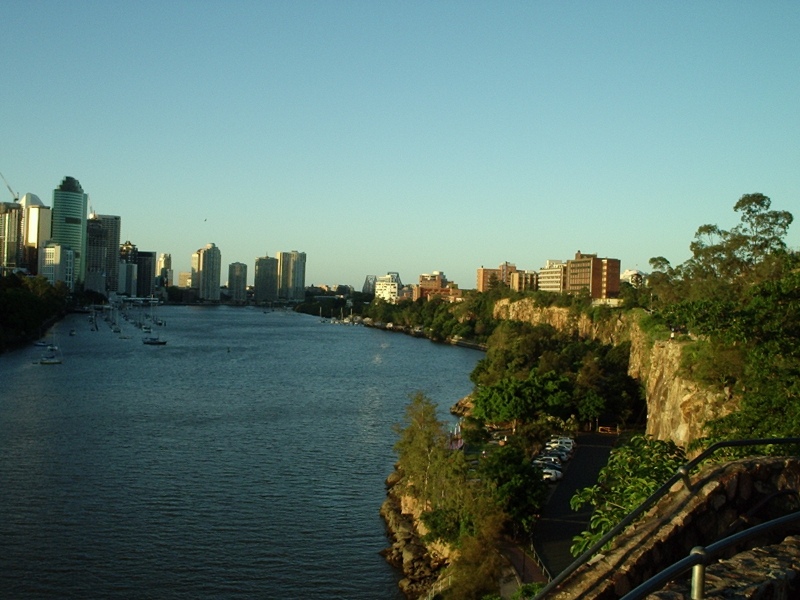
caption = Kangaroo Point (right), from the lookout on top of the cliffs
lga =Brisbane City Council ,
Central Ward
postcode = 4169
pop = 6,495 (2004) [ [http://www.abs.gov.au/AUSSTATS/abs@.nsf/Latestproducts/305051304Population/People12000-2004?opendocument&tabname=Summary&prodno=305051304&issue=2000-2004&num=&view= ABS Statistics for Kangaroo Point] ]
area = 1.3
stategov =
fedgov = Griffith
near-nw = Spring Hill
near-n = Fortitude Valley
near-ne = New Farm
near-w = Brisbane City
near-e = New Farm
near-sw = Woolloongabba
near-s = Woolloongabba
near-se = East Brisbane:"For other places named Kangaroo Point, seeKangaroo Point Kangaroo Point is a suburb of
Brisbane ,Queensland ,Australia located directly east across theBrisbane River from theBrisbane CBD .Geography
Kangaroo Point is located on a
peninsula formed of harderrhyolite rock which theBrisbane River flows around. On the northern tip of the peninsula the Story Bridge connects it to the central business district and the suburb of Fortitude Valley. The suburb of Woolloongabba is located to the south. The six-laned Main Street runs from Story Bridge to Woolloongabba. The landscape of Kangaroo Point is predominantly high rise apartments towards the tip of the peninsula while the other end is predominantly low-medium density apartments and houses.Attractions
Kangaroo Point is a popular recreation spot, conveniently close to the city and the South Bank Parklands. The
Kangaroo Point Cliffs , situated on the east bank of the city bend of the Brisbane River north of the Maritime Museum, opposite theBrisbane River Stage and theQueensland University of Technology at Gardens Point.The cliffs are a popular picnic,
rock climbing andabseiling site. The steepness of the cliffs was increased by quarrying operations which mined thevolcanic rock orrhyolite lava flows which form the cliffs. These lavas were deposited in theTertiary period about 30 million years ago and filled up an ancient river valley. They currently form the banks of the Brisbane River.The Story Bridge is a prominent landmark, and provides the main means of access to the north of Brisbane. Directly under the bridge is the Storey Bridge Hotel.
Transport
By Bus, The suburb is serviced by the South-East Busway transit line and buses along Main St and Shafstons Avenue.
By Road, Kangaroo Point residents rely on the
Story Bridge and Captain Cook Bridge for access to the north, and theSouth East Freeway for access to the south. Main Street connects the Story Bridge through the suburb to the South East Freeway. By Bicycle, paths run along theBrisbane River from South Bank to and over the Story Bridge. The bicycle paths are heavily used by cyclists, roller skaters and pedestrians.By Ferry, Citycats and ferries service the terminal near the peak of Kangaroo Point. Another terminal is situated near the mouth of Kangaroo Point, opposite the QUT Gardens Point campus side. It is currently used by ferries only.
Future Transport
A green bridge is proposed to the west to connect Kangaroo Point to the City and to the east to connect Kangaroo Point to Merthyr Road New Farm.
A busway tunnel is proposed to connect under Kangaroo Point Cliffs from the
Woolloongabba Station to the Botanic Gardens underground busway station and onto a new City underground bus loop.The M7 Clem Jones Tunnel, an underground toll road under construction, will have an connection on Shafston Avenue. It is scheduled for completion by the end of 2009 and will divert some traffic travelling through the suburb while providing an additional transport route to residents.
An extension to the rail line is proposed from South Bank station to the Gabba Cricket Grounds which would service residents close to the mouth of Kangaroo Point.
Population and Housing statistics
In the 2006
Australian Bureau of Statistics Census of Population and Housing, the population of the Kangaroo Point postcode area was 6,868 people, in an area of 1.3 square kilometres. The population was 48.9% females and 51.1% males. It has one of the city's highest proportion of residents living in flats, units or apartments (80.7%). Residents in stand alone houses make up only 14% of the population. Further to this, 51.1% are renters while only 14.9% fully own their dwelling.According to REIQ, the median house price in Kangaroo Point for the calendar year 2006 was $513,000.
Education
Situated in Kangaroo Point is St Josephs Primary School which offers private schooling from grades 1 to 7. Although the suburb has no public schools to call its own, it is in close proximity to East Brisbane State School. For secondary/late primary school year entrancing, Kangaroo Point is in close proximity to St Laurence’s College, Anglican Church Grammar, Sommerville House, Brisbane State High School and Villanova College. For tertiary studies, Kangaroo Point is host to campuses of Southbank Institute of TAFE and Shafston University. Directly across the river from the cliffs is the Queensland University of Technology (Gardens Point campus).
History
Before British settlement, Kangaroo Point was home to the Coorparoo
Indigenous Australian tribe .It is one of the earliest suburbs settled in in Brisbane and subsequently, is one of Brisbane's oldest suburbs, rich in history and character.
For many years the suburb was dominated by the factories of heavy engineering businesses, particularly those involved in the maritime industry, such as Evans Deakin, Buzzacott & Co and Evans Anderson & Phelan. The last ships built by Evans Deakin at their dry dock on the eastern side of the peninsula were completed in 1980s and the company vacated the site, with it later being redeveloped for high-rise accommodation.
Stone was quarried from the Cliffs and used as building material
Until the 1930s Evans Anderson & Phelan built steam locomotives at their Kangaroo Point works for Queensland Railways, however their works were not located near a railway, so the completed locos were delivered along Main Street on temporary track.
Until the federation of the Australian colonies in
1901 , the Queensland Navy's main storage facility was located in the suburb. The first ship-based radio transmission in Australia was made between the "HMAS Gayundah" and the buildings in1903 . The naval stores buildings were occupied by the Royal Australian Navy until1959 , and then by the Australian Army until1984 . The heritage-listed buildings are now used by an adventure company focussing on river activities and rock climbing.Trams operated by the
Brisbane City Council linked the suburb with Fortitude Valley via the Story Bridge from1953 to1969 , running along Main Street fromWoolloongabba and other eastern suburbs.References
*Information on the naval stores drawn from the Queensland Heritage Register at:http://www.epa.qld.gov.au/projects/heritage/index.cgi?place=600239&back=1
External links
* [http://www.kangaroopoint.net Kangaroo Point info]
* [http://www.apartmentreviews.com.au/city_brisbane_kangaroopoint.htm Kangaroo Point apartments]
Wikimedia Foundation. 2010.