- Coorparoo, Queensland
-
Coorparoo
Brisbane, Queensland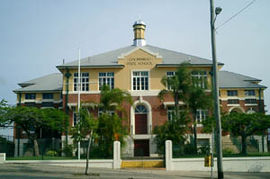
Coorparoo Primary SchoolPopulation: 13243 (2001 census) Postcode: 4151 Area: 5.3 km² (2.0 sq mi) Location: 4 km (2 mi) from Brisbane LGA: City of Brisbane State District: Greenslopes Federal Division: Griffith Suburbs around Coorparoo: East Brisbane Norman Park Morningside East Brisbane Coorparoo Camp Hill Greenslopes Holland Park Camp Hill Coorparoo is a southern suburb of Brisbane, Queensland, Australia, located approximately four kilometres from the city. Surrounding suburbs include Camp Hill, Holland Park, Greenslopes, East Brisbane, Norman Park and Seven Hills.
Contents
Aboriginal history
The Coorparoo Clan lived south of the Brisbane River and generally camped along creeks. Their name comes from Kulpurum, which was the word for Norman Creek or a tributary of it. They continued to occupy watercourse campsites after white settlement, but other clans from the region began to move into South Brisbane.
In 1846 there were reports[by whom?] of Aborigines raiding produce along Norman Creek. In 1853, there was a fight between Ningy Ningy, Bribie Island, Amity Point, and Logan peoples at Norman Creek. A visitor in 1855 reported many camps and fishing spots between Stones Corner and the mouth of Norman Creek. In 1959 an eighty-year-old woman told of frequent corroborees on the banks of the creek in Norman Park. Corroborees were also held at a little creek that crossed Norfolk Street.
Urban development
Coorparoo was named by the residents at a public meeting on 22 March 1875. The name Coorparoo comes from the Aboriginal name for Norman Creek.[1] This had been translated as both place of the mosquito and peaceful dove. The Shire of Coorparoo was formally proclaimed in 1888.
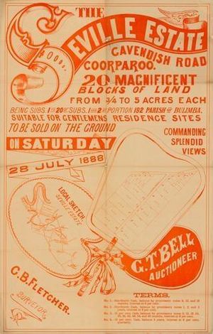 Estate map of the Seville Estate, Cavendish Road, Coorparoo, Brisbane, Queensland, 1888 .
On 17 June 1856, ten farms were sold from the Parish of Bulimba near Stones Corner. Investors bought all but two of them. The next year James Warner surveyed land on the other side of the road for a second land auction.
Samuel Stevens donated two acres of his property near the junction of Cavendish and Old Cleveland Roads for use of a school. He declined the offer of naming the area "Steven's Town" and on 22 March 1875, a meeting of local residents at the Wecker's house resolved that the 'name of the locality, together with the proposed primary school, should be Coorparoo'.
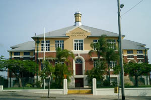
In 1876, the Coorparoo State School was opened and Frederick Robinson began offering public transport in a wagonette from Coorparoo Junction to Victoria Bridge. The 1880s land boom was a spur to profit from land. John Black was the first to subdivide land in the area in 1882 and later a variety of subdivisions were offered to the public. The construction of the bridge at Stanley Street (1886) and the development of the Stanley Bridge Estate made the area more attractive to purchasers. In 1887 the tramway was extended to Buranda, putting the western end of Coorparoo close to tram travel.
Coorparoo had been part of the Bulimba Divisional Boards since 1879. However, in 1888, as a result of dissatisfaction with this situation, a petition was taken and Coorparoo Shire was created. A bridge was built at Burnetts Swamp (Stones Corner) and important road improvements took place. Development was taking off. In 1889 there were 2,500 people in the shire.
The floods of 1889 and 1893 hit the low-lying areas of Coorparoo. The flooding combined with the 1890s depression slowed development in the area. In 1900 there were actually fewer houses than there had been ten years earlier. The settlement was dense from Stones Corner to Kirkland Avenue (originally named Wecker Street but it was changed in 1914 in the wake of anti-German sentiment), but further out it was mainly bush with a few isolated farms and houses. The only major industry was the brickworks of Abraham James at St Leonards Street, which employed eighty men in the 1880s.
After World War I, land prices increased as property sales boomed. Coorparoo did not really begin to expand again until the tram service was extended to Stones Corner in 1902 and Coorparoo Junction in 1915. The number of houses increased from 613 in 1911 to 1,467 ten years later. Development in Coorparoo had taken off.
Sports
Coorparoo is home of the Eastern Suburbs District Rugby League Football Club who play their home games at Langlands Park. Langlands Park regularly hosts training sessions for the Queensland and Australian Rugby League teams when they are playing in Brisbane.
The Brisbane Lions train during the week at Giffin Park, also in Coorparoo.
 Brisbane Central Business District viewed from Upper Cornwall Street, Coorparoo.
Landmarks
Coorparoo has a range of distinctive homes, buildings and sites of interest, including:
- Spanish Mission Revival homes along Cavendish Road. This was a popular inter-war house style introduced from California.
- Ridgelands (1880s), built for the Blundell family
- Cardington (1880s) located at the corner of Norfolk Street and Cavendish Road. This residence was built by Thomas Howling who had purchased the allotments from early settler George Harden.
- Barston Place (1880) on Norfolk Street, built for Scottish born James Burstall and named after his birthplace.
- Coorparoo Shire Hall (1892) located at the corner of Cavendish Road and Halstead Street. The building is now owned by the Coorparoo RSL Club and is now known as the Coorparoo School of Arts.
- Restored Tram Post located at the corner of Old Cleveland and Cavendish Roads.
- Hatherton (1886). This elite residence was built for Reubin Nicklin who previously residence was called Langlands. Reubin and his wife Jane were drowned in the RMS Quetta disaster in 1890. The house has subsequently been extensively renovated and changed and is known as the “Queen Alexandra Home” having been used as a Methodist Home for children, teaching classrooms for the local TAFE College and more recently as a community centre.
- Chatsworth (1888), built for William Evans who worked at Stewarts of Stones Corner. Chatsworth Road is named after this residence.
- Langlands (1883), built for Reubin Nicklin. This building is located in the grounds of the present Villanova College and is the oldest surviving masonry residence in Coorparoo.
- Cavendish Road
- Kirkland House Grand Colonial Queenslander (1883), built in circa 1880, this grand colonial Queenslander located on Kirkland Avenune is one of the oldest restorated houses that wrotes a history in Coorparoo.
- Kirkland Avenue. An affluent tree lined street offering sweeping panoramic views of the Brisbane CBD.
References
- ^ "From the News of 60 Years Ago.". The Queenslander (Brisbane, Qld. : 1866 - 1939) (Brisbane, Qld.: National Library of Australia): p. 51. 27 February 1936. http://nla.gov.au/nla.news-article23381618. Retrieved 13 September 2011.
External links
- BRISbites: Suburban Sites (History)
- ourbrisbane.com website - Coorparoo section
- University of Queensland: Queensland Places: Coorparoo and Coorparoo Shire
- Coorparoo Uniting Church history - founded 1886
Coordinates: 27°30′04″S 153°03′43″E / 27.501°S 153.062°E
Categories:- Suburbs of Brisbane
- Australian Aboriginal placenames


Wikimedia Foundation. 2010.