- Brisbane River
Infobox River | river_name = Brisbane River
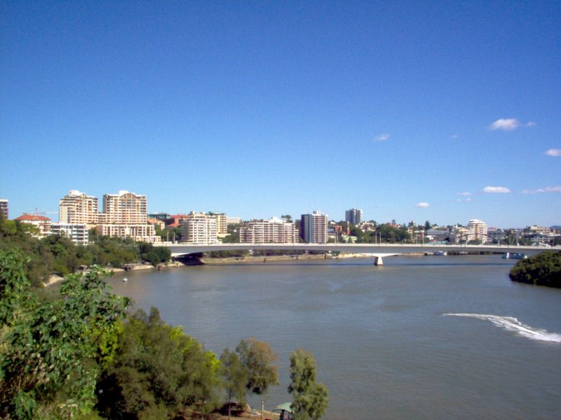
caption = Captain Cook Bridge from Kangaroo Point Lookout
origin =Conondale Range
basin_countries =Australia
length = 344 km
watershed = 13,600 km²The Brisbane River is situated in southeast
Queensland ,Australia , and flows through the city ofBrisbane , before emptying intoMoreton Bay . The river is dammed by theWivenhoe Dam , forming Lake Wivenhoe, the main water supply for Brisbane. The river was named after the Governor of New South WalesThomas Brisbane by the explorerJohn Oxley in 1823.The
CityCat ferry service collects and delivers passengers along the inner-city reaches of the river. ThePort of Brisbane manages the movement of larger vessels into the river from the bay.History
Before European settlement, the Brisbane River was a vital food source for the aboriginal people of the
Turrbal Nation. The Turrbal people were a fishing people. The river was also important to the Turrbal people for spiritual and recreational activities.Four European
navigators , namelyCaptain Cook ,Matthew Flinders ,John Bingle andWilliam Edwardson , all visited Moreton Bay but they failed to discover the river. Three castaways who were caught in a gale and blown off course all the way fromSydney toMoreton Island were found by John Oxley while he was surveying the east coast for a new penal settlement. They had previously wandered the area, walking along the river up to Oxley Creek.On the
2 December 1823 , Oxley and his crew, including two of the castaways, Pamphlett and Finnegan, entered the river and sailed upstream as far as present-day Goodna. [McLeod, p. 191.] Oxley noted the abundantfish and tallpine tree s. Early European explorers marvelled at the sheer natural beauty they witnessed while travelling up the lower reaches.Reports by early European explorers such as Allan Cunningham and Oxley indicate rainforest once fringed the Brisbane River and its major tributaries, especially on the broader floodplains such as St. Lucia and Seventeen Mile Rock. The coastal lowlands were extensively vegetated with
Melaleuca woodlands in low lying, poorly drained coastal areas. When first described by Europeans, the lower reaches of the Brisbane River were fringed by a mosaic of open forest, closed forest and rainforest. [Young, 1990 in Task M2 State of the Brisbane River and Moreton Bay and Waterways - Gutteridge, Haskins & Davey Pty Ltd, p. 6 - 8 1996]In the same year of 1823, the river was named after Sir Thomas Brisbane, the then Governor of New South Wales.
Upon the establishment of a local settlement in 1824, other explorers such as Allan Cunningham,
Patrick Logan and Major Edmund Lockyer made expeditions and surveys further upstream, and, in 1825, the Moreton Bay penal colony at Redcliffe relocated to North Quay. [McLeod, p. 192.]The first small private wharves were built on the river in about 1848. [McLeod, p. 197.] and the once popular, shark-proof river baths were first built in 1857 at Kangaroo Point. [Longhurst, p. 7.]
From 1862 the Brisbane River has been dredged for navigation purposes. [Wayne Erskine. 1990. "Environmental Impacts of sand and gravel extraction on river systems". In Peter Davie, Errol Stock, Darryl Low Choy (Ed.), The Brisbane river: a source-book for the future. pp. 295 - 302. Australian Littoral Society in association with the Queensland Museum.] Throughout much of the 20th century large quantities of
sand andgravel were extracted from the estuary of the river. Since the rate of materials being deposited is not as high as that which was removed, the river has acted as a subaqueous mine.In 1866 there was a breakwater built at the junction of the Bremer and Brisbane rivers that was designed to stop shingle from blocking the access to the Bremer's boat channel. The first pile light using
kerosene was built in 1882. [McLeod, p. 198.] Thesteel framed light also served as an early portsignal station .20th century
For some time the growth and settlement of Brisbane has adversely impacted the Brisbane River. By 1928 the water quality had deteriorated to the point where several
public bath s had to cease sourcing water from the river. [Longhurst, p. 3.]Even up to the 1930s, the water was very clear, with reports of people seeing the river bed 5 or 6m below the surface. In the middle tidal reaches today, visibility is about 0.2m. [Young, 1990 in Task M2 State of the Brisbane River and Moreton Bay and Waterways - Gutteridge, Haskins & Davey Pty Ltd, p. 6 - 2 1996] As Brisbane grew, the river became a handy open sewer and waste dump. The banks were cleared of timber and introduced animals rapidly changed the river's ecology. [Longhurst, p. 6.]
On the 25 March 1941, a USA goodwill
flotilla arrived in the city docking at wharves along the River. [Longhurst, p. 25.]1987 was proclaimed the "Year of the River" by the
Lord Mayor of Brisbane at the time,Sallyanne Atkinson .Navigation
There has been much dredging and widening work done over the years to allow ships to transport
cargo to and from Brisbane. The river has served as an important carriageway between Brisbane and Ipswich before arailway linking the towns was built in 1875. [McLeod, p. 192.] By early 1825buoy s were being laid along the South Passage and shortly after that the first pilots were commissioned to guide ships entering from Moreton Bay and another service for those travelling upstream. [McLeod, p. 196.] Flying boats used the waters of the river in Pinkenba, to take-off for domestic and international destinations in the 1930s. [Longhurst, p. 20.]The river depth was progressively increased and narrow points widened to allow larger vessels into the river and further upstream. For navigation and safety reasons the Seventeen Mile Rocks were completely removed in 1965 after numerous partially successful attempts in the past. The northern river bank at the mouth of the river has undergone reclamation projects over the years, especially in the suburbs of Hamilton and Pinkenba. More recently, extensive port facilities have been constructed on Fisherman's Island which has also seen significant land reclamation into the bay.
Early rivers crossings were made using small oared boat ferries, beginning in 1843 [Longhurst, p. 5.] , followed by steam ferries. In 1865 the first Victoria Bridge, later destroyed in a flood, was built across the river. Professor Hawken of the
University of Queensland undertook a study in 1914 to identify the future crossing points for the river.Historically, the Brisbane River contained upstream bars and shallows and has a natural tidal limit of only 16km. The current tidal limit now extends 85km upstream due to continual channel dredging. [Liz O’Brien, Paul Maxwell, Ivan Holland, Angela Grice and Dieter Tracey ‘Tidal Brisbane River’ Chapter 12 in State of South-east Queensland Waterways Report 2001 Moreton Bay Waterways and Catchments Partnership, p.75]
Course
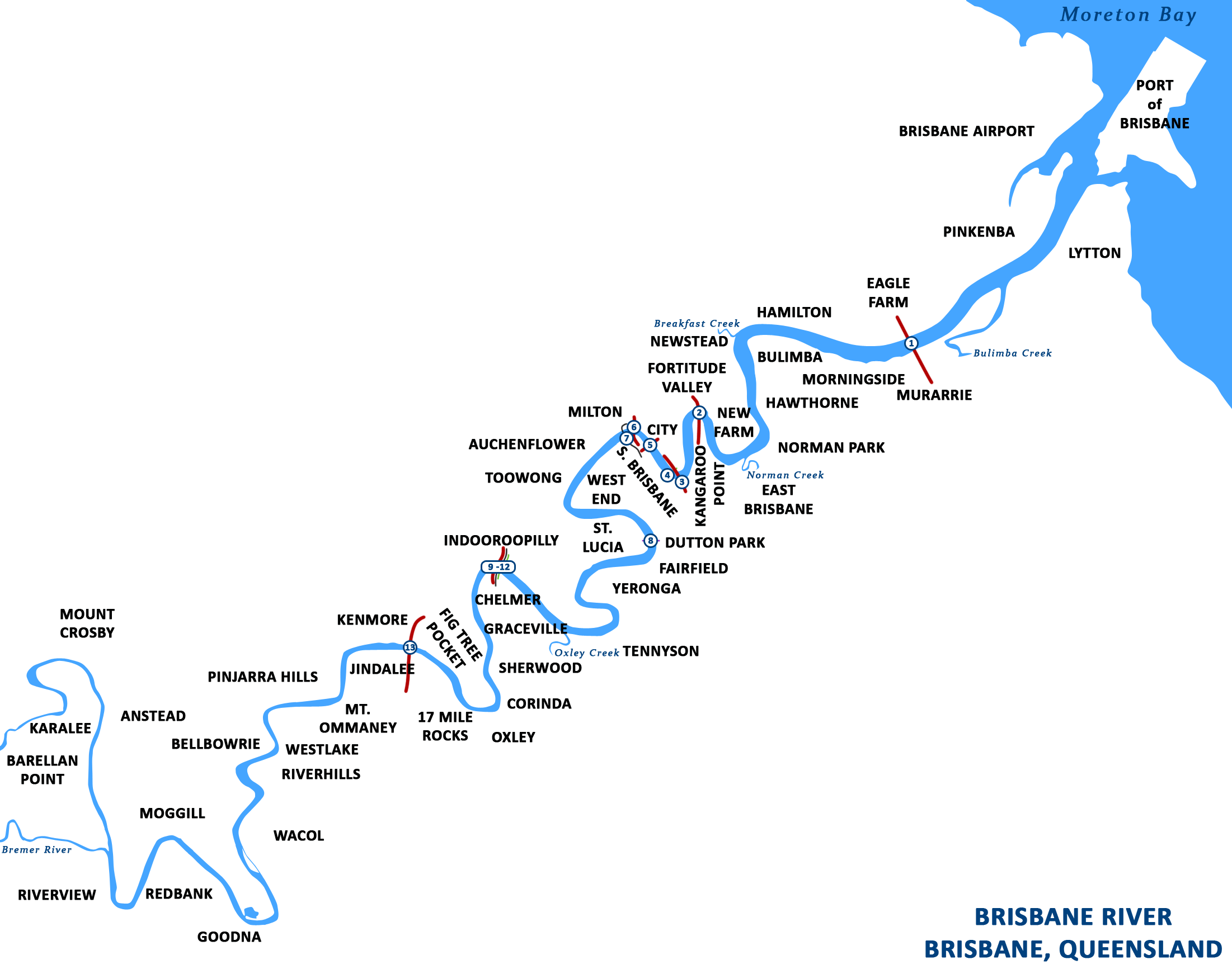
thumb|250px|right|Course of the lower reaches of the Brisbane River from Ipswich to Moreton Bay. ">
Legend
legend|#932ec2|Brisbane River's source is located in the
Conondale Range , east of Kingaroy. It then makes its way south, past Mount Stanley, and townships including Moore and Toogoolawah before joining with the Stanley River, just south of Somerset Dam. The river runs from there into Lake Wivenhoe, created by the Wivenhoe Dam. Beyond the dam, the river meanders eastward, meeting the Bremer River near Ipswich, then making its way through Brisbane's western suburbs, including Jindalee, Indooroopilly and Toowong. Through the city, the river is travelled upon byCityCat s, winding its way through the city centre. The Brisbane River then flows through thePort of Brisbane area and out intoMoreton Bay .Kangaroo Point Cliffs
On the southern side of the river, opposite Gardens Point, are the
Kangaroo Point Cliffs . The Kangaroo Point Cliffs were created by a quarrying operation that according to Allan Cunninghams' Field Book, was underway prior to 1829 when he observed a "stone wharf presumably used for landing the blocks of stone ferried across the river for the construction of buildings in the settlement" this was in the vicinity of Edward Street ferry terminal. Thevolcanic rock orrhyolite lava flows which form the cliffs were deposited in theTertiary period about 30 million years ago and filled up an ancient river valley. They currently form the banks of the Brisbane River.Tributaries
The following major tributaries flow into the Brisbane River from the north; Breakfast Creek, Moggill Creek and the Stanley River
On the southside Bulimba Creek,
Norman Creek , Oxley Creek, Bremer River and Lockyer Creek waterways enter the Brisbane River.The following smaller creeks also flow into the river; Cressbrook Creek, Cooyar Creek, Cubberla Creek, Wolston Creek, Woogaroo Creek, Goodna Creek, Six Mile Creek, Bundamba Creek, Pullen Pullen Creek and Kholo Creek.
Bridges
Currently the Brisbane River is crossed by 13 major bridges, including the historic Story Bridge and the tolled Gateway Bridge. There are two other major bridges upstream west of Brisbane, on the
D'Aguilar Highway and theBrisbane Valley Highway .Brisbane Riverwalk
The
Brisbane City Council has been developing a network ofriverwalk pavements along the banks of the Brisbane River. [ [http://www.brisbane.qld.gov.au/BCC:STANDARD:1840137411:pc=PC_1217 Brisbane Riverwalk] ]Jim Soorley , a former mayor of Brisbane, encouraged serious investment into the quality and capacity of the Brisbane riverwalk. An interesting section is the floating walkway between the Story Bridge and Merthyr Street New Farm. Brisbane City planners require many developers of formerly private riverfront blocks to create new sections of the Brisbane Riverwalk that are accessible to the public.Floods
The Brisbane River floods frequently, although the occurrence and magnitude of flooding has diminished following the construction of the
Wivenhoe Dam on the upper reaches of the River.Past floods have resulted in both deepening and reduction in river depth, creation of new
sand bank s andshoal s as well as increased transport of suspended sediment from upstream. Before the invention of moderndredging techniques thesediment deposited by flooding createdhazard s to ships navigating the river. Even medium sized vessels no longer travel up the Brisbane River beyond the city reach, and dredging of the upper reaches has ceased, allowing the river to recover substantially from the fine silt dislodged by gravel and sand extraction.Significant floods have occurred several times since the European settlement of Brisbane. The most significant of these events was the
1974 Brisbane Flood . Notable instances of flooding include:*
14 January 1841 (Highest flood level to date)
* March 1890
* February 1893, a sequence of flood peaks over some three weeks saw the highest recorded flood level in the Brisbanecentral business district . Seven lives were lost in the Eclipse Colliery at North Ipswich as a direct result of the flooding. Several other lives were lost to drownings.
* February 1931
*27 January 1974 (Largest flood to affect Brisbane City in the 20th Century).Flooding along the Brisbane River has the potential to be devastating. For much of the river's length its banks are relatively high, but topped by a broad plain. The river's sinuous course means that flood waters from upstream cannot be quickly discharged into Moreton Bay. Thus higher than normal flows cause river levels to rise rapidly and once the top of the banks are breached the floodwaters can spread over wide areas of the city.
Environmental concerns
During the 1800s and early 20th century, the river's surface was periodically choked by large swathes of the noxious weed known as
water hyacinth . The plant was originally imported from South America. [cite book |title=Brisbane's Western Suburbs: our heritage in focus |last=Meadows |first=Jane |authorlink= |coauthors= |year=1994 |publisher=State Library of Queensland Foundation |location= |isbn=0724260773 |pages=87 ]Environmentally, the river is in a poor condition and has been so for many years. The major causes of
pollution are excess nutrients,hydrocarbons ,pesticides andbacteria which become concentrated in the river and itssediment after flowing off surrounding lands. This river is also considered too murky and it is not recommended to swim in its waters. [Craig Johnstone. (July 22, 1995). "How we're slowly killing our river". "The Courier-Mail - Weekend" p. 1]Historically, the river was actively dredged by
Boral Sands Inc, ostensibly to make the river navigable. The constant extraction of river bed material by dredges has had considerable effect on the river. These impacts include increased turbidity, bed and bank erosion and changes in tidal hydraulics. The tidal nature of the river and the generally muddy nature of the sands removed by dredging created a woefully sludgy clayey sediment load in the river which did not clear. The efficacy of dredging the river upstream of the city reach to make it "navigable" was always in doubt, and the effect of the artificial sediment load in Moreton Bay grew to concern environmentalists worried that sediment was choking sea grass paddocks which were grazing territory fordugong . In a meeting concerning the matter in October 1996, including two State Government Ministers and three Mayors, an agreement to cease the dredging of sand and gravel from the river by September 30, 1997 was formed. Boral Resources Pty. Ltd. resisted the agreement, but ultimately all dredging was stopped by the agreed date.The river has several important ecological areas where remnant populations of
mangrove s exist; these include areas around drainage culverts, in Breakfast Creek, New Farm, a small preserve at the city bend, near theQueensland University of Technology and around the shipping terminals at the river's terminus into Moreton Bay.These mangroves have recently become classified as protected
nature reserve s.Brisbane River Cod
The freshwater reaches of the Brisbane River once supported a unique species of cod, similar to
Murray cod and closely related toeastern freshwater cod . Unfortunately this unique native fish became extinct somewhere between the 1930s and 1950's due to habitat degradation and overfishing. The river has been restocked with cod from the Mary River.Events
The Brisbane River hosts numerous events including the River"festival", River"fire" and the
Brisbane River Classic fishing competition. Many schools and clubs use the river to conduct rowing regattas on Milton Reach. Sailing regattas are also held on this reach as well as the Hamilton reach.ee also
*
Brisbane River Stage
*Pinkenba Wharf Citations
References
* Department of Harbours and Marine 1986 "Harbours and Marine "Port and Harbour Development in Queensland from 1824 to 1985" pp. 25 Queensland Government Department of Harbours and Marine
* J. G. Steele 1975 "Brisbane Town in Convict Days 1824-42" pp. 118 University of Queensland Press
*Longhurst, Robert; William Douglas. "The Brisbane River: A pictoral history". Brisbane, W.D. Incorporated Pty. Ltd.
*McLeod, G Roderick (1990). "Some aspects of the History of the Brisbane River". In Peter Davie, Errol Stock, Darryl Low Choy (Ed.), "The Brisbane River: a source-book for the future", Australian Littoral Society in association with theQueensland Museum .External links
* [http://www.ourindooroopilly.com/brisbane-river-map.html Historical Brisbane River Map]
* [http://www.bom.gov.au/hydro/flood/qld/fld_history/brisbane_history.shtml History of Brisbane flooding] — Bureau of Meteorology official website
* [http://www.brisbane.qld.gov.au/BCC:STANDARD:1576302065:pc=PC_1216 Brisbane Riverwalk Map]
* [http://www.nativefish.asn.au/cod.html Murray Cod]
* [http://enc.slq.qld.gov.au/logicrouter/servlet/LogicRouter?PAGE=object&OUTPUTXSL=object_enc36ui.xslt&pm_RC=REPOSLQEAD&pm_OI=34314&pm_GT=Y&pm_IAC=Y&api_1=GET_OBJECT_XML&num_result=0 Album of 1893 Brisbane Flood Photographs] These images are held by the State Library of Queensland, Reference Code: API-82.
Wikimedia Foundation. 2010.