- Gateway Bridge, Brisbane
Infobox Bridge
bridge_name=Gateway Bridge
official_name=Gateway Bridge
locale=Brisbane ,Australia
carries=Motor vehicles
crosses=Brisbane River
open=11 January 1986
below=
design=Concrete cantilever box girder
mainspan=260 m (853 ft)
length=1,627 m (5,337 ft)
width=22 m (72 ft)
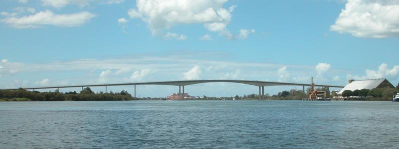
height=78.75 m (847 ft) AHD The Gateway Bridge is a road bridge at the centre of theGateway Motorway (M1), which skirts the eastern suburbs ofBrisbane ,Queensland ,Australia . It is the most eastern crossing of theBrisbane River , closest toMoreton Bay , crossing at the Quarries Reach, betweenEagle Farm and Murarrie.History
Construction on the Gateway Bridge commenced on
5 June 1980 . It was officially commissioned on11 January 1986 . Uniquely, the construction of the bridge started before the design was completed, to fast track its construction.In 2005, a major upgrade of the Gateway Motorway was announced. The $1.88 billion
Gateway Upgrade Project , includes the duplication of the Gateway Bridge and upgrades to convert|20|km|mi|0|abbr=on of the Gateway Motorway from Mt Gravatt-Capalaba Road in the south to Nudgee Road in the north.The upgrades to the Gateway Motorway include convert|12|km|mi|0|abbr=on of widening to at least six lanes, south of the Brisbane River, and the construction of a new convert|7|km|mi|0|abbr=on
Gateway Motorway deviation , north of the Brisbane River. The new motorway deviation is an entirely new six-lane motorway that will travel from the Gateway Bridges to just south of Nudgee Road throughBrisbane Airport Corporation land, east of the existing motorway and provide a second access to theBrisbane Airport .The Gateway Upgrade Project is being progressively delivered with each section of the project being opened to traffic as soon as it is completed. Motorists are already experiencing the benefits of the project with the first section, the
Wynnum Road Upgrade , being delivered on time and on budget and opened to traffic on July 13, 2007. By the end of 2007 there will be two additional southbound lanes between thePort of Brisbane Motorway andWynnum Road . By mid-2009 four of six lanes of the new Gateway Motorway deviation will be opened and by the end of 2009 all works south of the river will be completed. The duplicate Gateway Bridge will be opened in mid-2010 along with the remaining lanes of the Gateway Motorway deviation. Finally, the existing bridge will be refurbished with the entire project scheduled for completion in mid-2011.Design
On completion of construction, the main span of the Gateway Bridge was the world record (convert|260|m|ft|0|abbr=on|disp=/) for a
prestressed concrete free cantilever bridge. It held this record for over 15 years. The box girder is still the largest prestressed concrete, single box in the world, measuring convert|15|m|ft|0|abbr=on deep at the pier, with a box width of convert|12|m|ft|0|abbr=on and an overall deck width of the 6 lanes of convert|22|m|ft|0|abbr=on.The bridge owes its distinctive shape to air traffic requirements restricting its height to under 80 metres (263 ft) above sea level (all features of the bridge including light poles) coupled with shipping needs requiring a navigational clearance of 55 metres (180 ft).
The bridge has six lanes (three in each direction). The bridge was financed by funds borrowed by the
Queensland Government , and as a result, users of the bridge pay a toll on the southern side of the Brisbane River. The Bridge is operated and maintained byQueensland Motorways , which is a Queensland Government-owned enterprise.*Opened:
11 January 1986
*Total length: 1,627 metres (5,337 ft) in length. This is divided into a southern approach of 376 metres (1,234 ft), a northern approach of 731 metres (2,398 ft) and the three central spans of 520 metres (1,706 ft).
*Main span: 260 metres (853 ft) long X 64.5 metres (212 ft) high (equivalent to a 20-storey building)
*150,000 tonnes (165,346 t) of concrete
*Operated by: Queensland Motorwaysee also
*Metroad
*List of Australian freeways References
External links
* [http://www.gatewayupgradeproject.com.au Gateway Upgrade Project Website]
* [http://www.qldmotorways.com.au Queensland Motorways Website]
*Structurae|id=s0002214|title=Gateway Bridge
* [http://www.mainroads.qld.gov.au/MRWEB/PROD/WebCams.nsf/Show+Cams?OpenForm&cam=Gateway+Bridge+Toll Webcam of Gateway Bridge]
* [http://sketchup.google.com/3dwarehouse/download?mid=977cb2e0549d1a924808ad5e4163344f&rtyp=k&fn=gateway Google Earth (Version 4) 3D Model]
Wikimedia Foundation. 2010.