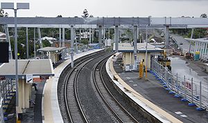
Darra railway station

Darra railway station
Darra
Darra train station 2009 1a.jpg
Station statistics
Address Darra Station Road, Darra
Coordinates 27°33′57″S 152°57′09″E / 27.5659°S 152.9524°E / -27.5659; 152.9524Coordinates: 27°33′57″S 152°57′09″E / 27.5659°S 152.9524°E / -27.5659; 152.9524
Lines
  Ipswich Line
  Springfield Line
Platforms 4 total (1 island, 2 sides)
Other information
Accessible Handicapped/disabled access
Code DAR[1]
Owned by Queensland Rail
Fare zone 3/4 (TransLink)
Services
Preceding station   Queensland Rail   Following station
toward Bowen Hills
Ipswich Line
Wacol
toward Rosewood
toward Bowen Hills
Springfield Line
Richlands
Terminus

Darra is a railway station in the suburb of Darra on the Ipswich and Springfield lines.

Construction of the Springfield line

The station is the junction where the Springfield Line outlined under the South East Queensland Infrastructure Plan and Program joins the Ipswich line. The station was recently expanded with two additional platforms to enable services for the Springfield Line which commenced to Richlands in January 2011. During construction a hand grenade was found by workers and then safely disposed of by army personnel.[2]

References

External links


Wikimedia Foundation. 2010.

Игры ⚽ Поможем сделать НИР

Look at other dictionaries:

  • Darra railway station, Brisbane — Citytrain Station station name=Darra region=Brisbane West servicearea1=Ipswich IB1=Oxley OB1=Wacol street=Railway Parade and Manburgh Terrace suburb=Darra zone=3/4 distance=16.02 platforms=3 (Originally 4; Platform 1 revamped for disability ramp) …   Wikipedia

  • Oxley railway station — Oxley Station statistics Address Ardoyne Road, Oxley Coordinates …   Wikipedia

  • Chelmer railway station — Chelmer Station statistics Address 140 Honour Avenue, Chelmer Coordinates …   Wikipedia

  • Corinda railway station — Corinda Station statistics Address Cnr Watt Street Ruthven Street, Corinda Coordinates …   Wikipedia

  • Dinmore railway station — Dinmore Station statistics Address River Road and Mason Street, Dinmore Coordinates …   Wikipedia

  • Darra, Queensland — Darra Brisbane, Queensland Shops in Darra. Population: 3,813 …   Wikipedia

  • Milton railway station, Brisbane — Milton Station statistics Address Milton Road, Milton Coordinates …   Wikipedia

  • Richlands railway station, Brisbane — Citytrain Station station name=Richlands region=Springfield servicearea1=Springfield IB1=Darra OB1=terminus street=Progress Road suburb=Richlands zone=4 distance=unknown platforms=2 platform arch=1 island access= trainconnect= busconnect= tvm=… …   Wikipedia

  • South Brisbane railway station, Brisbane — Citytrain Station station name=South Brisbane region=Brisbane Central servicearea1=Gold Coast servicearea2=Cleveland servicearea3=Beenleigh servicearea4=Shorncliffe servicearea5=Corinda via South Brisbane comment4= weekends only IB1=Roma Street… …   Wikipedia

  • Park Road railway station, Brisbane — Citytrain Station station name=Park Road region=Brisbane South servicearea1=Cleveland servicearea2=Beenleigh servicearea3=Corinda via South Brisbane IB1=South Bank OB1=Buranda IB2=South Bank OB2=Dutton Park IB3=South Bank OB3=Dutton Park… …   Wikipedia

Share the article and excerpts

Direct link
Do a right-click on the link above
and select “Copy Link”