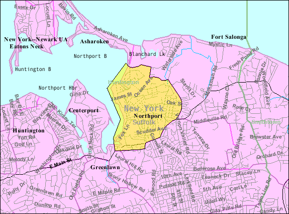
- Northport, New York
-
Northport — Village — Main Street
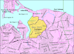

 Northport
Coordinates: 40°54′10″N 73°20′39″W / 40.90278°N 73.34417°WCoordinates: 40°54′10″N 73°20′39″W / 40.90278°N 73.34417°W Country  United States
State  New York
County Suffolk Township Huntington Settled 1656 Incorporated 1894 Government – Type Incorporated Village – Elected Officials Mayor: George Doll;
Deputy Mayor: Henry Tobin;
Trustees: Tom Kehoe, Jerry Maline, Damon McMullen;
Justice: Paul SenzerArea – Total 2.5 sq mi (6.6 km2) – Land 2.3 sq mi (6.0 km2) – Water 0.2 sq mi (0.6 km2) Elevation 0-59 ft (0-18 m) Population (2000) – Total 7,606 – Density 3,292.7/sq mi (1,271.3/km2) Time zone EST (UTC-5) – Summer (DST) EDT (UTC-4) ZIP code 11768 Area code(s) 631 FIPS code 36-53396 GNIS feature ID 0958968 Website Official Northport Website Northport is a village in Suffolk County, New York on the North Shore of Long Island. As of the United States 2000 Census, the village population was 7,606. Students attend the Northport-East Northport Union Free School District.
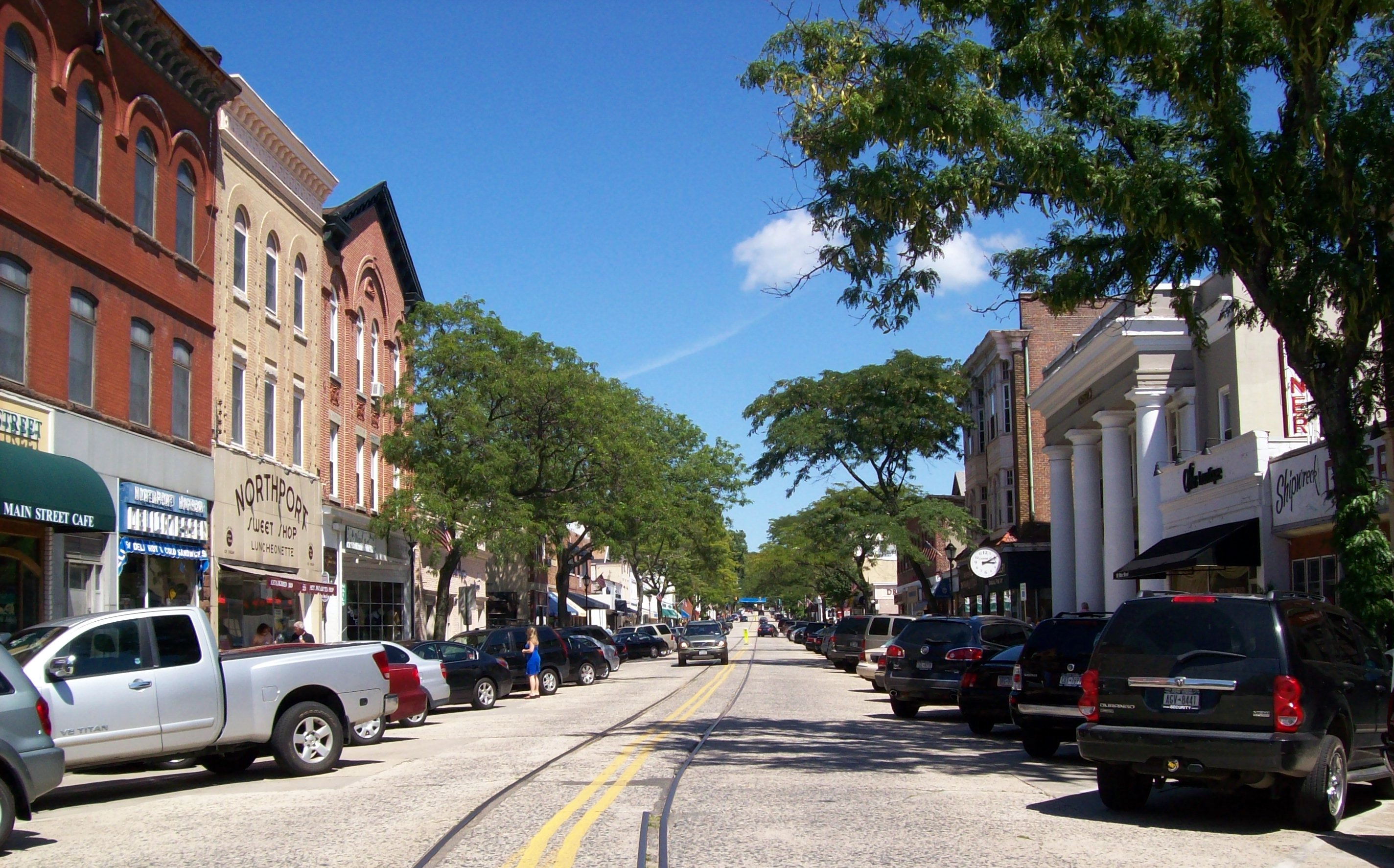
The village of Northport sits along New York State Route 25A in the Town of Huntington, on Long Island's picturesque North Shore. It is known for its bucolic main street which still bears trolley rails from a long discontinued streetcar that brought people to the village from the Long Island Rail Road station in East Northport. Main Street ends at the village dock and village green, site of numerous "concerts in the park" on summer evenings. It has a number of fine restaurants and ice cream parlors, antique stores, as well as an old-style barbershop, and other independent retailers. Northport's old world charm and sense of community make it a very desirable residential location in Western Suffolk County with around an hour commute to New York City.
Contents
History
European settlement
The original inhabitants of the area now known as Northport were the Matinecocks, one of 13 Native American tribes of Long Island. The Matinecocks called this land "Opcathontyche", which meant "wading place creek".[1] After Dutch interest a few years earlier, the land was sold by Chief Asharoken, head of the Matinecocks, to three Englishmen in 1656.[2]
With land that was well suited for farming, the early settlers grazed cattle on pastures around the harbor. The area soon became known as Great Cow Harbor.[3] (The nearby hamlet of Centerport was known as Little Cow Harbor.) The oldest house still standing in Northport, the Skidmore House on Main Street, was built in 1761. In 2009 the house was put up for sale, sparking the village to pass a historical preservation law.[4]
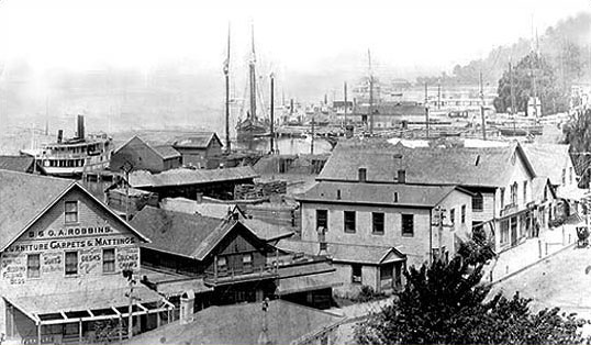
Growth, change, and shipbuilding
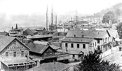 Woodbine Avenue and Northport Harbor, circa 1900
In the early 19th century Great Cow Harbor was still a rural farming community. By the 1830s the village contained only eight dwellings.[5] But a new industry of shipbuilding brought rapid change and growth. The village shifted away from its farming roots as shipbuilding became the community's primary industry. By 1837 the village was being referred to as Northport.[1]
The 1860 census listed Northport's population at 1,016. By 1874 it had become the most flourishing village in all of Suffolk County's north shore, with three ship yards, five sets of marine railways, two hotels, and at least six general stores.[5]
Northport's shipbuilding boom lasted fifty years but waned at the end of the century as steel-hulled ships began replacing the wooden vessels produced in the village.[1]
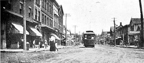
Railroads and trolleys
 Main Street, sometime between 1902 and 1909
On April 25, 1868 the Long Island Railroad opened a station within the village of Northport.[6] This was an essential transportation link for the village, especially for the growing commuter population. However, just a few years later the LIRR decided to move the Northport station to a new location in Larkfield to facilitate further railway extension to Port Jefferson. The new railway station located on Larkfield Road was opened on January 13, 1873[7] and retained the station name of Northport.
To avoid confusion with the former station located in the village of Northport, train conductors would refer to the station in Larkfield as "East of Northport" because the station was located east of the Northport railway junction which directed trains north to the station located in the village. Despite the fact that Larkfield was primarily south of Northport, the area became known thereafter as East Northport.[8] The original rail spur to Northport would then be known as the Northport Branch. After the old bypassed village station closed in 1899, Northport decided to build a 2½ mile trolley line to take commuters between Main Street and the new Northport station located in Larkfield. The new commuter trolley opened in mid-April 1902. The trolley would eventually become obsolete with the invention of the automobile and the trolley made its last scheduled commuter run on August 19, 1924.[9]
Incorporation and annexation
Although it was known by the name of Northport since at least 1837, the village of Northport was formally incorporated in 1894,[3] the first village to do so in Huntington Township.[1] Over the years Northport has expanded from its original borders, annexing other established communities.
Around the Revolutionary War, a concentration of 31 families began settling 1½ miles east of Northport, around where Main Street and Route 25A now intersect 40°53′58″N 73°19′47″W / 40.8995°N 73.3296°W. This settlement was originally known as Red Hook[1] and changed names to Vernon Valley in 1820.[3] By 1874 Vernon Valley had a population of around 150 inhabitants.[5] Vernon Valley became part of Northport in the mid-20th century.[5][10]
Northport also annexed the formerly independent settlement of Crab Meadow 40°55′15″N 73°19′13″W / 40.9207°N 73.3202°W[11] (also known as Great Neck[12]), as well as westerm parts of the Freshpond community 40°55′21″N 73°17′47″W / 40.9224°N 73.2965°W.
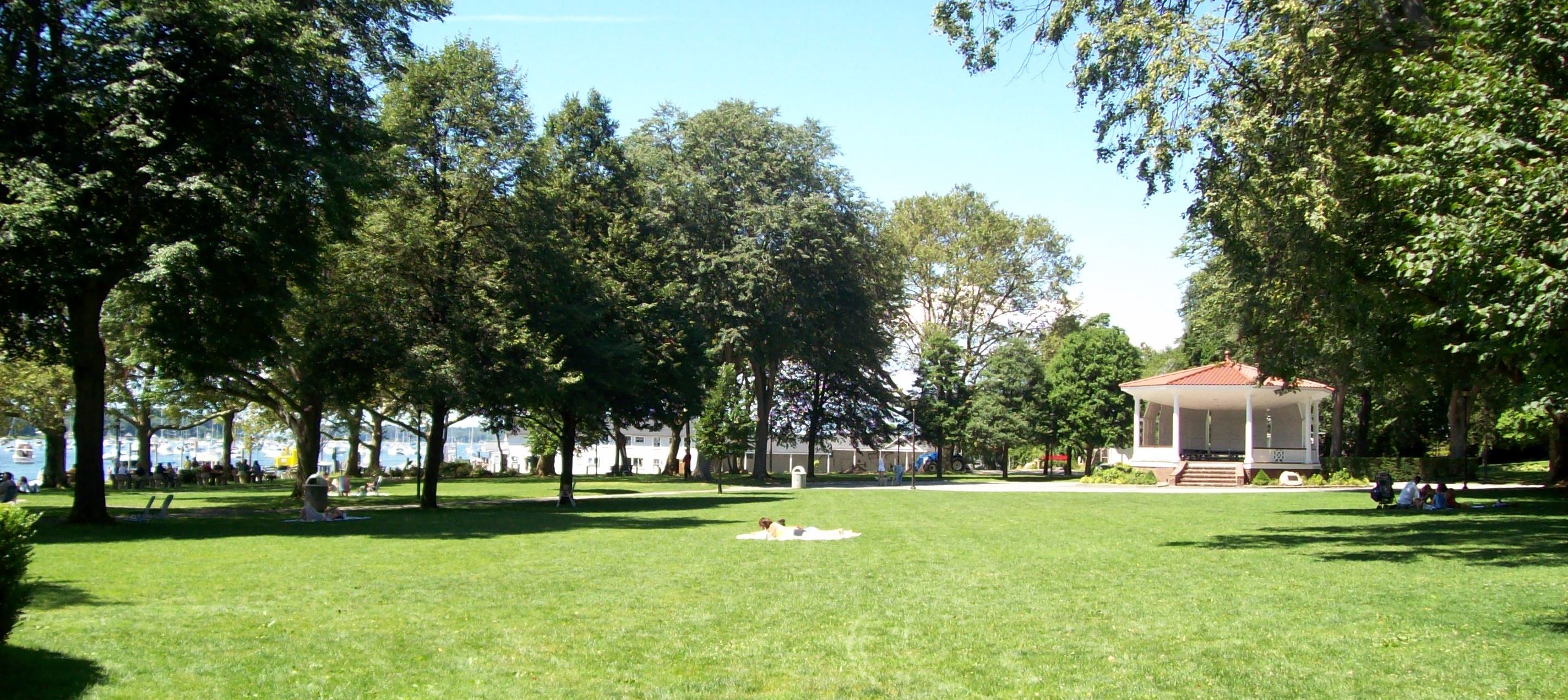
Modern Northport
 Northport Memorial Park at the edge of Northport Harbor
After nearly a century of heavy commercial use, the waterfront which had supported the community for generations, had fallen into decay by the 1920s. The village decided to purchase the land along the harbor and created Northport Memorial Park in 1932, which is a defining feature of Northport today.[1]
In 1967, the Long Island Lighting Company (LILCO) opened the Northport Power Station, which is currently the largest oil-fired electric generating station on the East coast.[13] The four enormous stacks are a well known landmark that can be seen as far away as Connecticut across Long Island Sound. Each stack is 600 feet tall.[14]
The Northport Trolley which had ceased operations in 1924 enjoyed a popular revival in the 1970s and 1980s, transporting weekend tourists along Main Street. Unlike the original electric trolleys, this nostalgic replica was horse driven. It also ran on rubber automobile tires rather than utilizing the original rails which still remain a visible element of Main Street to this day.
In 1984 Northport garnered nationwide media attention as the site of a gruesome satanic murder by high school dropout Ricky Kasso.[15] Long after the crime, the unfortunate events have been recounted in books[16] and movies,[17] from which the village of Northport has suffered a negative reputation for satanism.[17]
In 2005, a coalition of New York environmental groups issued a report which named the Northport Power Station as the number one polluting power plant on Long Island and the second most polluting plant in the Northeast.[18]
Every September the village of Northport commemorates its rich history with the celebration of Cow Harbor Day, which follows the annual Great Cow Harbor 10K race.
Geography
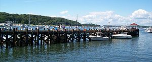 Northport Village Dock in Northport Harbor
Northport is located at 40°54′10″N 73°20′39″W / 40.90278°N 73.34417°W (40.902803, -73.344069).[19] According to the United States Census Bureau, the village has a total area of 2.5 square miles (6.5 km2), of which, 2.3 square miles (6.0 km2) of it is land and 0.2 square miles (0.52 km2) of it (9.02%) is water.
Most of the village is made up of the low, steep hills of Long Island's northern terminal moraine. To the west is the highly sheltered Northport Harbor, to the north is Long Island Sound, and to the east are woods and marshland.
A prominent feature of Northport is Steer’s Pit (known simply as "The Pit" to locals[1]), a large land depression carved into the cliffs adjacent to Northport Harbor and just south of the enormous LIPA smokestacks. This unusual geographic feature is the result of sand mining operations by the Steers and Steers Company. Mining began in 1923 and ceased in the 1950s.[20] The mined sand was shipped by barge to New York City where, mixed with Portland cement and rock aggregate, it became the sidewalks of New York.[citation needed] The area has since been utilized for home and condo use and a portion of the Pit is a park used by local youth soccer and baseball leagues. The Northport Fire Department also maintains a training facility in the Pit that is the site of the annual firemen fair in the summer.
Demographics
As of the census[21] of 2010, there were 7,753 people, 2,955 households, and 2,074 families residing in the village. The population density was 3,290.0 people per square mile (1,276.3/km²). There were 3,052 housing units at an average density of 1,320.0 per square mile (510.1/km²). The racial makeup of the village was 92.04% White, 2.59% African American, 0.05% Native American, 1.25% Asian, 0.01% Pacific Islander, 0.30% from other races, and 0.75% from two or more races. Hispanic or Latino of any race were 5.09% of the population.
There were 2,955 households out of which 33.2% had children under the age of 18 living with them, 59.8% were married couples living together, 8.5% had a female householder with no husband present, and 29.9% were non-families. 25.9% of all households were made up of individuals and 8.0% had someone living alone who was 65 years of age or older. The average household size was 2.55 and the average family size was 3.07.
In the village the population was spread out with 23.8% under the age of 18, 5.8% from 18 to 24, 30.1% from 25 to 44, 28.8% from 45 to 64, and 12.1% who were 65 years of age or older. The median age was 40 years. For every 100 females there were 94.6 males. For every 100 females age 18 and over, there were 91.6 males.
The median income for a household in the village was $90,250, and the median income for a family was $104,488. Males had a median income of $78,715 versus $50,119 for females. The per capita income for the village was $43,694. About 1.6% of families and 2.8% of the population were below the poverty line, including 3.7% of those under age 18 and 2.8% of those age 65 or over.
Notable residents
Performing arts
- Robert Burke - Actor- Law & Order
- Peter Calandra - Broadway, movie, and television pianist/composer.[22][23]
- Edie Falco - Broadway, movie, and television actress best known for her role as Carmela Soprano on the The Sopranos.
- Alison Fanelli - Actress who is best known for the role on the television series The Adventures of Pete & Pete[24]
- Elizabeth Hendrickson - Television actress best known for her role as twin sisters Frankie and Maggie Stone on All My Children.[25]
- Patti Lupone - Tony Award-winning broadway and television actress, best known for her role as Eva Peron in Evita.[26]
- Chris Messina - Television actor, best known for his role as Ted Fairwell on Six Feet Under[27][28][29]
- Dan Milano - Television writer and voice actor best known as the co-creator of the show Greg the Bunny.[30][31]
- Gretchen Rau - Academy Award-winning motion picture set decorator.
- John Scurti - Television actor best known for his role as Kenny Shea on Rescue Me[32]
- Craig Ricci Shaynak - Television character actor[33]
Musicians
- Wendy Andreiev (Wendy Wild) - Lead vocalist in the 1980s for several New York–based bands.
- Ian Matthias Bavitz (Aesop Rock) - Hip-Hop, Rap artist.
- Vance Brescia - Singer-songwriter. Lead vocals and guitar for the 1980s rock and roll band The Mosquitos, Musical Director and lead guitarist for Herman's Hermits Starring Peter Noone.
- Brendan B. Brown - Lead vocalist for the band Wheatus.
- Frank Funaro - Drummer for Cracker
Writers
- Edwin G. Burrows - Won 1999 Pulitzer Prize for History for the book Gotham: A History of New York City to 1898.[34]
- Greg Fox - Nationally syndicated comic strip artist/writer (His comic Kyle's Bed & Breakfast takes place in Northport.)
- Jack Kerouac - Novelist and writer commonly credited as the catalyst for the 1960s counterculture movement.[35]
Sports
- Greg Buttle - Former NFL football player for the New York Jets.
- Darius Kasparaitis - Former NHL ice hockey player for the New York Islanders, Pittsburgh Penguins, Colorado Avalanche and the New York Rangers.[36]
- Andy Lally - GRAND-AM and NASCAR race car driver, and street luge racer.
- Phil Weber Jr. - Former North Carolina State basketball player and current assistant coach for the Knicks.[37][38]
Others
- Andrew Geller - Renowned architect.[39][40][41]
- Ricky Kasso - Murderer
- Bruce Morrison - Former United States Congressman from Connecticut. He grew up in Northport and attended Northport High School.[42]
- Alia Sabur - Youngest professor in history.[43]
See also
- Northport-East Northport Union Free School District
- Northport High School
- Cow Harbor Day
- Great Cow Harbor 10K
- Northport Power Station
- Eatons Neck, New York
- Asharoken, New York
- East Northport, New York
References
- ^ a b c d e f g Bleyer, Bill. "Northport: A Harbor of Transformations". Long Island, Our History. Newsday. http://www.newsday.com/community/guide/lihistory/ny-historytown-hist005c,0,6458687.story?coll=ny-lihistory-navigation. Retrieved 2007-02-08.
- ^ "About Northport". Northport Chamber of Commerce. http://www.northportny.com/about.php. Retrieved 2007-02-08.
- ^ a b c Little, Bob. "The Many Names of Northport". Northport History. Northport Historical Society. http://www.theliconnection.com/editorials/760. Retrieved 2007-02-08.
- ^ Fischler, Marchelle (10 March 2010). "On Long Island, Protecting These Old Houses". New York Times (New York Times Company). http://www.nytimes.com/2010/03/14/realestate/14Lizo.html?emc=eta1. Retrieved 13 March 2010.
- ^ a b c d Bayles, Richard Mather (1874). Historical and Descriptive Sketches of Suffolk County and Its Towns, Villages, Hamlets, Scenery, Institutions, and Important Enterprises: With a Historical Outline of Long Island, from Its First Settlement by Europeans. The Author. pp. 162–164. http://books.google.com/?id=QGPEBAjYLn0C&pg=PA162.
- ^ "PRR Chronology, 1868" (PDF). The Pennsylvania Railroad Technical & Historical Society. June 2004. http://www.prrths.com/Hagley/PRR1868%20June%2004.wd.pdf. Retrieved 2007-02-08.
- ^ "PRR Chronology, 1873" (PDF). The Pennsylvania Railroad Technical & Historical Society. February 2005. http://www.prrths.com/Hagley/PRR1873%20Feb%2004.pdf. Retrieved 2007-02-08.
- ^ "East Northport: East Was Added When The Trains Came". Long Island, Our History. Newsday. http://www.newsday.com/community/guide/lihistory/ny-historytown-hist0056,0,3509522.story. Retrieved 2007-02-12.
- ^ "East Northport Town History". East Northport Chamber of Commerce. Archived from the original on 2007-02-05. http://web.archive.org/web/20070205075857/http://www.eastnorthport.com/townhistory.htm. Retrieved 2007-02-08.
- ^ Legislature, New York (State) (1928). New York Legislative Document. J.B. Lyon Co.. pp. 179. http://books.google.com/?id=LPVKAAAAMAAJ&q=%22Vernon+Valley%27+Northport&dq=%22Vernon+Valley%27+Northport.
- ^ French, John Homer; Frank Place (1860). Gazetteer of the State of New York. R.P. Smith. ISBN 0806314567. http://books.google.com/?id=0kkVAAAAYAAJ&pg=PA635.
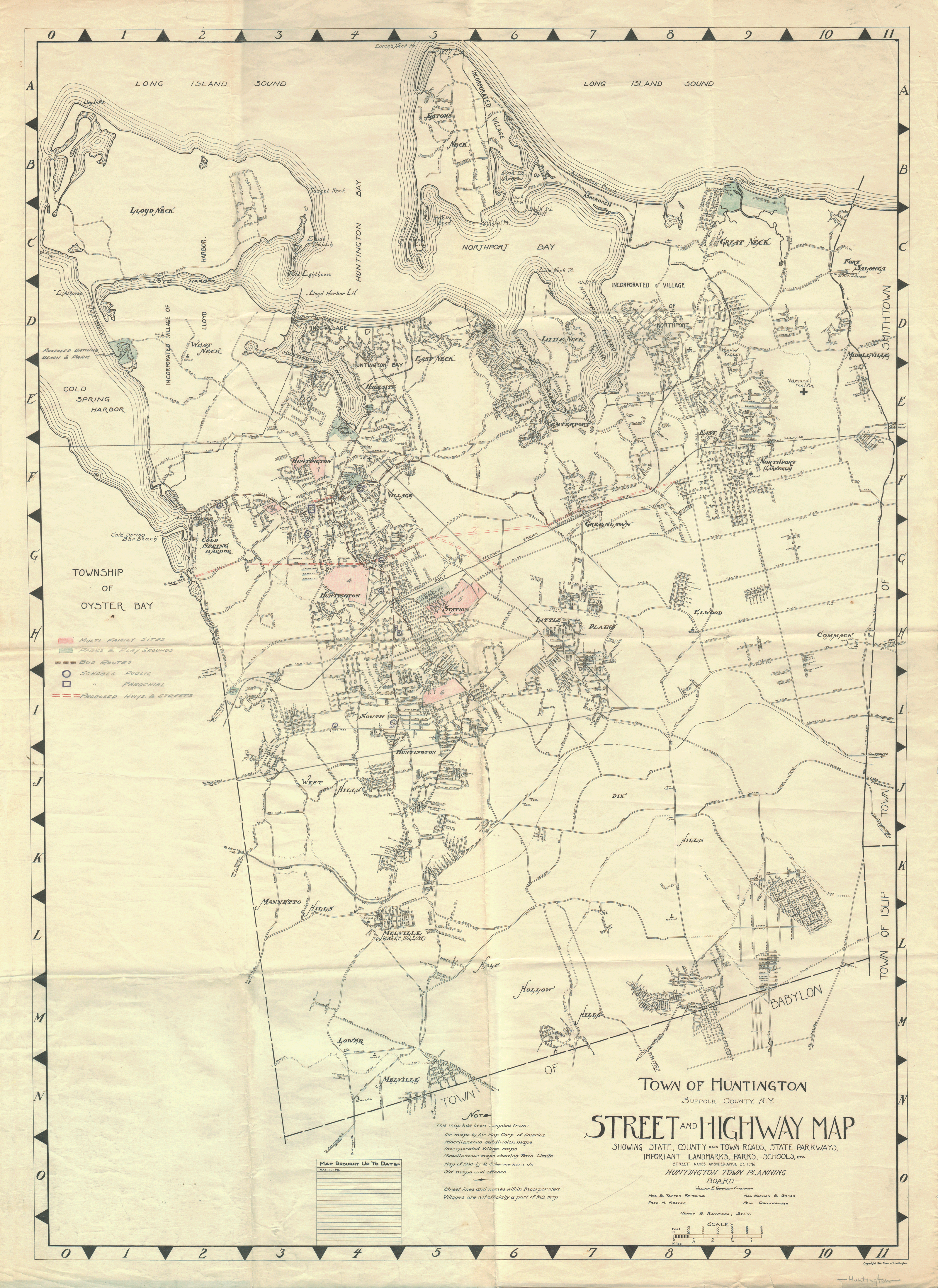
- ^ Town of Huntington (1946). Town of Huntington Suffolk County, N.Y. Street and Highway Map (Map). http://upload.wikimedia.org/wikipedia/commons/f/fa/1946_Huntington_Planning_Map.png.
- ^ "Schumer Calls For Modernization Of Northport, Port Jefferson Power Plants; Long Island Among Worst In Nation For Smog And Ozone Levels" (Press release). United States Congress (via Charles E. Schumer). 2005-08-09. http://www.senate.gov/~schumer/SchumerWebsite/pressroom/record.cfm?id=260503. Retrieved 2007-12-04.
- ^ "Gas- and Oil-Fired Plants in New York". Power Plants Around The World. May 24, 2006. http://www.industcards.com/st-other-usa-ny.htm. Retrieved 2007-12-04.
- ^ Manning, Gregg. "The Ultimate Crime". http://www.real-crime.co.uk/Murder1/dock.html#Kasso. Retrieved 2007-11-01.
- ^ St. Clair, David (October 1, 1987). Say You Love Satan. Dell. ISBN 0440175747. http://www.amazon.com/Say-Love-Satan-David-Clair/dp/0440175747.
- ^ a b "Satan in the Suburbs". The New York Times. http://movies.nytimes.com/movie/307491/Satan-in-the-Suburbs/overview. Retrieved 2007-11-01.
- ^ "Northport's Dirty Burden". The New York Times. 2005-08-21. http://www.nytimes.com/2005/08/21/opinion/nyregionopinions/LI_Energy.html?_r=1&oref=slogin. Retrieved 2007-12-04.
- ^ "US Gazetteer files: 2010, 2000, and 1990". United States Census Bureau. 2011-02-12. http://www.census.gov/geo/www/gazetteer/gazette.html. Retrieved 2011-04-23.
- ^ Bennington, J Bret (2002-11-03). "Glacial Features of the Huntington and Northport Area, Long Island". Department of Geology. Hofstra University. http://people.hofstra.edu/faculty/J_B_Bennington/field_trips/caumsett_02/northport_trip.htm. Retrieved 2007-02-08.
- ^ "American FactFinder". United States Census Bureau. http://factfinder.census.gov. Retrieved 2008-01-31.
- ^ "Peter Calandra / Composer". http://www.pecamusic.com/bio/bio.htm. Retrieved 2007-11-11.
- ^ "Peter Calandra". IMDb. http://www.imdb.com/name/nm0129321/. Retrieved 2007-11-11.
- ^ "Alison Fanelli". IMDb. http://www.imdb.com/name/nm0266725/. Retrieved 2010-01-21.
- ^ "Elizabeth Hendrickson". IMDb. http://www.imdb.com/name/nm1058513/. Retrieved 2010-01-21.
- ^ "Patti Lupone". IMDb. http://www.imdb.com/name/nm0526985/. Retrieved 2010-01-21.
- ^ "Rozie Bacchi Publicity Stills & Production Photos". Rozie Bacchi. http://roziebacchi.tripod.com/rozie_photos_prod.html. Retrieved 2007-11-12.
- ^ "Biography for Joe Roseto". IMDb. http://www.imdb.com/name/nm0742886/bio. Retrieved 2007-11-12.
- ^ "Chris Messina". IMDb. http://www.imdb.com/name/nm0582149/. Retrieved 2007-11-12.
- ^ "Dan Milano". IMDb. http://www.imdb.com/name/nm0586850/. Retrieved 2010-01-21.
- ^ Open Seas 1990 (Northport High School Yearbook). 11. Marceline, Missouri: Walsworth Publishing Company. 1990. p. 169
- ^ "John Scurti". IMDb. http://www.imdb.com/name/nm0780336/. Retrieved 2010-01-21.
- ^ "Craig Ricci Shaynak". IMDb. http://www.imdb.com/name/nm1575801/. Retrieved 2010-01-21.
- ^ DeWan, George (April 24, 2000). "LONG ISLAND OUR PAST / LI to NY: Hey, You Owe Us". Newsday. http://www.newsday.com/news/long-island-our-past-li-to-ny-hey-you-owe-us-a-prize-winning-historian-points-out-where-the-city-would-be-without-the-suburb-1.299073. Retrieved 2009-10-22.
- ^ Asher, Levi (September 19, 2001). "Jack Kerouac". Literary Kicks. http://www.litkicks.com/BeatPages/page.jsp?what=JackKerouac. Retrieved 2007-11-02.
- ^ Diamos, Jason (1996-11-18). "Islanders Trade Kasparaitis for Smolinski". New York Times. http://query.nytimes.com/gst/fullpage.html?res=9406E3DD133AF93BA25752C1A960958260. Retrieved 2008-05-31.
- ^ "Phil Weber Jr. Back in New York". The Observer. 2008-07-05
- ^ "Knicks fill out Mike D'Antoni's coaching staff". Associated Press. June 20, 2008. http://ap.google.com/article/ALeqM5gdCotFryLY4TTMkH6SiOgsAOyEfwD91DVVI81. Retrieved 2008-07-06.
- ^ "LEISUREAMA HOMES". History Detectives. 2005. No. 10, season 3.
- ^ "Episode 10, 2005: Leisurama (transcript)" (PDF). History Detectives. PBS. http://www.pbs.org/opb/historydetectives/pdf/310_leisureama.pdf. Retrieved 2009-09-22.
- ^ Gorst, Jake. "Andrew M Geller Biography". http://www.andrewgeller.net/. Retrieved 2009-09-22.
- ^ "MORRISON, Bruce Andrew, (1944 - )". Biography Directory of the U.S. Congress. http://bioguide.congress.gov/scripts/biodisplay.pl?index=M000992. Retrieved 2008-07-27.
- ^ "Guinness names Northport teen world's youngest professor". Newsday. http://www.newsday.com/news/local/ny-liwhiz0422,0,4702323.story. Retrieved 2008-04-22.
- Ruther, Frederick (1909). Long Island To-Day. New York: The Essex Press.
External links
- Official website of the Incorporated Village of Northport, NY
- Northport Chamber of Commerce
- Northport Historical Society
- Quicktime Panorama of Steers Pit
County Villages Asharoken · Huntington Bay · Lloyd Harbor · Northport
Hamlets Centerport · Cold Spring Harbor · Commack · Dix Hills · East Northport · Eatons Neck · Elwood · Fort Salonga · Greenlawn · Halesite · Huntington Station · Huntington · Melville · South Huntington · Vernon Valley · West Hills · Wincoma
Website: town.huntington.ny.usCategories:- Huntington, New York
- Villages in New York
- Populated places in Suffolk County, New York


Wikimedia Foundation. 2010.