- East Northport, New York
Infobox Settlement
official_name = East Northport, New York
settlement_type = CDP
nickname =
motto =
imagesize =
image_caption =
image_pushpin_
pushpin_label_position =none
pushpin_map_caption =Location within the state of New York
pushpin_mapsize =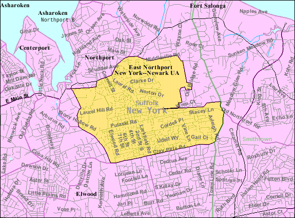
mapsize = 250px
map_caption = U.S. Census Map
mapsize1 =
map_caption1 =subdivision_type = Country
subdivision_name =United States
subdivision_type1 = State
subdivision_name1 =New York
subdivision_type2 = County
subdivision_name2 = Suffolk
government_footnotes =
government_type =
leader_title =
leader_name =
leader_title1 =
leader_name1 =
established_title =
established_date =area_footnotes =
area_magnitude =
area_total_km2 = 15.2
area_land_km2 = 15.2
area_water_km2 = 0.0
area_total_sq_mi = 5.9
area_land_sq_mi = 5.9
area_water_sq_mi = 0.0population_as_of = 2000
population_footnotes =
population_total = 20845
population_density_km2 = 1373.2
population_density_sq_mi = 3556.5timezone = Eastern (EST)
utc_offset = -5
timezone_DST = EDT
utc_offset_DST = -4
elevation_footnotes =
elevation_m = 68
elevation_ft = 223
latd = 40 |latm = 52 |lats = 45 |latNS = N
longd = 73 |longm = 19 |longs = 27 |longEW = Wpostal_code_type =
ZIP code
postal_code = 11731
area_code = 631
blank_name = FIPS code
blank_info = 36-22612
blank1_name = GNIS feature ID
blank1_info = 0949189
website =
footnotes =East Northport is a hamlet and
census-designated place (CDP) in the Town of Huntington in Suffolk County,New York ,United States . The population was 20,845 at the 2000 census.History
Founding
Soon after the establishment of a village in the Huntington area, English
settlers sought to further expand their territory. OnJuly 30 ,1656 , land was purchased from Chief Asharoken, head of the Matinecocks Native American tribe, part of which consisted of the land that is today known as East Northport.cite web | title = East Northport Town History | publisher = East Northport Chamber of Commerce | url = http://www.eastnorthport.com/townhistory.htm | accessdate = 2007-02-12 ]Larkfield & Clay Pitts
Two distinct communities formed in the area now known as East Northport. The more populous settlement known as Larkfield was located on the northern side, near Vernon Valley (now part of Northport). Larkfield originally developed near the location of Genola Cemetery, just north of the modern-day junction of Larkfield Road, Vernon Valley Road, and Laurel Road. A second community located on the southern side was known as Clay Pitts, named for its vast deposits of red clay. This clay which had been used by Native Americans to form pottery was used by the Europeans to form bricks for construction.cite web | title = East Northport: East Was Added When The Trains Came | work = Long Island, Our History | publisher = Newsday | url = http://www.newsday.com/community/guide/lihistory/ny-historytown-hist0056,0,3509522.story | accessdate = 2007-02-12 ] The land between Larkfield and Clay Pitts was well suited for agriculture and the region prospered in the late 18th century as a thriving farming community by supplying produce to markets in
New York City andBrooklyn .East Northport
In 1868 the
Long Island Railroad opened a station within the village of Northport.cite web | title = PRR Chronology, 1868 | publisher = The Pennsylvania Railroad Technical & Historical Society | month = June | year = 2004 | url = http://www.prrths.com/Hagley/PRR1868%20June%2004.wd.pdf | format = PDF | accessdate = 2007-02-12 ] However, just a few years later the LIRR decided to move the Northport station to a new location in Larkfield to facilitate further railway extension to Port Jefferson. The new railway station located at Larkfield Road and Bellerose Avenue opened onJanuary 13 ,1873 .cite web | title = PRR Chronology, 1873 | publisher = The Pennsylvania Railroad Technical & Historical Society | month = February | year = 2005 | url = http://www.prrths.com/Hagley/PRR1873%20Feb%2004.pdf | format = PDF | accessdate = 2007-02-12 ] Although the station retained the name of Northport, train conductors would refer to it as "East of Northport" because the station was located east of therailway junction which used to direct trains north to the old station located in the village of Northport. Despite the fact that East Northport is primarily "south" of Northport, the area became known thereafter as East Northport. The Larkfield Post Office formally changed its name to East Northport in 1910.uburban Growth
As American military personnel returned home from
World War II ,Long Island experienced a dramatic population shift from large cities to suburban areas. East Northport's population exploded as a housing boom transformed the rural farmland into modernsuburbs . Today East Northport is the largest community in Huntington Township, both by land area and population.Geography
East Northport is located at coor dms|40|52|45|N|73|19|27|W|city (40.879248, -73.324133).GR|1
According to the
United States Census Bureau , the CDP has a total area of 5.9 square miles (15.2 km²), all land.Demographics
As of the
census GR|2 of 2000, there were 20,845 people, 6,967 households, and 5,552 families residing in the CDP. Thepopulation density was 3,556.5 per square mile (1,373.4/km²). There were 7,086 housing units at an average density of 1,209.0/sq mi (466.9/km²). The racial makeup of the CDP was 94.72% White, 0.91% African American, 0.12% Native American, 2.28% Asian, 0.03% Pacific Islander, 0.70% from other races, and 1.24% from two or more races. Hispanic or Latino of any race were 3.91% of the population.There were 6,967 households out of which 38.1% had children under the age of 18 living with them, 66.3% were married couples living together, 10.0% had a female householder with no husband present, and 20.3% were non-families. 15.7% of all households were made up of individuals and 6.4% had someone living alone who was 65 years of age or older. The average household size was 2.90 and the average family size was 3.24.
In the CDP the population was spread out with 25.5% under the age of 18, 5.6% from 18 to 24, 31.6% from 25 to 44, 23.5% from 45 to 64, and 13.8% who were 65 years of age or older. The median age was 38 years. For every 100 females there were 97.5 males. For every 100 females age 18 and over, there were 94.4 males.
The median income for a household in the CDP was $73,341, and the median income for a family was $80,291. Males had a median income of $54,054 versus $38,419 for females. The
per capita income for the CDP was $28,666. About 2.9% of families and 4.1% of the population were below thepoverty line , including 4.4% of those under age 18 and 4.9% of those age 65 or over.Schools
Most students residing in East Northport attend the
Northport-East Northport Union Free School District , with some attending theCommack School District or theElwood School District . A small part of community can also attend Kings Park and Harborfields School Districts. The following schools are located within East Northport:Public schools
* East Northport Middle School
* Bellerose Elementary School
* Dickinson Avenue Elementary School
* Fifth Avenue Elementary School
* Pulaski Road SchoolPrivate/religious schools
*
St. Paul's Lutheran School (Lutheran K-5
* Trinity Regional School (Catholic K-8)
* Ceadar Road School (Gan Israel)Notable residents
*Steve Park,
NASCAR driver
*Ashley Massaro , ProfessionalWWE wrestler
*Anthony Burulcich , Drummer forThe Bravery External links
* [http://www.eastnorthport.com/ East Northport Chamber of Commerce]
References

Wikimedia Foundation. 2010.