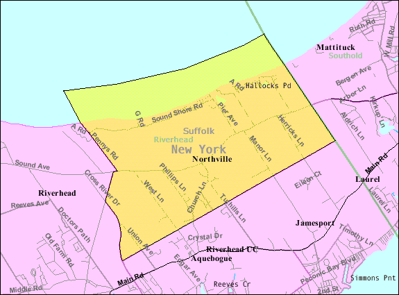
- Northville, Suffolk County, New York
-
Northville — Census-designated place — 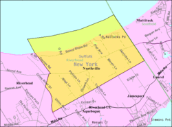 Location within the state of New York
 Northville
Coordinates: 40°58′3″N 72°37′27″W / 40.9675°N 72.62417°WCoordinates: 40°58′3″N 72°37′27″W / 40.9675°N 72.62417°W Country United States State New York County Suffolk Area - Total 9.7 sq mi (25.1 km2) - Land 7.4 sq mi (19.2 km2) - Water 2.2 sq mi (5.7 km2) Population (2000) - Total 801 - Density 82.6/sq mi (31.9/km2) Time zone Eastern (EST) (UTC-5) - Summer (DST) EDT (UTC-4) ZIP codes FIPS code GNIS feature ID Northville is a census-designated place (CDP) in Suffolk County, New York, United States. The population was 801 at the 2000 census.
Geography
Northville is located at 40°58′3″N 72°37′27″W / 40.9675°N 72.62417°W (40.967635, -72.624296)[1].
According to the United States Census Bureau, the CDP has a total area of 9.7 square miles (25 km2), of which, 7.4 square miles (19 km2) of it is land and 2.2 square miles (5.7 km2) of it (23.29%) is water.
Demographics
As of the census[2] of 2000, there were 801 people, 296 households, and 224 families residing in the CDP. The population density was 108.1 per square mile (41.7/km²). There were 401 housing units at an average density of 54.1/sq mi (20.9/km²). The racial makeup of the CDP was 93.26% White, 3.87% African American, 0.12% Native American, 0.25% Asian, 0.62% Pacific Islander, 0.12% from other races, and 1.75% from two or more races. Hispanic or Latino of any race were 4.87% of the population.
There were 296 households out of which 30.7% had children under the age of 18 living with them, 65.9% were married couples living together, 6.1% had a female householder with no husband present, and 24.0% were non-families. 18.6% of all households were made up of individuals and 7.1% had someone living alone who was 65 years of age or older. The average household size was 2.59 and the average family size was 2.96.
In the CDP the population was spread out with 22.3% under the age of 18, 4.7% from 18 to 24, 30.2% from 25 to 44, 27.6% from 45 to 64, and 15.1% who were 65 years of age or older. The median age was 41 years. For every 100 females there were 108.6 males. For every 100 females age 18 and over, there were 108.7 males.
The median income for a household in the CDP was $57,188, and the median income for a family was $68,571. Males had a median income of $42,500 versus $40,294 for females. The per capita income for the CDP was $28,547. None of the families and 2.6% of the population were living below the poverty line, including no under eighteens and none of those over 64.
References
- ^ "US Gazetteer files: 2010, 2000, and 1990". United States Census Bureau. 2011-02-12. http://www.census.gov/geo/www/gazetteer/gazette.html. Retrieved 2011-04-23.
- ^ "American FactFinder". United States Census Bureau. http://factfinder.census.gov. Retrieved 2008-01-31.
Town of Riverhead, New York County Hamlets Website Categories:- Riverhead (town), New York
- Census-designated places in New York
- Former villages in New York
- Populated places in Suffolk County, New York

Wikimedia Foundation. 2010.