- Geography of the Central African Republic
-
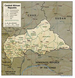 Map Of Central African Republic
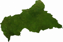 Satellite image of Central African Republic
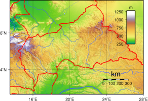 Topography of Central African Republic
The Central African Republic is a landlocked nation within the interior of the African continent. It is bordered by the countries of Cameroon, Chad, Sudan, South Sudan, the Democratic Republic of the Congo and the Republic of the Congo. Much of the country consists of flat, or rolling plateau savanna, about 1,640 feet (500 m) above sea level. In the northeast are the Fertit Hills, and there are scattered hills in southwest part of the country. To the northwest is the Yade Massif, a granite plateau with an altitude of 3,750 feet (1,143 m).
At 240,519 square miles (622,941 km2), the Central African Republic is the world's 43rd-largest country (after Somalia). It is comparable in size to Ukraine, and is somewhat smaller than the US state of Texas.
Much of the southern border is formed by tributaries of the Congo River, with the Mbomou River in the east merging with the Uele River to form the Ubangi River. In the west, the Sangha River flows through part of the country. The eastern border lies along the edge of the Nile river watershed.
Estimates of the amount of the country covered by forest ranges up to 8%, with the densest parts in the south. The forest is highly diverse, and includes commercially important species of Ayous, Sapelli and Sipo. The deforestation rate is 0.4% per annum, and lumber poaching is commonplace.
Contents
Climate
Main article: Climate of the Central African RepublicThe climate of the C.A.R. is generally tropical. The northern areas are subject to harmattan winds, which are hot, dry, and carry dust. The northern regions have been subject to desertification, and the northeast is desert[clarification needed]. The remainder of the country is prone to flooding from nearby rivers.
Notes
Location: Central Africa, north of Democratic Republic of the Congo
Geographic coordinates: 7°N 21°E / 7°N 21°E
Map references: Africa
Area:
total: 622,984 km²
land: 622,984 km²
water: 0 km²Area - comparative:
Land boundaries:
total: 5,203 km
border countries: Cameroon 797 km, Chad 1,197 km, Democratic Republic of the Congo 1,577 km, Republic of the Congo 467 km, Sudan 483 km and South Sudan 682 kmCoastline: 0 km (landlocked)
Maritime claims: none (landlocked)
Terrain: vast, flat to rolling, monotonous plateau; scattered hills in northeast and southwest
Elevation extremes:
lowest point: Oubangui River 335 m
highest point: Mont Ngaoui 1,420 mNatural resources: diamonds, uranium, timber, gold, petroleum, hydropower
Land use:
arable land: 3%
permanent crops: 0%
permanent pastures: 5%
forests and woodland: 75%
other: 17% (1993 est.)Irrigated land: 20 km² (2003)
Total renewable water resources: 144.4 km3 (2003)
Natural hazards: hot, dry, dusty harmattan winds affect northern areas; floods are common
Environment - current issues: tap water is not potable; poaching has diminished its reputation as one of the last great wildlife refuges; desertification; deforestation
Environment - international agreements:
party to: Biodiversity, Climate Change, Desertification, Endangered Species, Nuclear Test Ban, Ozone Layer Protection, Tropical Timber 94
signed, but not ratified: Law of the SeaGeography - note: landlocked; almost the precise center of Africa
Extreme points
This is a list of the extreme points of the Central African Republic, the points that are farther north, south, east or west than any other location.
- Northernmost point - unnamed location in the Aoukalé river on the border with Chad, Vakaga province
- Easternmost point - unnamed location immediately east of the tripoint with Sudan and the Democratic Republic of the Congo and south of the town of Ezo in Sudan, Haut-Mbomou province
- Southernmost point - the tripoint with Cameroon and the Republic of Congo, Sangha province
- Westernmost point - unnamed location on the border with Cameroon west of the town of Koundé in Central African Republic near Cameroon's Lokoti to Garoua Boulai road, Nana Mambéré province
See also
Sovereign
states- Algeria
- Angola
- Benin
- Botswana
- Burkina Faso
- Burundi
- Cameroon
- Cape Verde
- Central African Republic
- Chad
- Comoros
- Democratic Republic of the Congo
- Republic of the Congo
- Côte d'Ivoire (Ivory Coast)
- Djibouti
- Egypt
- Equatorial Guinea
- Eritrea
- Ethiopia
- Gabon
- The Gambia
- Ghana
- Guinea
- Guinea-Bissau
- Kenya
- Lesotho
- Liberia
- Libya
- Madagascar
- Malawi
- Mali
- Mauritania
- Mauritius
- Morocco
- Mozambique
- Namibia
- Niger
- Nigeria
- Rwanda
- São Tomé and Príncipe
- Senegal
- Seychelles
- Sierra Leone
- Somalia
- South Africa
- South Sudan
- Sudan
- Swaziland
- Tanzania
- Togo
- Tunisia
- Uganda
- Zambia
- Zimbabwe
States with limited
recognition- Sahrawi Arab Democratic Republic
- Somaliland
Dependencies and
other territories- Canary Islands / Ceuta / Melilla / Plazas de soberanía (Spain)
- Madeira (Portugal)
- Mayotte / Réunion (France)
- Saint Helena / Ascension Island / Tristan da Cunha (United Kingdom)
- Western Sahara
Climate of Africa Sovereign
states- Algeria
- Angola
- Benin
- Botswana
- Burkina Faso
- Burundi
- Cameroon
- Cape Verde
- Central African Republic
- Chad
- Comoros
- Democratic Republic of the Congo
- Republic of the Congo
- Côte d'Ivoire (Ivory Coast)
- Djibouti
- Egypt
- Equatorial Guinea
- Eritrea
- Ethiopia
- Gabon
- The Gambia
- Ghana
- Guinea
- Guinea-Bissau
- Kenya
- Lesotho
- Liberia
- Libya
- Madagascar
- Malawi
- Mali
- Mauritania
- Mauritius
- Morocco
- Mozambique
- Namibia
- Niger
- Nigeria
- Rwanda
- São Tomé and Príncipe
- Senegal
- Seychelles
- Sierra Leone
- Somalia
- South Africa
- South Sudan
- Sudan
- Swaziland
- Tanzania
- Togo
- Tunisia
- Uganda
- Zambia
- Zimbabwe
States with limited
recognition- Sahrawi Arab Democratic Republic
- Somaliland
Dependencies and
other territories- Canary Islands / Ceuta / Melilla / Plazas de soberanía (Spain)
- Madeira (Portugal)
- Mayotte / Réunion (France)
- Saint Helena / Ascension Island / Tristan da Cunha (United Kingdom)
- Western Sahara
 This article incorporates public domain material from websites or documents of the CIA World Factbook.Categories:


Wikimedia Foundation. 2010.