- Geography of Equatorial Guinea
-
República de Guinea Ecuatorial
République de la Guinée Équatoriale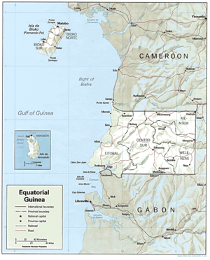
Continent Africa Geographic coordinates 2°00′N 10°00′E / 2°N 10°E Area
- Total
- % waterRanked 141st
28,051 km²
NegligibleCoastline 296 km Highest point Pico Basile, 3,008 m Lowest point Atlantic Ocean, 0 m Longest river Uola River Land Use
- Arable land
- Permanent
crops
- Permanent
pastures
- Forests and
woodlands
- Other
5 %4 % 4 % 46 %
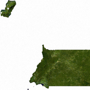
41 % (1993 est.)Climate: Tropical add more need ideas Natural resources petroleum, timber, small unexploited deposits of gold, manganese, uranium Environmental issues drinking water, desertification  Satellite image of Equatorial Guinea
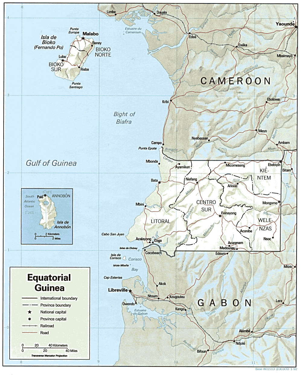
The Republic of Equatorial Guinea is located in west central Africa. Bioko Island lies about 40 kilometers (24.9 mi) from Cameroon. Annobón Island lies about 595 kilometres (370 mi) southwest of Bioko Island. The larger continental region of Rio Muni lies between Cameroon and Gabon on the mainland; it includes the islands of Corisco, Elobey Grande, Elobey Chico, and adjacent islets.
Bioko Island, called Fernando Po until the 1970s, is the largest island in the Gulf of Guinea - 2,017 square kilometers (779 sq mi). It is shaped like a boot, with two large volcanic formations separated by a valley that bisects the island at its narrowest point. The 195-kilometer (121 mi) coastline is steep and rugged in the south but lower and more accessible in the north, with excellent harbors at Malabo and Luba, and several scenic beaches between those towns.
On the continent, Rio Muni covers 26,003 square kilometers (10,040 sq mi). The coastal plain gives way to a succession of valleys separated by low hills and spurs of the Crystal Mountains. The Rio Benito (Mbini) which divides Rio Muni in half, is unnavigable except for a 20-kilometer stretch at its estuary. Temperatures and humidity in Rio Muni are generally lower than on Bioko Island.
Annobon Island, named for its discovery on New Year's Day 1472, is a small volcanic island covering 18 square kilometers (6.9 sq mi). The coastline is abrupt except in the north; the principal volcanic cone contains a small lake. Most of the estimated 1,900 inhabitants are fisherman specializing in traditional, smallscale tuna fishing and whaling. The climate is tropical—heavy rainfall, high humidity, and frequent seasonal changes with violent windstorms.
Location: Western Africa, bordering the Bight of Biafra, between Cameroon and Gabon.
Contents
Boundaries
Equatorial Guinea's land boundaries total 539 km. It borders Cameroon (189 km) in the north and Gabon (350 km) in the east and south.
Maritime claims:
exclusive economic zone: 200 nmi (370.4 km; 230.2 mi)
territorial sea: 12 nmi (22.2 km; 13.8 mi)
Climate
The climate of both the continental region and the islands is typically equatorial, with high temperatures, heavy rainfall, and much cloud cover most of the year. Local variations are due to differences in altitude and proximity to the sea. The wet seasons in the continental region are from February to June and from September to December. Rainfall is higher on the coast than inland. In Bata the rainiest months are September, October, and November, with rainfall averaging more than 94 in (2,388 mm) a year. At Calatrava, farther south on the coast, it sometimes reaches 180 in (4,572 mm). Inland, however, rainfall diminishes; Mikomeseng, for example, receives only about 58 in (1,473 mm). The average annual temperature is about 79 °F (26.1 °C) and is fairly constant throughout the year. The temperature maxima are somewhat lower than in Bioko. The relative humidity, however, is higher than in Bioko. Bioko has a rather debilitating climate. The so-called dry season lasts from November to March, and the rest of the year is rainy. The average annual temperature of about 77 °F (25 °C) varies little throughout the year. Afternoon temperatures reach the high 80s °F (low 30s °C) and drop to only about 70 °F (21.1 °C) at night. Most of the time the sky is cloudy and overcast. Extreme rainfall occurs in the south, with rain brought by monsoon winds amounting to about 450 in (11,430 mm) a year around San Antonio de Ureca.
Terrain
Coastal plains rise to interior hills; islands are volcanic
Irrigated land: NA km²
Natural hazards: violent windstorms, flash floods
Environment - current issues: tap water is not potable; desertification
Environment - international agreements:
party to: Biodiversity, Desertification, Endangered Species, Law of the Sea, Ship Pollution
signed, but not ratified: none of the selected agreements
Geography - note: insular and continental regions rather widely separated
Extreme points
This is a list of the extreme points of Equatorial Guinea, the points that are farther north, south, east or west than any other location.
- Northern-most point - Punta Europa, Bioko Island
- Eastern-most point - the eastern section of the border with Gabon*
- Southern-most point - A Dyibó, Annobón Island
- Western-most point - Punta Dyiscoj, Annobón Island
- Note: technically Equatorial Guinea does not have an eastern-most point as its eastern border is formed by a straight line between the 11° and 12° of latitude
See also
Sovereign
states- Algeria
- Angola
- Benin
- Botswana
- Burkina Faso
- Burundi
- Cameroon
- Cape Verde
- Central African Republic
- Chad
- Comoros
- Democratic Republic of the Congo
- Republic of the Congo
- Côte d'Ivoire (Ivory Coast)
- Djibouti
- Egypt
- Equatorial Guinea
- Eritrea
- Ethiopia
- Gabon
- The Gambia
- Ghana
- Guinea
- Guinea-Bissau
- Kenya
- Lesotho
- Liberia
- Libya
- Madagascar
- Malawi
- Mali
- Mauritania
- Mauritius
- Morocco
- Mozambique
- Namibia
- Niger
- Nigeria
- Rwanda
- São Tomé and Príncipe
- Senegal
- Seychelles
- Sierra Leone
- Somalia
- South Africa
- South Sudan
- Sudan
- Swaziland
- Tanzania
- Togo
- Tunisia
- Uganda
- Zambia
- Zimbabwe
States with limited
recognition- Sahrawi Arab Democratic Republic
- Somaliland
Dependencies and
other territories- Canary Islands / Ceuta / Melilla / Plazas de soberanía (Spain)
- Madeira (Portugal)
- Mayotte / Réunion (France)
- Saint Helena / Ascension Island / Tristan da Cunha (United Kingdom)
- Western Sahara
Climate of Africa Sovereign
states- Algeria
- Angola
- Benin
- Botswana
- Burkina Faso
- Burundi
- Cameroon
- Cape Verde
- Central African Republic
- Chad
- Comoros
- Democratic Republic of the Congo
- Republic of the Congo
- Côte d'Ivoire (Ivory Coast)
- Djibouti
- Egypt
- Equatorial Guinea
- Eritrea
- Ethiopia
- Gabon
- The Gambia
- Ghana
- Guinea
- Guinea-Bissau
- Kenya
- Lesotho
- Liberia
- Libya
- Madagascar
- Malawi
- Mali
- Mauritania
- Mauritius
- Morocco
- Mozambique
- Namibia
- Niger
- Nigeria
- Rwanda
- São Tomé and Príncipe
- Senegal
- Seychelles
- Sierra Leone
- Somalia
- South Africa
- South Sudan
- Sudan
- Swaziland
- Tanzania
- Togo
- Tunisia
- Uganda
- Zambia
- Zimbabwe
States with limited
recognition- Sahrawi Arab Democratic Republic
- Somaliland
Dependencies and
other territories- Canary Islands / Ceuta / Melilla / Plazas de soberanía (Spain)
- Madeira (Portugal)
- Mayotte / Réunion (France)
- Saint Helena / Ascension Island / Tristan da Cunha (United Kingdom)
- Western Sahara
Categories:
Wikimedia Foundation. 2010.