- Geography of Rwanda
-
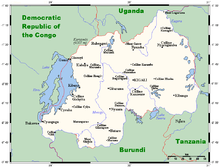
Rwanda is a landlocked country located in Central Africa, to the east of the Democratic Republic of the Congo. Its countryside consists of grasslands and rolling hills, and it has a temperate climate.
Contents
Political geography
Rwanda borders Burundi for 290 km, the Democratic Republic of the Congo for 217 km, Tanzania for 217 km, and Uganda for 169 km.
Physical geography
Rwanda has an area of 26 thousands square kilometers, of which 3 percent is water.
Climate
Although Rwanda is located only two degrees south of the equator, Rwanda's high elevation makes the climate temperate. The average daily temperature near Lake Kivu, at an altitude of 4,800 feet (1,463 m) is 73 °F (22.8 °C). During the two rainy seasons (February-May and September-December), heavy downpours occur almost daily, alternating with sunny weather. Annual rainfall averages 800 mm (31.5 in) but is generally heavier in the western and northwestern mountains than in the eastern savannas.
Natural Resources
Rwanda possesses the following natural resources:
- gold
- cassiterite (tin ore)
- wolframite (tungsten ore)
- methane
- hydropower
- coffee
- tea
- arable land
The use of land in Rwanda is largely for arable land, and other purposes. 40 km² of land in Rwanda is irrigated. The table below describes the land use in Rwanda, as of 2005.
Land use Use Percentage of Area arable land 45.56 permanent crops 10.25 plus the average height other 44.19 Environment
Natural hazards in Rwanda include periodic droughts and the volcanic activity of the Virunga Mountains, located in the northwest of the country, along the border with the Democratic Republic of the Congo.
Current issues
Current issues concerning the environment in Rwanda include: the result of uncontrolled deforestation for fuel, overgrazing, soil exhaustion and widespread poaching.
International agreements
Rwanda is a party to the following international agreements:
- Biodiversity
- Climate Change
- Desertification
- Endangered Species
- Nuclear Test Ban
Rwanda has signed, but not ratified the United Nations Convention on the Law of the Sea.
Extreme points
This is a list of the extreme points of Rwanda, the points that are farther north, south, east or west than any other location.
- Northern-most point - unnamed location on the border with Uganda immediately north-west of the village of Kagitumba, Eastern province
- Eastern-most point - unnamed location on the border with Tanzania in the Kagera river, Eastern province
- Southern-most point - unnamed location on the border with Burundi, Southern province
- Western-most point - unnamed location on the border with the Democratic Republic of the Congo in the Ruzizi river immediately south of the DRC town of Bukavu, Western province
See also
Coordinates: 2°00′S 30°00′E / 2°S 30°E
Sovereign
states- Algeria
- Angola
- Benin
- Botswana
- Burkina Faso
- Burundi
- Cameroon
- Cape Verde
- Central African Republic
- Chad
- Comoros
- Democratic Republic of the Congo
- Republic of the Congo
- Côte d'Ivoire (Ivory Coast)
- Djibouti
- Egypt
- Equatorial Guinea
- Eritrea
- Ethiopia
- Gabon
- The Gambia
- Ghana
- Guinea
- Guinea-Bissau
- Kenya
- Lesotho
- Liberia
- Libya
- Madagascar
- Malawi
- Mali
- Mauritania
- Mauritius
- Morocco
- Mozambique
- Namibia
- Niger
- Nigeria
- Rwanda
- São Tomé and Príncipe
- Senegal
- Seychelles
- Sierra Leone
- Somalia
- South Africa
- South Sudan
- Sudan
- Swaziland
- Tanzania
- Togo
- Tunisia
- Uganda
- Zambia
- Zimbabwe
States with limited
recognition- Sahrawi Arab Democratic Republic
- Somaliland
Dependencies and
other territories- Canary Islands / Ceuta / Melilla / Plazas de soberanía (Spain)
- Madeira (Portugal)
- Mayotte / Réunion (France)
- Saint Helena / Ascension Island / Tristan da Cunha (United Kingdom)
- Western Sahara
Climate of Africa Sovereign
states- Algeria
- Angola
- Benin
- Botswana
- Burkina Faso
- Burundi
- Cameroon
- Cape Verde
- Central African Republic
- Chad
- Comoros
- Democratic Republic of the Congo
- Republic of the Congo
- Côte d'Ivoire (Ivory Coast)
- Djibouti
- Egypt
- Equatorial Guinea
- Eritrea
- Ethiopia
- Gabon
- The Gambia
- Ghana
- Guinea
- Guinea-Bissau
- Kenya
- Lesotho
- Liberia
- Libya
- Madagascar
- Malawi
- Mali
- Mauritania
- Mauritius
- Morocco
- Mozambique
- Namibia
- Niger
- Nigeria
- Rwanda
- São Tomé and Príncipe
- Senegal
- Seychelles
- Sierra Leone
- Somalia
- South Africa
- South Sudan
- Sudan
- Swaziland
- Tanzania
- Togo
- Tunisia
- Uganda
- Zambia
- Zimbabwe
States with limited
recognition- Sahrawi Arab Democratic Republic
- Somaliland
Dependencies and
other territories- Canary Islands / Ceuta / Melilla / Plazas de soberanía (Spain)
- Madeira (Portugal)
- Mayotte / Réunion (France)
- Saint Helena / Ascension Island / Tristan da Cunha (United Kingdom)
- Western Sahara
 Rwanda topics
History Politics Geography Economy and infrastructure Demographics and society Culture Index • Portal Categories:
Wikimedia Foundation. 2010.


