- Geography of Mayotte
-
Mayotte Native name: Mahoré
Nickname: Grande-Terre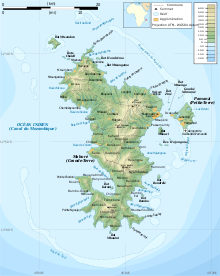
Map of Mayotte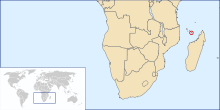
Geography Location Mozambique Channel Coordinates 12°50′S 45°10′E / 12.833°S 45.167°E Archipelago Comoro Islands Area 374 km2 (144.4 sq mi) Length 39 km (24.2 mi) Width 22 km (13.7 mi) Coastline 185.2 km (115.08 mi) Highest elevation 660 m (2,170 ft) Highest point Benara Country FranceOverseas collectivity  Mayotte
Largest city Mamoudzou (pop. 53,022) Demographics Population 186,452 (as of 2007) Density 498.53 /km2 (1,291.19 /sq mi) Ethnic groups Mahoran Mayotte is an island of volcanic origin in the northernmost Mozambique Channel, about one-half of the way from northern Madagascar to northern Mozambique. Mayotte is part of the Comoro Islands, and like them is the result of a former hot spot, the oldest of the Comoros archipelago, formed about 7.7 mya.[1] Mayotte has an area of 374 square kilometres, and a coastline of length 185.2 km. Its maritime claims are an exclusive economic zone of 200 nautical miles, and a territorial sea of 12 nm.
Contents
Terrain
The terrain of the island is undulating, with deep ravines and ancient volcanic peaks. The lowest point is the Indian Ocean, and the highest is Benara, at 660 m.
Climate
The climate of Mayotte is a tropical, marine climate. Between November and May, there is a hot, humid and rainy season, during the northeastern monsoon. At this time of the year, a hazard is posed by cyclones. Between May and November, there is a cooler, dry season.
See also
- List of islands of Mayotte
Notes
- ^ Thomas Schlüter, Martin H. Trauth, Geological Atlas of Africa, s.v. "The Comoros", 2008:74.
External links
Coordinates: 12°50′S 45°10′E / 12.833°S 45.167°E
Sovereign
states- Algeria
- Angola
- Benin
- Botswana
- Burkina Faso
- Burundi
- Cameroon
- Cape Verde
- Central African Republic
- Chad
- Comoros
- Democratic Republic of the Congo
- Republic of the Congo
- Côte d'Ivoire (Ivory Coast)
- Djibouti
- Egypt
- Equatorial Guinea
- Eritrea
- Ethiopia
- Gabon
- The Gambia
- Ghana
- Guinea
- Guinea-Bissau
- Kenya
- Lesotho
- Liberia
- Libya
- Madagascar
- Malawi
- Mali
- Mauritania
- Mauritius
- Morocco
- Mozambique
- Namibia
- Niger
- Nigeria
- Rwanda
- São Tomé and Príncipe
- Senegal
- Seychelles
- Sierra Leone
- Somalia
- South Africa
- South Sudan
- Sudan
- Swaziland
- Tanzania
- Togo
- Tunisia
- Uganda
- Zambia
- Zimbabwe
States with limited
recognition- Sahrawi Arab Democratic Republic
- Somaliland
Dependencies and
other territories- Canary Islands / Ceuta / Melilla / Plazas de soberanía (Spain)
- Madeira (Portugal)
- Mayotte / Réunion (France)
- Saint Helena / Ascension Island / Tristan da Cunha (United Kingdom)
- Western Sahara
Climate of Africa Sovereign
states- Algeria
- Angola
- Benin
- Botswana
- Burkina Faso
- Burundi
- Cameroon
- Cape Verde
- Central African Republic
- Chad
- Comoros
- Democratic Republic of the Congo
- Republic of the Congo
- Côte d'Ivoire (Ivory Coast)
- Djibouti
- Egypt
- Equatorial Guinea
- Eritrea
- Ethiopia
- Gabon
- The Gambia
- Ghana
- Guinea
- Guinea-Bissau
- Kenya
- Lesotho
- Liberia
- Libya
- Madagascar
- Malawi
- Mali
- Mauritania
- Mauritius
- Morocco
- Mozambique
- Namibia
- Niger
- Nigeria
- Rwanda
- São Tomé and Príncipe
- Senegal
- Seychelles
- Sierra Leone
- Somalia
- South Africa
- South Sudan
- Sudan
- Swaziland
- Tanzania
- Togo
- Tunisia
- Uganda
- Zambia
- Zimbabwe
States with limited
recognition- Sahrawi Arab Democratic Republic
- Somaliland
Dependencies and
other territories- Canary Islands / Ceuta / Melilla / Plazas de soberanía (Spain)
- Madeira (Portugal)
- Mayotte / Réunion (France)
- Saint Helena / Ascension Island / Tristan da Cunha (United Kingdom)
- Western Sahara
Categories:


Wikimedia Foundation. 2010.