- Geography of Cameroon
-
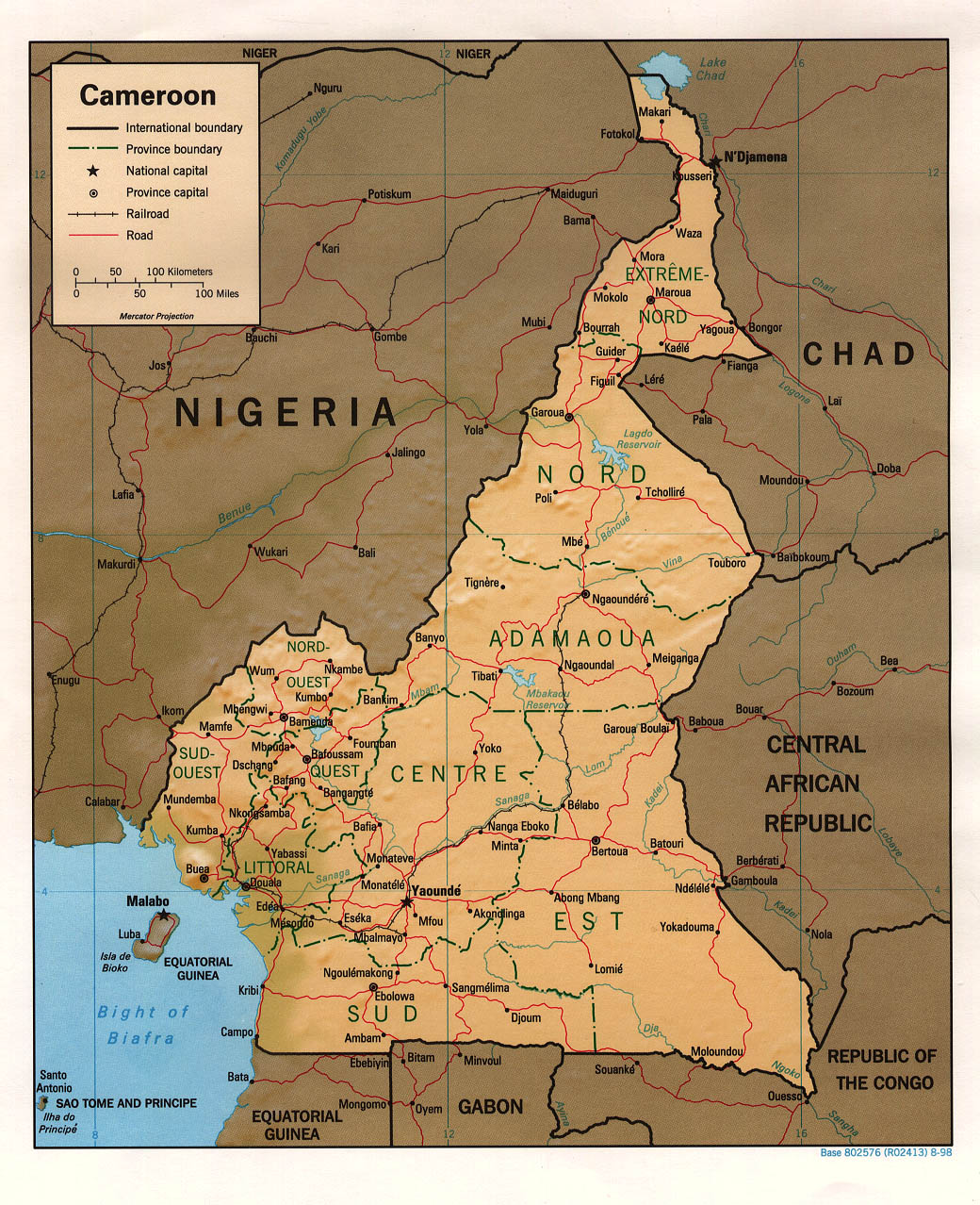
 Map Of Cameroon
At 183,568 sq mi (475,440 km2), Cameroon is the world's 54th-largest country. It is comparable in size to Papua New Guinea, and somewhat larger than the U.S. state of California. Cameroon's landmass is 181,252 sq mi (469,440 km2), with 2,317 sq mi (6,000 km2) of water.
The country is located in Central and West Africa, bordering the Bight of Biafra, between Equatorial Guinea and Nigeria.
Cameroon is sometimes described as "Africa in miniature" because it exhibits all the major climates and vegetation of the continent: mountains, desert, rain forest, savanna grassland, and ocean coastland. Cameroon can be divided into five geographic zones. These are distinguished by dominant physical, climatic, and vegetative features.
Contents
Natural regions
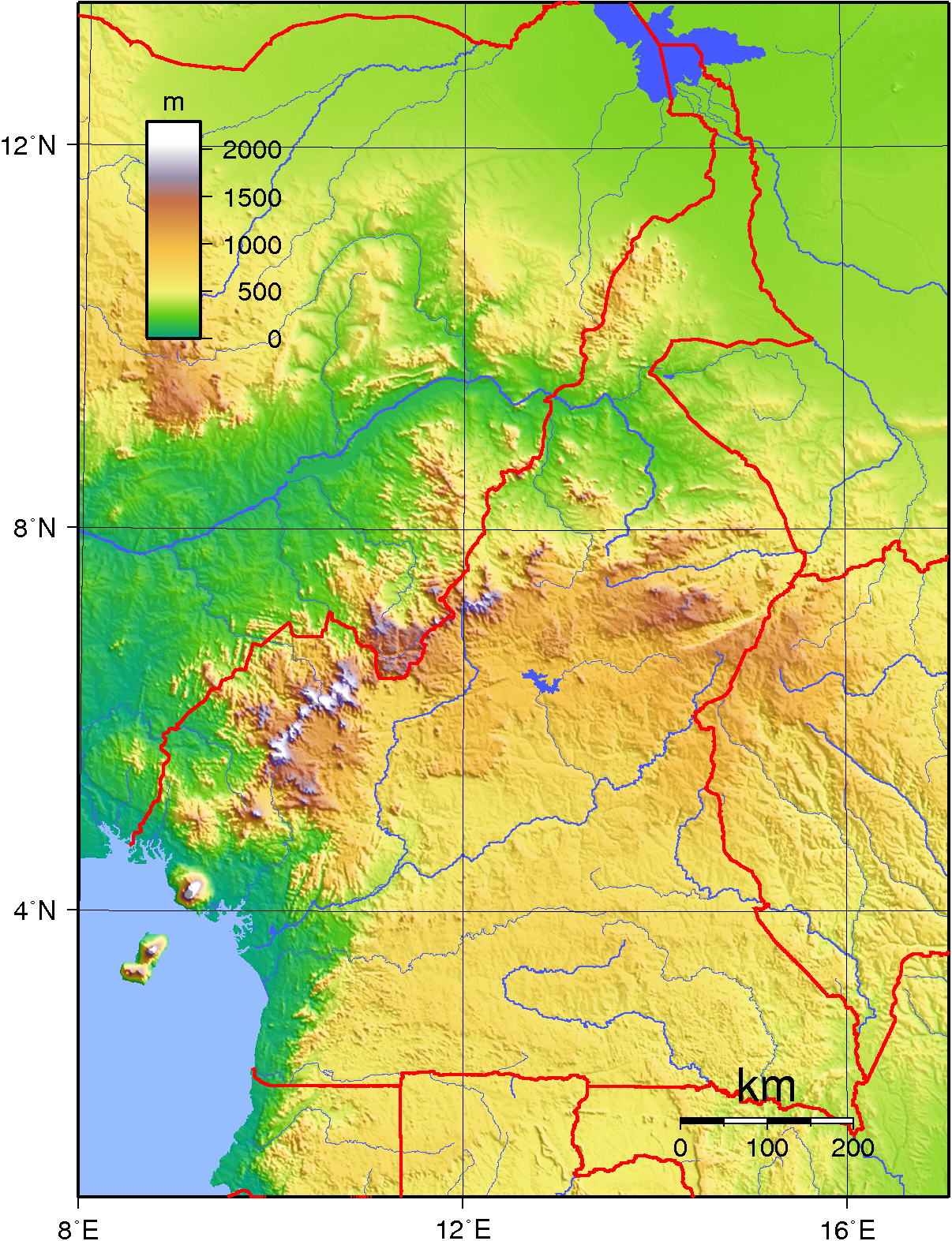
 Topography of Cameroon
 Satellite image of Cameroon
Cameroon's coastal plain extends 10 to 50 miles (16.1 to 80.5 km) inland from the Gulf of Guinea (part of the Atlantic Ocean) to the edge of a plateau. In the former western state, however, the mass of Mount Cameroon reaches almost to the sea. The plain is densely forested including areas of Central African mangroves especially around Douala and in the estuary of the Cross River on the border with Nigeria.
The low South Cameroon Plateau, rising from the coastal plain and dominated by tropical rain forest, has an average elevation of 1,500 to 2,000 feet (457 to 610 m). It is less humid than the coast.
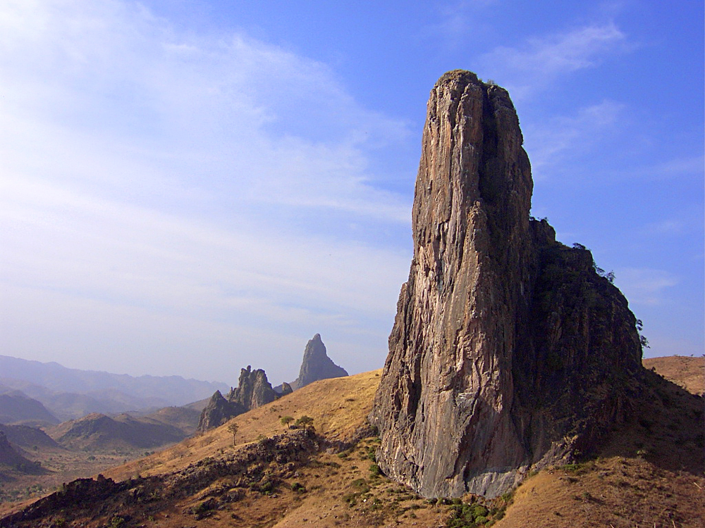
In western Cameroon is an irregular chain of mountains, hills, and plateaus that extend from Mt. Cameroon almost to Lake Chad at the northern tip of the country. This region includes the Bamenda, Bamiléké, and Mambilla highlands. It also contains some of the country's most fertile soils, notably around volcanic Mt. Cameroon. This area of tropical forest has been categorised by the World Wildlife Fund as the Cameroonian Highlands forests ecoregion with Mount Cameroon considered separately because as an active volcano it has a distinct environment from the other mountains.
From the forested southern plateau the land rises northward to the grassy, rugged Adamaoua (Adamawa) highlands. Stretching across Cameroon from the western mountain area, the Adamaoua forms a barrier between the north and south. Its average elevation is 3,400 feet (1,036 m).
The northern savanna plain extends from the edge of the Adamaoua to Lake Chad. Its characteristic vegetation is scrub and grass. This is region of sparse rainfall and high median temperatures has been included as part of the East Sudanian savanna ecoregion.
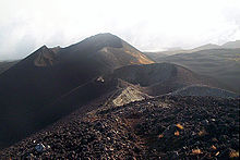 Mount Cameroon craters
Climate
The climate varies with terrain, from tropical along the coast to semiarid and hot in the north. Exceedingly hot and humid, the coastal belt includes some of the wettest places on earth. For example, Debundscha, at the base of Mt. Cameroon, has an average annual rainfall of 405 inches (10,287 mm).[1]
Rivers
The country has four patterns of drainage. In the south, the principal rivers—the Wouri, Sanaga, Nyong, and Ntem—flow southwestward or westward directly into the Gulf of Guinea. The Dja and Kadeï, however, drain southeastward into the Congo River. In northern Cameroon, the Benoué River (Benue) runs north and west, eventually into the Niger, while the Logone River flows northward into Lake Chad.
Only part of Lake Chad lies within Cameroon. The rest belongs to Chad, Nigeria, and Niger. The lake varies in size according to seasonal rainfall.
Some of the borders of Cameroon follow rivers, including the Aïna River and Ntem River.
Data
Location: Central Africa, bordering the Bight of Biafra, between Equatorial Guinea and Nigeria
Geographic coordinates: 6°N 12°E / 6°N 12°E
Map references: Africa
Area:
total: 475,440 km²
land: 472,710 km²
water: 2,730 km²Area - comparative: slightly larger than California
Land boundaries:
total: 4,591 km
border countries: Central African Republic 797 km, Chad 1,094 km, Republic of the Congo 523 km, Equatorial Guinea 189 km, Gabon 298 km, Nigeria 1,690 kmCoastline: 402 km
Maritime claims:
territorial sea: 50 nmi (92.6 km; 57.5 mi)Terrain: diverse, with coastal plain in southwest, dissected plateau in center, mountains in west, plains in north
Elevation extremes:
lowest point: Atlantic Ocean 0 m
highest point: Fako (on. Mt. Cameroon) 4,095 mNatural resources: petroleum, bauxite, iron ore, timber, hydropower
Land use:
arable land: 12.54%
permanent crops: 2.52%
other: 84.94% (2005)Irrigated land: 260 km² (2003)

Total renewable water resources: 285.5 km³ (2003)
Freshwater withdrawal (domestic/industrial/agricultural):
total: 0.99 km³/yr (18%/8%/74%)
per capita: 61 m³/yr (2000)Natural hazards: Recent limnic eruptions with release of carbon dioxide:
- from Lake Monoun, August 15, 1984, killing 37
- from Lake Nyos, August 21, 1986, killing as many as 1800
Environment - current issues: water-borne diseases are prevalent; deforestation; overgrazing; desertification; poaching; overfishing
Environment - international agreements:
party to: Biodiversity, Climate Change, Desertification, Endangered Species, Law of the Sea, Ozone Layer Protection, Tropical Timber 83, Tropical Timber 94
signed, but not ratified: Nuclear Test BanGeography - note: sometimes referred to as 'the hinge of Africa;' throughout the country there are areas of thermal springs and indications of current or prior volcanic activity; Mount Cameroon, the highest mountain in Sub-Saharan west Africa, is an active volcano
Extreme points
This is a list of the extreme points of Cameroon, the points that are farther north, south, east or west than any other location.
- Northernmost point - unnamed peninsula jutting into lake Chad, Far North province
- Easternmost point - unnamed location on the border with the Republic of Congo in the Sangha river opposite the Congolese town of Bomassa, East region
- Southernmost point - unnamed headland at the confluence on the Sangha river and the Ngoko river immediately north of the Congolese town of Ouesso, East region
- Westernmost point - unnamed point on Akwabana island, Southwest region
See also
Notes
- ^ Highest Average Annual Precipitation Extremes. Global Measured Extremes of Temperature and Precipitation, National Climatic Data Center. August 9, 2004. Last accessed November 7, 2006.
References
 This article incorporates public domain material from websites or documents of the CIA World Factbook.
 Cameroon topics
History Baka · Mandara kingdom · German Kamerun · French Cameroun · British Cameroons · West Africa Campaign · Union of the Peoples of CameroonPolitics Geography Economy and infrastructure Agriculture · Airports · Central African CFA franc · Communications · Companies · Mining · Tourism · TransportCulture and society Communications · Cuisine · Demographics · Education · Ethnic groups · Football · Health · Holidays · Languages · Media · Music · Religion · Rugby unionList of Cameroon-related topics Sovereign
states- Algeria
- Angola
- Benin
- Botswana
- Burkina Faso
- Burundi
- Cameroon
- Cape Verde
- Central African Republic
- Chad
- Comoros
- Democratic Republic of the Congo
- Republic of the Congo
- Côte d'Ivoire (Ivory Coast)
- Djibouti
- Egypt
- Equatorial Guinea
- Eritrea
- Ethiopia
- Gabon
- The Gambia
- Ghana
- Guinea
- Guinea-Bissau
- Kenya
- Lesotho
- Liberia
- Libya
- Madagascar
- Malawi
- Mali
- Mauritania
- Mauritius
- Morocco
- Mozambique
- Namibia
- Niger
- Nigeria
- Rwanda
- São Tomé and Príncipe
- Senegal
- Seychelles
- Sierra Leone
- Somalia
- South Africa
- South Sudan
- Sudan
- Swaziland
- Tanzania
- Togo
- Tunisia
- Uganda
- Zambia
- Zimbabwe
States with limited
recognition- Sahrawi Arab Democratic Republic
- Somaliland
Dependencies and
other territories- Canary Islands / Ceuta / Melilla / Plazas de soberanía (Spain)
- Madeira (Portugal)
- Mayotte / Réunion (France)
- Saint Helena / Ascension Island / Tristan da Cunha (United Kingdom)
- Western Sahara
Climate of Africa Sovereign
states- Algeria
- Angola
- Benin
- Botswana
- Burkina Faso
- Burundi
- Cameroon
- Cape Verde
- Central African Republic
- Chad
- Comoros
- Democratic Republic of the Congo
- Republic of the Congo
- Côte d'Ivoire (Ivory Coast)
- Djibouti
- Egypt
- Equatorial Guinea
- Eritrea
- Ethiopia
- Gabon
- The Gambia
- Ghana
- Guinea
- Guinea-Bissau
- Kenya
- Lesotho
- Liberia
- Libya
- Madagascar
- Malawi
- Mali
- Mauritania
- Mauritius
- Morocco
- Mozambique
- Namibia
- Niger
- Nigeria
- Rwanda
- São Tomé and Príncipe
- Senegal
- Seychelles
- Sierra Leone
- Somalia
- South Africa
- South Sudan
- Sudan
- Swaziland
- Tanzania
- Togo
- Tunisia
- Uganda
- Zambia
- Zimbabwe
States with limited
recognition- Sahrawi Arab Democratic Republic
- Somaliland
Dependencies and
other territories- Canary Islands / Ceuta / Melilla / Plazas de soberanía (Spain)
- Madeira (Portugal)
- Mayotte / Réunion (France)
- Saint Helena / Ascension Island / Tristan da Cunha (United Kingdom)
- Western Sahara
Categories:


Wikimedia Foundation. 2010.