- Geography of Réunion
-
Réunion 
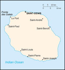
Map of Réunion
Geography Location Indian Ocean Coordinates 21°06′S 55°36′E / 21.1°S 55.6°E Area 2,512 km2 (969.9 sq mi) Coastline 207 km (128.6 mi) Highest elevation 3,069 m (10,069 ft) Highest point Piton des Neiges Country FranceOverseas department  Réunion
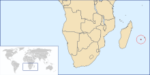
Largest city Saint-Denis (pop. 133,700) Demographics Population 793,000 (as of 2007) Density 315.68 /km2 (817.61 /sq mi) Ethnic groups Creoles, French, African, Tamil, other Indians, Malagasy, Chinese and Vietnamese Réunion is an island in Southern Africa, in the Indian Ocean, east of Madagascar. It is an overseas region of France. The total area of the island is 2,512 km², of which 10 km² is water. The island has a coastline of 207 km. The maritime claims of Réunion include an exclusive economic zone of 200 nautical miles, and a territorial sea of 12 nautical miles (22 km).
Contents
Climate
The climate in Réunion is tropical, but temperature moderates with elevation. The weather is cool and dry from May to November, and hot and rainy from November to April. The terrain is mostly rugged and mountainous, with fertile lowlands along the coast. The lowest point is the Indian Ocean and the highest is Piton des Neiges at 3,069 m.
Natural resources
Réunion's natural resources are fish, arable land and hydropower. As of 1993, 60 km² of the land is irrigated. The use of the land, as of 1993, is described in the table below:
Land use Use Percentage of Area arable land 17 permanent crops 2 permanent pastures 5 forests and woodland 35 other 41 Natural hazards
Local natural hazards include: periodic, devastating cyclones (December to April), and Piton de la Fournaise (2,631 m) on the southeastern coast is an active volcano.
External links
Sovereign
states- Algeria
- Angola
- Benin
- Botswana
- Burkina Faso
- Burundi
- Cameroon
- Cape Verde
- Central African Republic
- Chad
- Comoros
- Democratic Republic of the Congo
- Republic of the Congo
- Côte d'Ivoire (Ivory Coast)
- Djibouti
- Egypt
- Equatorial Guinea
- Eritrea
- Ethiopia
- Gabon
- The Gambia
- Ghana
- Guinea
- Guinea-Bissau
- Kenya
- Lesotho
- Liberia
- Libya
- Madagascar
- Malawi
- Mali
- Mauritania
- Mauritius
- Morocco
- Mozambique
- Namibia
- Niger
- Nigeria
- Rwanda
- São Tomé and Príncipe
- Senegal
- Seychelles
- Sierra Leone
- Somalia
- South Africa
- South Sudan
- Sudan
- Swaziland
- Tanzania
- Togo
- Tunisia
- Uganda
- Zambia
- Zimbabwe
States with limited
recognition- Sahrawi Arab Democratic Republic
- Somaliland
Dependencies and
other territories- Canary Islands / Ceuta / Melilla / Plazas de soberanía (Spain)
- Madeira (Portugal)
- Mayotte / Réunion (France)
- Saint Helena / Ascension Island / Tristan da Cunha (United Kingdom)
- Western Sahara
Climate of Africa Sovereign
states- Algeria
- Angola
- Benin
- Botswana
- Burkina Faso
- Burundi
- Cameroon
- Cape Verde
- Central African Republic
- Chad
- Comoros
- Democratic Republic of the Congo
- Republic of the Congo
- Côte d'Ivoire (Ivory Coast)
- Djibouti
- Egypt
- Equatorial Guinea
- Eritrea
- Ethiopia
- Gabon
- The Gambia
- Ghana
- Guinea
- Guinea-Bissau
- Kenya
- Lesotho
- Liberia
- Libya
- Madagascar
- Malawi
- Mali
- Mauritania
- Mauritius
- Morocco
- Mozambique
- Namibia
- Niger
- Nigeria
- Rwanda
- São Tomé and Príncipe
- Senegal
- Seychelles
- Sierra Leone
- Somalia
- South Africa
- South Sudan
- Sudan
- Swaziland
- Tanzania
- Togo
- Tunisia
- Uganda
- Zambia
- Zimbabwe
States with limited
recognition- Sahrawi Arab Democratic Republic
- Somaliland
Dependencies and
other territories- Canary Islands / Ceuta / Melilla / Plazas de soberanía (Spain)
- Madeira (Portugal)
- Mayotte / Réunion (France)
- Saint Helena / Ascension Island / Tristan da Cunha (United Kingdom)
- Western Sahara
Geography Music Transport Other topics Réunion Creole · Wildlife of Réunion · Religion · L'Âme de la France · Réunion Premier League · Communications · Demographics · Flag · History · People · PoliticsCoordinates: 21°06′S 55°36′E / 21.1°S 55.6°E
Categories:- Geography of Réunion
- Réunion geography stubs
Wikimedia Foundation. 2010.
