- Corisco
-
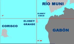
Corisco, or Mandj, is a small island of Equatorial Guinea, located 29 km southwest of the Rio Muni estuary that defines the border with Gabon. Corisco, whose name derives from the Portuguese word for lightning, has an area of just 14 km², and its highest point is 35 meters above the sea.
Originally settled by the Benga people, Corisco was acquired by Spain in 1843, as a result of an arrangement made by J. J. Lerena y Barry with Benga king Bonkoro I. Bonkoro I died in 1846 and was succeeded by his son Bonkoro II, but due to rivalries on the island, Bonkoro II moved to Sao Tome, and Munga I ruled in Corisco 1848 to 1858, his son Munga II taking over, and meeting the explorer Iradier in the 1870s.
In general the Spanish paid little attention to Corisco. In the early part of the 20th century it was part of the administration of Elobey, Annobon, and Corisco, and postage stamps were issued under that name. It became an integral part of Equatorial Guinea upon independence.
Corisco and the surrounding waters of Corisco Bay have become of interest in recent years for their oil prospects. A consortium of Elf Aquitaine and Petrogab began prospecting in 1981. The area is disputed with Gabon because of the perceived value of the oil. In February 2003, Gabonese Defence Minister Ali-Ben Bongo Ondimba visited the islands and re-stated Gabon's claim to them.[1]
References
- ^ "GABON-EQUATORIAL GUINEA: UN mediates dispute over Corisco Bay islands", IRIN, January 23, 2004.
- Max Liniger-Goumaz, Small is not always beautiful: The Story of Equatorial Guinea (1989, ISBN 0-389-20861-2) p. 7, et al.
Coordinates: 0°55′N 9°19′E / 0.917°N 9.317°E
Categories:- Islands of Equatorial Guinea
- Territorial disputes of Equatorial Guinea
- Territorial disputes of Gabon
- Equatorial Guinea–Gabon border
- Equatorial Guinea geography stubs
Wikimedia Foundation. 2010.

