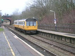
- Dean Lane railway station
-
Dean Lane 
Location Place Newton Heath Area Manchester Operations Pre-grouping Northern Rail Platforms 2 Annual rail passenger usage 2004/05 * 26,132 2005/06 *  28,962
2006/07 *  26,949
2007/08 *  29,228
2008/09 *  46,548
History 17 May 1880 Opened 3 October 2009 Closed for Metrolink conversion Disused railway stations in the United Kingdom * Annual passenger usage based on sales of tickets in stated financial year(s) which end or originate at Dean Lane from Office of Rail Regulation statistics. Please note: methodology may vary year on year. Closed railway stations in Britain
A B C D–F G H–J K–L M–O P–R S T–V W–ZDean Lane railway station opened on 17 May 1880[1] and served Newton Heath, Manchester, England. The station was on the Oldham Loop Line 2½ miles (4 km) north east of Manchester Victoria and was operated and managed by Northern Rail. There were once three stations in Newton Heath: Newton Heath, Dean Lane and Park. The station was 200 yards (180 m) away from the Newton Heath Train Maintenance Depot.
The station closed for the conversion to Metrolink on 3 October 2009 and will re-open as Newton Heath and Moston Metrolink station in Autumn 2011, using only the Manchester-bound platform. Through the station, the track will be singled, allowing Network Rail to use the other line to access the Greater Manchester Waste Disposal facility [2].
Contents
History
From about 1900 to his early death of pneumonia at the age of 44 in 1912, the Station Master was Henry Ainscough, living in the Station Master's house at 52 Dean Lane. (On his death, the family had to move, the cost of living in a tied accommodation).[citation needed]
References
Bibliography
Butt, R.V.J "The Directory of Railway Stations", Patrick Stephens, Sparkford, 1995, ISBN 1-85260-508-1
External links
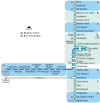
Manchester Lines - City Centre and North, (Past, Present and Future) LegendTo Bury 


To Rochdale Moston 


To Oldham Bowker Vale 


Newton Heath 


Newton Heath and Moston 


Crumpsall 


Central Park 


To Tameside Abraham Moss;Monsall 


Clayton Bridge Woodlands Road 


Park Queens Road 


To Tameside Miles Platting 


Edge Lane 


Clayton Oldham Road 


Sportcity-Velodrome Manchester Victoria 


Holt Town/Sportcity-Stadium Exchange 


To Salford 


New Islington 


Ardwick Exchange Square/Shudehill 


Ashburys High Street; Manchester Piccadilly 


Mayfield;To South Manchester Market Street; Piccadilly Gardens 


To Belle Vue;Gorton Moseley Street;Oxford Road 


To Hyde Road St Peter's Square 


To Tameside Manchester Central/Deansgate-Castlefield 


Deansgate Liverpool Road 


To Salford;Cornbrook 


Cornbrook 


Pomona 


To Eccles 


Trafford Bar To Trafford 


Firswood To Trafford;To Altrincham 


To Chorlton The Oldham Loop Line Stations (anticlockwise from Manchester)
(*) Closed 3 October 2009
Dean Lane (*)
Failsworth (*)
Hollinwood (*)
Oldham Werneth (*)
Oldham Mumps (*)
Derker (*)
Shaw and Crompton (*)
New Hey (*)
Milnrow (*)Proposed Preceding station Manchester Metrolink
Following station Failsworthtowards RochdaleRochdale-Manchester Line towards Manchester Airport
or East DidsburyHistorical railways Failsworth L&YR
Oldham Loop LineMiles Platting Metrolink
Stations City zoneAltrincham LineAltrincham · Brooklands · Cornbrook · Dane Road · Navigation Road · Old Trafford · Sale · Stretford · Timperley · Trafford Bar
Bury LineAbraham Moss · Besses o'th' Barn · Bowker Vale · Bury · Crumpsall · Heaton Park · Prestwich · Radcliffe · Whitefield · Woodlands Road
Eccles LineAnchorage · Broadway · Eccles · Exchange Quay · Harbour City · Ladywell · Langworthy · MediaCityUK · Pomona · Salford Quays · Weaste
South Manchester LineChorlton · Firswood · St Werburgh's Road


Operations OperatorsStagecoach Group · Transport for Greater ManchesterVehiclesFlexity Swift M5000 · T-68History Former operatorsTransferred linesClosed stationsAbandoned plansUnder Construction Bury LineQueens Road
East Manchester LineAshton Moss · Ashton Under Lyne · Ashton West · Audenshaw · Cemetery Road · Clayton Hall · Droylsden · Eastlands City Stadium · Edge Lane · Holt Town · New Islington · Velopark
Oldham & Rochdale LineCentral Park · Derker · Failsworth · Freehold · Hollinwood · Kingsway · Monsall · Milnrow · Newbold · Newton Heath and Moston · Newhey · Oldham Central · Oldham King Street · Oldham Mumps · Rochdale railway station · Rochdale Town Centre · Shaw & Crompton · South Chadderton · Westwood
South Manchester LinesBaguley · Barlow Moor Rd. · Benchill · Burton Road · Crossacres · Didsbury · East Didsbury · Hardy Farm · Haveley · Hough End · Manchester Airport · Martinscroft · Moor Road · Northern Moor · Peel Hall · Robinswood Road · Roundthorn · Sale Water Park · Shadowmoss · West Didsbury · Withington · Woodhouse Park · Wythenshawe Town Centre · Wythenshawe Park
Proposed Bury LineBuckley Wells
Trafford Centre LineImperial War Museum · Lostock Parkway · Manchester United · Parkway Circle · Port Salford · Salford Reds · Trafford Centre · Trafford Quays · Village
Stockport LineGorsey Bank · Heaton Mersey · Kings Reach · Stockport Interchange
Second City CrossingExchange Square
Transport for Greater Manchester · UK light rail systemsCoordinates: 53°30′15″N 2°11′3″W / 53.50417°N 2.18417°W
Categories:- Disused railway stations in Manchester
- Proposed Manchester Metrolink stations
- Manchester Metrolink Rochdale-Manchester line stations
- Former Lancashire and Yorkshire Railway stations
- Railway stations opened in 1880
- Railway stations closed in 2009
- Railway stations served by Northern Rail
- DfT Category F2 stations
- Greater Manchester railway station stubs
Wikimedia Foundation. 2010.
