- Didsbury railway station
-
This article is about the former Midland Railway station (1880–1967). For the present-day National Rail station, see East Didsbury railway station.
Didsbury Village
Manchester Metrolink 
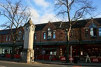
The site of Didsbury station, now a row of cafés and bars. Location Place Didsbury Local authority City of Manchester Platforms 2 Fare zone information Metrolink Zone Present status Disused Operations Original operator Cheshire Lines Committee Pre-grouping company Midland Railway Post-grouping company LMS
London Midland Region of British RailwaysHistory Opened 1 January 1880 Closed 1967 Conversion to Metrolink operation Summer 2013 

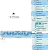
to Piccadilly and Bury 

Deansgate-Castlefield  Deansgate

Cornbrook 

to Eccles 

Trafford Bar 

to Altrincham 

Firswood 

Chorlton 

St Werburgh's Road 

to Manchester Airport 

Withington 

Burton Road 

West Didsbury 

Didsbury Village 

East Didsbury 
Disused railway stations in the United Kingdom A B C D-F G H-J K-L M-O P-R S T-V W-Z  UK Trams portal
Didsbury railway station is a former station in Didsbury, in the southern suburbs of Manchester, England, United Kingdom. The station was located on Wilmslow Road, just north of the junction with Barlow Moor Road and opposite Didsbury Library. Nothing now remains of the old station buildings, which have been demolished, but the surviving white Portland stone clock tower is a local landmark. The old trackbed remains and there are plans to re-open the line for light rail passenger services as part of the Manchester Metrolink network.[1]
Contents
History
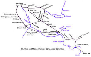
Didsbury Station opened in 1880 when the Midland Railway opened the new Manchester South District line which ran from Manchester Central Station.[2]
The Manchester South District line, and consequently Didsbury station, closed in 1967 under the Beeching Axe. For a number of years the station building was used as a hardware store, but after this closed the building fell derelict and was demolished in the early 1980s.[2] The site today is occupied by a row of pubs and cafés. All that remains of the old station is the clock tower and drinking fountain which were erected to the memory of a local doctor and campaigner for the poor, Dr. J. Milson Rhodes.
Future plans
Didsbury Village Metrolink Station is a future station proposed in Phase 3B of the Manchester Metrolink Big Bang extension plans.[3][4]
Didsbury Village will be located on the east side of School Lane, with ramps descending to the platforms and access to Olive Shapley Avenue, Didsbury. The stop will be in an existing cutting. Passengers again will be able to travel by rail to Manchester and East Didsbury for the first time since 1967, when the Midland route from Manchester Central Station was closed as part of the Beeching Axe. The new station is scheduled to open in the summer of 2013[5]
See also
- Sheffield and Midland Railway Companies' Committee
- Midland Railway
- Withington and West Didsbury railway station
References
References
- ^ Linton, Deborah (2009-05-13). "£1.4bn transport deal unveiled". Manchester Evening News. http://www.manchestereveningnews.co.uk/news/s/1115242_14bn_transport_deal_unveiled. Retrieved 2009-05-17.
- ^ a b Sussex, Gay; Helm, Peter (1988). Looking Back at Withington and Didsbury. Timperley: Willow Publishing. pp. inside front cover. ISBN 0946361258.
- ^ "Tram line extension is approved". BBC News. 2009-05-13. http://news.bbc.co.uk/1/hi/england/manchester/8047020.stm. Retrieved 2009-05-17.
- ^ "Metrolink: back on track?". BBC Manchester. 2009-05-13. http://www.bbc.co.uk/manchester/content/articles/2009/05/13/130509_metrolink_map_plan_b_feature.shtml. Retrieved 2009-05-17.
- ^ "Metrolink - South Manchester line". Transport for Greater Manchester. http://www.metrolink.co.uk/futuremetrolink/south-manchester-line.asp. Retrieved 26 June 2011.
Preceding station Manchester Metrolink
Following station Under Construction East DidsburyTerminusSouth Manchester Line West Didsburytowards Piccadilly GardensDisused railways Withington and West Didsbury
Line and station closedMidland Railway
South District RailwayHeaton Mersey
Line and station closedMetrolink
Stations City zoneAltrincham LineAltrincham · Brooklands · Cornbrook · Dane Road · Navigation Road · Old Trafford · Sale · Stretford · Timperley · Trafford Bar
Bury LineAbraham Moss · Besses o'th' Barn · Bowker Vale · Bury · Crumpsall · Heaton Park · Prestwich · Radcliffe · Whitefield · Woodlands Road
Eccles LineAnchorage · Broadway · Eccles · Exchange Quay · Harbour City · Ladywell · Langworthy · MediaCityUK · Pomona · Salford Quays · Weaste
South Manchester LineChorlton · Firswood · St Werburgh's Road


Operations OperatorsStagecoach Group · Transport for Greater ManchesterVehiclesFlexity Swift M5000 · T-68History Former operatorsTransferred linesClosed stationsAbandoned plansUnder Construction Bury LineQueens Road
East Manchester LineAshton Moss · Ashton Under Lyne · Ashton West · Audenshaw · Cemetery Road · Clayton Hall · Droylsden · Eastlands City Stadium · Edge Lane · Holt Town · New Islington · Velopark
Oldham & Rochdale LineCentral Park · Derker · Failsworth · Freehold · Hollinwood · Kingsway · Monsall · Milnrow · Newbold · Newton Heath and Moston · Newhey · Oldham Central · Oldham King Street · Oldham Mumps · Rochdale railway station · Rochdale Town Centre · Shaw & Crompton · South Chadderton · Westwood
South Manchester LinesBaguley · Barlow Moor Rd. · Benchill · Burton Road · Crossacres · Didsbury · East Didsbury · Hardy Farm · Haveley · Hough End · Manchester Airport · Martinscroft · Moor Road · Northern Moor · Peel Hall · Robinswood Road · Roundthorn · Sale Water Park · Shadowmoss · West Didsbury · Withington · Woodhouse Park · Wythenshawe Town Centre · Wythenshawe Park
Proposed Bury LineBuckley Wells
Trafford Centre LineImperial War Museum · Lostock Parkway · Manchester United · Parkway Circle · Port Salford · Salford Reds · Trafford Centre · Trafford Quays · Village
Stockport LineGorsey Bank · Heaton Mersey · Kings Reach · Stockport Interchange
Second City CrossingExchange Square
Transport for Greater Manchester · UK light rail systems Coordinates: 53°25′07″N 2°13′53″W / 53.418626°N 2.231334°W
Categories:- Didsbury
- Proposed Manchester Metrolink stations
- Disused railway stations in Manchester
- Former Midland Railway stations
- Railway stations opened in 1880
- Railway stations closed in 1967
- Manchester South District Line
- Beeching closures in England
Wikimedia Foundation. 2010.


