- Dane Road Metrolink station
-
 Dane Road
Manchester Metrolink 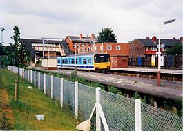
Dane Road railway station in 1988 Location Place Sale Local authority Trafford Platforms 2 Fare zone information Metrolink Zone F Operations Original operator MSJAR Post-grouping company LMS/LNER
London Midland Region of British RailwaysHistory Opened 20 July 1931 Closed 24 December 1991 Conversion to Metrolink operation 15 June 1992 Former name Dane Road (Sale)  Altrincham Line

to Piccadilly and Bury 
Deansgate-Castlefield  Deansgate
Cornbrook 

to Eccles Trafford Bar 

to East Didsbury and Manchester Airport Old Trafford Stretford Dane Road Sale Brooklands Timperley Navigation Road 
Altrincham  UK Trams portal
Dane Road station is located on Dane Road in Sale, Greater Manchester, England. The station is in Ticketing Zone F.Contents
History
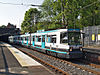
The station originally opened on 20 July 1931 by the Manchester, South Junction and Altrincham Railway (MSJAR). Referred to as Dane Road (Sale) on early tickets, timetables etc.. Operated as a four-platform station from opening until 1963. Closed as a British Rail station on 24 December 1991. Reopened as a Metrolink station on 15 June 1992.
Services
Dane Road is located on the Altrincham Line with trams towards Altrincham stopping every 6 minutes during the day, Mondays to Saturdays, every 12 minutes Monday to Saturday evenings and Sunday daytime and every 15 minutes Sunday evenings. Trams also head towards Manchester and Bury, with the Monday to Saturday daytime service running every 12 minutes each to Manchester Piccadilly or Bury, while evening and Sundays journeys run to Bury via Manchester Piccadilly.[1]
Service Pattern
- 10 tph to Altrincham
- 5 tph to Piccadilly
- 5 tph to Bury
Connecting bus routes
Dane Road station is not served by any bus service with the nearest service being Arriva North West service 99, which stop further along Dane Road and runs to Sale and to Manchester via Northenden.[2]
References
- ^ "GMPTE.com - Tram Times". GMPTE. http://www.metrolink.co.uk/tramtimes/. Retrieved 2010-09-07.
- ^ "GMPTE - Maps - Manchester South". GMPTE. http://www.gmpte.com/pdfmaps/network/2_manchester_south.pdf. Retrieved 2010-09-07.
External links
Preceding station  Manchester Metrolink
Following station towards AltrinchamAltrincham - Bury Line towards BuryAltrincham - Piccadilly Line towards Piccadilly MetrolinkStations City zoneAltrincham LineAltrincham · Brooklands · Cornbrook · Dane Road · Navigation Road · Old Trafford · Sale · Stretford · Timperley · Trafford Bar
Bury LineAbraham Moss · Besses o'th' Barn · Bowker Vale · Bury · Crumpsall · Heaton Park · Prestwich · Radcliffe · Whitefield · Woodlands Road
Eccles LineAnchorage · Broadway · Eccles · Exchange Quay · Harbour City · Ladywell · Langworthy · MediaCityUK · Pomona · Salford Quays · Weaste
South Manchester LineChorlton · Firswood · St Werburgh's Road
Operations OperatorsStagecoach Group · Transport for Greater ManchesterVehiclesFlexity Swift M5000 · T-68History Former operatorsTransferred linesClosed stationsAbandoned plansUnder Construction Bury LineQueens Road
East Manchester LineAshton Moss · Ashton Under Lyne · Ashton West · Audenshaw · Cemetery Road · Clayton Hall · Droylsden · Eastlands City Stadium · Edge Lane · Holt Town · New Islington · Velopark
Oldham & Rochdale LineCentral Park · Derker · Failsworth · Freehold · Hollinwood · Kingsway · Monsall · Milnrow · Newbold · Newton Heath and Moston · Newhey · Oldham Central · Oldham King Street · Oldham Mumps · Rochdale railway station · Rochdale Town Centre · Shaw & Crompton · South Chadderton · Westwood
South Manchester LinesBaguley · Barlow Moor Rd. · Benchill · Burton Road · Crossacres · Didsbury · East Didsbury · Hardy Farm · Haveley · Hough End · Manchester Airport · Martinscroft · Moor Road · Northern Moor · Peel Hall · Robinswood Road · Roundthorn · Sale Water Park · Shadowmoss · West Didsbury · Withington · Woodhouse Park · Wythenshawe Town Centre · Wythenshawe Park
Proposed Bury LineBuckley Wells
Trafford Centre LineImperial War Museum · Lostock Parkway · Manchester United · Parkway Circle · Port Salford · Salford Reds · Trafford Centre · Trafford Quays · Village
Stockport LineGorsey Bank · Heaton Mersey · Kings Reach · Stockport Interchange
Second City CrossingExchange Square
Transport for Greater Manchester · UK light rail systems Coordinates: 53°25′49″N 2°18′41″W / 53.4304°N 2.31125°W

This UK Tram-related article is a stub. You can help Wikipedia by expanding it.


