- Trafford Bar Metrolink station
-
"Old Trafford railway station" redirects here. For the station known since 1992 as Old Trafford, see Old Trafford Metrolink station.
 Trafford Bar
Manchester Metrolink 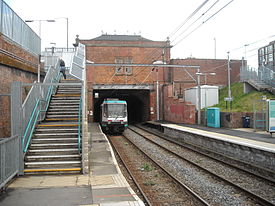
Trafford Bar Metrolink station in 2009 Location Place Old Trafford Local authority Trafford Platforms 2 Fare zone information Metrolink Zone E Operations Original operator MSJAR Post-grouping company LMS/LNER
London Midland Region of British RailwaysHistory Opened 20 July 1849 Closed 24 December 1991 Conversion to Metrolink operation 15 June 1992 Former name Old Trafford Renamed 1992  Altrincham Line

to Piccadilly and Bury 
Deansgate-Castlefield  Deansgate
Cornbrook 

to Eccles Trafford Bar 

to East Didsbury and Manchester Airport Old Trafford Stretford Dane Road Sale Brooklands Timperley Navigation Road 
Altrincham  UK Trams portal
Trafford Bar Metrolink Station serves the areas of Old Trafford and Whalley Range in Greater Manchester and lies at the junction of Talbot Road and Seymour Grove, it is also one of several stops used for Old Trafford Stadium and thus one of the busier on the line. Once the current construction of the South Manchester lines is complete it will be a major interchange between the two lines. The station is currently in Ticketing Zone E.
Contents
History
The station was originally called Old Trafford and was opened on 20 July 1849 by the Manchester, South Junction and Altrincham Railway (MSJ&AR). Closed as a British Rail station on 24 December 1991. The "Old Trafford" name was transferred to the former Warwick Road Station, to avoid confusion for passengers travelling to Old Trafford Football Ground, and Old Trafford Cricket Ground. It was renamed Trafford Bar when it reopened as a Metrolink station on 15 June 1992.
Services
Trafford Bar is located on the Altrincham Line with trams towards Altrincham stopping every 6 minutes during the day, Mondays to Saturdays, every 12 minutes Monday to Saturday evenings and Sunday daytime and every 15 minutes Sunday evenings. Trams also head towards Manchester and Bury, with the Monday to Saturday daytime service running every 12 minutes each to Manchester Piccadilly or Bury, while evening and Sundays journeys run to Bury via Manchester Piccadilly.
Trafford Bar is also located on the South Manchester Line with trams towards Victoria and St Werburgh's Road running every 12 minutes Monday-Saturdays and Sunday daytime and every 15 minutes Sunday early mornings and evenings.[1] Service will increase from 12 minutes to 6 minutes once the line to Central Park, Oldham Mumps and Rochdale opens. Services will extend from St Werburgh's Road to East Didsbury in 2013 and additional services will run between the city centre and Manchester Airport in 2016.
Service Pattern
- 10 tph to Altrincham
- 5 tph to Piccadilly
- 5 tph to Bury
- 5 tph to Victoria
- 5 tph to St. Werburgh's Road
- 5 tph to Manchester Airport
Connecting bus routes
Trafford Bar station is served nearby by First Manchester service 53, which runs to Pendleton via Salford Quays and to Cheetham Hill via the universities, Rusholme, Gorton and Harpurhey, Stagecoach Manchester/Arriva North West service 84, which runs to Reddish via Chorlton, West Didsbury and East Didsbury, Stagecoach services 250 which runs to Trafford Centre, Stagecoach service 255 to Partington via Stretford and Urmston, Stagecoach/JPT service 256 to Flixton via Stretford and Arriva services 263/264, which run to Altrincham via Stretford and Sale. Services 84, 250, 255, 256 and 263 all run to Manchester Piccadilly Gardens, while the 264 runs to Shudehill Interchange.[2][3]
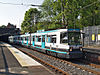
 Trafford Bar in 1983, displaying its former Old Trafford name and British Rail branding
References
- ^ "Metrolink - Tram Times". Transport for Greater Manchester. http://www.metrolink.co.uk/tramtimes/. Retrieved 6 July 2011.
- ^ "Transport for Greater Manchester - Journey Planning - Network Maps". Transport for Greater Manchester. http://www.tfgm.com/journey_planning/network_maps.cfm. Retrieved 6 July 2011.
- ^ "Transport for Greater Manchester - Journey Planning - Bus Time Leaflet Library". Transport for Greater Manchester. http://www.tfgm.com/journey_planning/bus_times_leaflet_library.cfm. Retrieved 6 July 2011.
External links
Preceding station  Manchester Metrolink
Following station towards AltrinchamAltrincham - Bury Line towards BuryAltrincham - Piccadilly Line towards PiccadillyFirswoodtowards St Werburgh's RoadSt Werburgh's Road - Victoria Line towards VictoriaUnder Construction Firswoodtowards East DidsburySouth Manchester Line towards VictoriaDisused railways Cornbrook
1856–65
Line and station closedManchester, South Junction
and Altrincham RailwayWarwick Road for Old Trafford
Line and station openDeansgate
1849–56, 1865–1991
Line closed, station open MetrolinkStations City zoneAltrincham LineAltrincham · Brooklands · Cornbrook · Dane Road · Navigation Road · Old Trafford · Sale · Stretford · Timperley · Trafford Bar
Bury LineAbraham Moss · Besses o'th' Barn · Bowker Vale · Bury · Crumpsall · Heaton Park · Prestwich · Radcliffe · Whitefield · Woodlands Road
Eccles LineAnchorage · Broadway · Eccles · Exchange Quay · Harbour City · Ladywell · Langworthy · MediaCityUK · Pomona · Salford Quays · Weaste
South Manchester LineChorlton · Firswood · St Werburgh's Road
Operations OperatorsVehiclesHistory Former operatorsTransferred linesClosed stationsAbandoned plansUnder Construction Bury LineQueens Road
East Manchester LineAshton Moss · Ashton Under Lyne · Ashton West · Audenshaw · Cemetery Road · Clayton Hall · Droylsden · Eastlands City Stadium · Edge Lane · Holt Town · New Islington · Velopark
Oldham & Rochdale LineCentral Park · Derker · Failsworth · Freehold · Hollinwood · Kingsway · Monsall · Milnrow · Newbold · Newton Heath and Moston · Newhey · Oldham Central · Oldham King Street · Oldham Mumps · Rochdale railway station · Rochdale Town Centre · Shaw & Crompton · South Chadderton · Westwood
South Manchester LinesBaguley · Barlow Moor Rd. · Benchill · Burton Road · Crossacres · Didsbury · East Didsbury · Hardy Farm · Haveley · Hough End · Manchester Airport · Martinscroft · Moor Road · Northern Moor · Peel Hall · Robinswood Road · Roundthorn · Sale Water Park · Shadowmoss · West Didsbury · Withington · Woodhouse Park · Wythenshawe Town Centre · Wythenshawe Park
Proposed Bury LineBuckley Wells
Trafford Centre LineImperial War Museum · Lostock Parkway · Manchester United · Parkway Circle · Port Salford · Salford Reds · Trafford Centre · Trafford Quays · Village
Stockport LineGorsey Bank · Heaton Mersey · Kings Reach · Stockport Interchange
Second City CrossingExchange Square
Categories:- Railway stations in Trafford
- Former Manchester, South Junction and Altrincham Railway stations
- Manchester Metrolink Bury-Altrincham line stations
- Railway stations opened in 1849
- Railway stations closed in 1991
- Railway stations opened in 1992


Wikimedia Foundation. 2010.