- Deansgate-Castlefield Metrolink station
-
Deansgate-Castlefield
Manchester Metrolink 
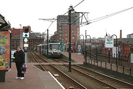
Metrolink tram at Deansgate-Castlefield in 2007 (when station was known as G-Mex) Location Place Castlefield, Manchester City Centre Local authority Manchester Platforms 2 Fare zone information Metrolink Zone D (City) History Opened 1992-04-27
As terminus
1992-06-15
For through servicesto Bury 

to Rochdale 


Victoria 


Second City Crossing 


Shudehill 


High Street Exchange Square 


Market Street 


Mosley Street 


Piccadilly Gardens 


Piccadilly 
St Peter's Square 


to Ashton-under-Lyne D'gate-Castlefield 


(  Deansgate)


Cornbrook to MediaCityUK and Eccles 


Trafford Bar 


to East Didsbury and to Altrincham 

Manchester Airport  UK Trams portal
Deansgate-Castlefield Metrolink station (formerly named G-Mex Metrolink station) is a station on the Metrolink light rail system which operates in Greater Manchester, England. It is located in the Castlefield area of Manchester city centre, immediately next to the former Manchester Central station, which is now the Manchester Central Conference Centre.
The Metrolink station used to take its name from the previous identity of the conference centre, which re-opened after its refurbishment in 1986 as the Greater Manchester Exhibition Centre (G-Mex).[1] As the centre has since been rebranded with the name of the former railway terminus, the Metrolink station's new name reflects the actual location of the stop.[2]
Deansgate-Castlefield Metrolink station serves as an interchange station with National Rail services from Deansgate railway station - the two stations are linked by a footbridge. There is another footbridge linking the Metrolink station to The Great Northern Warehouse, and staircase exits to Collier Street (Mamucium Roman Fort) and to Deansgate Lock on Whitworth Street West.
Deansgate-Castlefield station is the point where the Manchester Metrolink changes between 'tram-mode' for street-running through the city centre and 'train mode' for running on the former British Rail lines.
Contents
History
Manchester Central railway station, one of the city's main railway terminals, was built between 1875–80 by the Cheshire Lines Committee railway company and served as the terminus for Midland Railway express services to London. The station was notable as an engineering feat - its huge wrought-iron single-span arched roof, spanning 210 feet (64 m), 550 feet (168 m) long and 90 feet (27 m) high is claimed to be the widest unsupported iron arch in Britain after London St. Pancras.[1]
Following the Beeching cuts, the station was deemed surplus to requirements and closed to passengers on 5 May 1969. The listed building survived as a local landmark, and after serving as a car park, the old station was refrubished as re-opened as an exhibition and conference centre.
With the opening of the Metrolink system, rail services were able to operate once more from south Manchester to Central Station; however, instead of trains running into the Central Station arch, light rail vehicles now run alongside the south-eastern side of the former train shed, down a ramp which runs parallel to Lower Mosley Street, before reaching street level where they operate as trams and head towards St Peter's Square. The viaduct beneath the station, overlooking the Rochdale Canal, has since been refurbished and converted for leisure purposes - bars, clubs.
Central Station featured in early proposals to build a light rail system in Manchester; the station featured in 1984 publicity with an interchange to Deansgate;[3] by 1987, the station had acquired the name 'G-Mex' and the system was now known as 'Metrolink' .[4]
In August 2010 Metrolink announced it would be changing the name of the stop from 'G-Mex' to 'Deansgate-Castlefield'. On 2 September 2010, signs at the stop were changed to 'Deansgate-Castlefield'; a couple of days later temporary vinyl GMEX stickers were placed on top which were removed ON 20 September 2010 when the name change was made.
Service Pattern
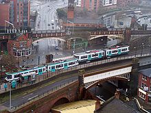
 Aerial shot of two trams passing at Deansgate-Castlefield, with the line through Deansgate railway station in the background.
- 10 tph to Altrincham
- 15 tph to Piccadilly
- 5 tph to Bury
- 5 tph to Victoria
- 5 tph to St Werburgh's Road
- 5 tph MediaCityUk
Future
It had been thought for some time that the second city crossing (2CC) expansion would require a third platform at the stop. However, 2011 proposals[5] show St Peter's Square as a major 4-platform interchange, putting the third platform at Deansgate-Castlefield into doubt. Manchester City Council was also known to be working on a proposal[6] to better integrate the tram stop and Deansgate railway station as well as creating a key interchange, which remain unaffected by the 2011 2CC proposals. At MIPIM 2010 proposals were unveiled [7] for a redevelopment of the area behind the conference centre. The ambitious scheme creates a pedestrian skypark walkway along the side of the conference centre to ground level creating better pedestrian access to both the conference centre and the city centre itself; a new bridge to link to Deansgate station, replacing the tired and unappealing original; and the creation of a new train shed on the viaduct for the tram stop's three platforms including access to ground level. The scheme linked to office development of the surrounding area could be operational by 2014 [8] and create a principal southern rail and tram interchange for the city centre similar to Victoria and Piccadilly. The plan is continuing but remains dependent on the proposed local redevelopment proceeding.
References
- ^ a b "Greater Manchester Exhibition Centre (G-Mex)". Manchester Evening News. July 18, 2003. http://www.manchestereveningnews.co.uk/entertainment/days_out/s/63/63208_greater_manchester_exhibition_centre_gmex.html. Retrieved 2009-07-07.[dead link]
- ^ http://www.gmpte.com/2009_news.cfm?news_id=9004616 . Name change for GMEX Metrolink stop.
- ^ Greater Manchester Passenger Transport Executive (1984), Light Rapid Transit in Greater Manchester, GMPTE - publicity brochure
- ^ Metrolink Community Liaison (1987). "Metrolink - Light Rail in Greater Manchester". publicity brochure (Greater Manchester Passenger Transport Authority and Executive).
- ^ http://www.tfgm.com/Metrolink2cc/second_city_crossing_stops.cfm?submenuheader=0
- ^ http://www.manchester.gov.uk/download/11871/civic_quarter-manchester_central_regeneration_framework
- ^ http://www.crainsmanchesterbusiness.co.uk/article/20100319/FREE/100319816/-1/breaking
- ^ http://www.youtube.com/watch?v=aaDLGxTTxno&feature=channel
External links
- Tram times and station information for Deansgate-Castlefield Metrolink station from Manchester Metrolink
- Manchester Central proposal (from roughly 5:15)
Coordinates: 53°28′29″N 2°15′01″W / 53.4747°N 2.2503°W
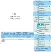
Manchester Lines - City Centre and North, (Past, Present and Future) LegendTo Bury 


To Rochdale Moston 


To Oldham Bowker Vale 


Newton Heath 


Newton Heath and Moston 


Crumpsall 


Central Park 


To Tameside Abraham Moss;Monsall 


Clayton Bridge Woodlands Road 


Park Queens Road 


To Tameside Miles Platting 


Edge Lane 


Clayton Oldham Road 


Sportcity-Velodrome Manchester Victoria 


Holt Town/Sportcity-Stadium Exchange 


To Salford 


New Islington 


Ardwick Exchange Square/Shudehill 


Ashburys High Street; Manchester Piccadilly 


Mayfield;To South Manchester Market Street; Piccadilly Gardens 


To Belle Vue;Gorton Moseley Street;Oxford Road 


To Hyde Road St Peter's Square 


To Tameside Manchester Central/Deansgate-Castlefield 


Deansgate Liverpool Road 


To Salford;Cornbrook 


Cornbrook 


Pomona 


To Eccles 


Trafford Bar To Trafford 


Firswood To Trafford;To Altrincham 


To Chorlton Preceding station Manchester Metrolink
Following station towards AltrinchamAltrincham - Bury Line towards BuryAltrincham - Piccadilly Line towards Piccadillytowards EcclesEccles - Piccadilly Line towards St Werburgh's RoadSt Werburgh's Road - Victoria Line towards VictoriaUnder Construction towards East DidsburySouth Manchester Line towards VictoriaMetrolink
Stations City zoneDeansgate-Castlefield · Market Street · Mosley Street · Piccadilly · Piccadilly Gardens · Shudehill · St Peter's Square · Victoria
Altrincham LineAltrincham · Brooklands · Cornbrook · Dane Road · Navigation Road · Old Trafford · Sale · Stretford · Timperley · Trafford Bar
Bury LineAbraham Moss · Besses o'th' Barn · Bowker Vale · Bury · Crumpsall · Heaton Park · Prestwich · Radcliffe · Whitefield · Woodlands Road
Eccles LineAnchorage · Broadway · Eccles · Exchange Quay · Harbour City · Ladywell · Langworthy · MediaCityUK · Pomona · Salford Quays · Weaste
South Manchester LineChorlton · Firswood · St Werburgh's Road


Operations OperatorsStagecoach Group · Transport for Greater ManchesterVehiclesFlexity Swift M5000 · T-68History Former operatorsTransferred linesClosed stationsAbandoned plansUnder Construction Bury LineQueens Road
East Manchester LineAshton Moss · Ashton Under Lyne · Ashton West · Audenshaw · Cemetery Road · Clayton Hall · Droylsden · Eastlands City Stadium · Edge Lane · Holt Town · New Islington · Velopark
Oldham & Rochdale LineCentral Park · Derker · Failsworth · Freehold · Hollinwood · Kingsway · Monsall · Milnrow · Newbold · Newton Heath and Moston · Newhey · Oldham Central · Oldham King Street · Oldham Mumps · Rochdale railway station · Rochdale Town Centre · Shaw & Crompton · South Chadderton · Westwood
South Manchester LinesBaguley · Barlow Moor Rd. · Benchill · Burton Road · Crossacres · Didsbury · East Didsbury · Hardy Farm · Haveley · Hough End · Manchester Airport · Martinscroft · Moor Road · Northern Moor · Peel Hall · Robinswood Road · Roundthorn · Sale Water Park · Shadowmoss · West Didsbury · Withington · Woodhouse Park · Wythenshawe Town Centre · Wythenshawe Park
Proposed Bury LineBuckley Wells
Trafford Centre LineImperial War Museum · Lostock Parkway · Manchester United · Parkway Circle · Port Salford · Salford Reds · Trafford Centre · Trafford Quays · Village
Stockport LineGorsey Bank · Heaton Mersey · Kings Reach · Stockport Interchange
Second City CrossingExchange Square
Transport for Greater Manchester · UK light rail systems Categories:- Railway stations in Manchester
- Manchester Metrolink Eccles line stations
Wikimedia Foundation. 2010.
