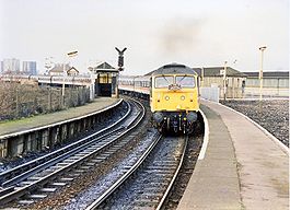
- Miles Platting railway station
-
Miles Platting 
Miles Platting railway station in 1989 Location Place Miles Platting Area City of Manchester Grid reference SD860000 Operations Original company Manchester and Leeds Railway Pre-grouping Lancashire and Yorkshire Railway Post-grouping London, Midland and Scottish Railway Platforms 4 History 1 January 1844 Opened 27 May 1995 Closed Disused railway stations in the United Kingdom Closed railway stations in Britain
A B C D–F G H–J K–L M–O P–R S T–V W–ZMiles Platting railway station served the district of Miles Platting in Manchester from 1844 until closure on 27 May 1995.[1] The station was opened on 1 January 1844 by the Manchester and Leeds Railway;[2] after amalgamating with other railways, this became the Lancashire and Yorkshire Railway in 1847.[3] The station was situated at the junction of the lines to Stalybridge (opened 1846[4]) and Rochdale (opened 1839[5]), and had platforms on both routes. Little trace remains of the station today, as the platforms were removed and the buildings demolished after closure. However, a length of platform awning has been re-erected at Ramsbottom station on the preserved East Lancs Railway.
References
- ^ "List of dates from 1 January 1985 to 20 January 2006 of last passenger trains at closed BR (or Network Rail stations since privatisation)". Department for Transport Website: Freedom of Information Act responses, February 2006. Department for Transport. 2006. http://www.dft.gov.uk/foi/responses/2006/feb/closuredatesformerbrstations/listofclosuredatestopassenge2682. Retrieved 2008-08-09.[dead link]
- ^ Butt 1995, p. 159
- ^ Marshall 1969, p. 65
- ^ Marshall 1969, p. 63
- ^ Marshall 1969, p. 47
- Bairstow, Martin. The Manchester and Leeds Railway.
- Butt, R.V.J. (1995). The Directory of Railway Stations. Yeovil: Patrick Stephens Ltd. ISBN 1 85260 508 1. R508.
- Marshall, John (1969). The Lancashire & Yorkshire Railway, volume 1. Newton Abbot: David & Charles. ISBN 0 7153 4352 1.
- Wells, Jeffrey. The Oldham Loop. ISBN 1-870119-76-2.
Preceding station Historical railways Following station Manchester Victoria
Line and station openL&YR
Caldervale LineNewton Heath
Line open, station closedL&YR
Huddersfield LinePark
Line open, station closedDisused railways Manchester Victoria
Line and station openL&YR
Oldham Loop LineDean Lane
Line and station closedManchester Lines - City Centre and North, (Past, Present and Future) LegendTo Bury 


To Rochdale Moston 


To Oldham Bowker Vale 


Newton Heath 


Newton Heath and Moston 


Crumpsall 


Central Park 


To Tameside Abraham Moss;Monsall 


Clayton Bridge Woodlands Road 


Park Queens Road 


To Tameside Miles Platting 


Edge Lane 


Clayton Oldham Road 


Sportcity-Velodrome Manchester Victoria 


Holt Town/Sportcity-Stadium Exchange 


To Salford 


New Islington 


Ardwick Exchange Square/Shudehill 


Ashburys High Street; Manchester Piccadilly 


Mayfield;To South Manchester Market Street; Piccadilly Gardens 


To Belle Vue;Gorton Moseley Street;Oxford Road 


To Hyde Road St Peter's Square 


To Tameside Manchester Central/Deansgate-Castlefield 


Deansgate Liverpool Road 


To Salford;Cornbrook 


Cornbrook 


Pomona 


To Eccles 


Trafford Bar To Trafford 


Firswood To Trafford;To Altrincham 


To Chorlton Categories:- Disused railway stations in Manchester
- Former Lancashire and Yorkshire Railway stations
- Railway stations opened in 1844
- Railway stations closed in 1995
- Greater Manchester railway station stubs
Wikimedia Foundation. 2010.
