- Crumpsall Metrolink station
-
 Crumpsall
Manchester Metrolink 
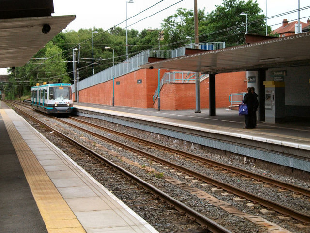
Crumpsall station in 2010 Location Place Crumpsall Local authority Manchester Platforms 2 Fare zone information Metrolink Zone C Operations Original operator Lancashire & Yorkshire Railway Post-grouping company LMS
British RailConversion to Metrolink operation 1992-04-06  Bury Line

Bury  Bury Bolton Street
Buckley Wells 
Radcliffe Whitefield Besses o'th' Barn Prestwich Heaton Park Bowker Vale Crumpsall Abraham Moss Woodlands Road Queens Road 

to Rochdale Town Centre 
Manchester Victoria 

to Piccadilly Gardens  UK Trams portal
Crumpsall Metrolink station is a Manchester Metrolink station on the former Manchester Victoria to Bury railway line and is located on the corner of Crumpsall Lane and Station Road. The station forms part of Ticketing Zone C and is the stop for North Manchester General Hospital, which can be reached by connecting bus services. The station installed Falco cycle lockers in July 2011.
Contents
Services
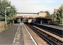 Crumpsall railway station in 1988
Crumpsall is located on the Bury Line with trams towards Bury stopping every 6 minutes during the day, Mondays to Saturdays, every 12 minutes Monday to Saturday evenings and Sunday daytime and every 15 minutes Sunday evenings. Trams also head towards Manchester and Altrincham, with the Monday to Saturday daytime service running every 12 minutes each to Manchester Piccadilly or Altrincham, while evening and Sundays journeys run to Altrincham via Manchester Piccadilly.[1]
Connecting Bus Services
Crumpsall is served by First Manchester services 88 and 149 to Manchester via North Manchester General Hospital and services 89 and 149 from Manchester, with the 89 running a circular service back to Manchester via Higher Blackley, while service 149 runs to Oldham via Moston and Hollinwood. Bluebird service 154 also stops at Crumpsall running to the hospital and Cheetham Hill before continuing to Bury via Prestwich.[2]
References
- ^ "GMPTE.com - Tram Times". GMPTE. http://www.metrolink.co.uk/tramtimes/. Retrieved 2010-09-07.
- ^ "GMPTE - Maps - Manchester North". GMPTE. http://www.gmpte.com/pdfmaps/network/1_manchester_north.pdf. Retrieved 2010-09-07.
External links
Preceding station  Manchester Metrolink
Following station Abraham Mosstowards AltrinchamAltrincham - Bury Line towards BuryAbraham Mosstowards PiccadillyBury - Piccadilly Line Manchester Lines - City Centre and North, (Past, Present and Future) LegendTo Bury 

To Rochdale Moston 


To Oldham Bowker Vale 


Newton Heath 


Newton Heath and Moston 

Crumpsall 


Central Park 

To Tameside Abraham Moss;Monsall Clayton Bridge Woodlands Road Park Queens Road 


To Tameside Miles Platting Edge Lane 


Clayton Oldham Road 
Sportcity-Velodrome Manchester Victoria 


Holt Town/Sportcity-Stadium Exchange 

To Salford 
New Islington 


Ardwick Exchange Square/Shudehill 

Ashburys High Street; Manchester Piccadilly 


Mayfield;To South Manchester Market Street; Piccadilly Gardens 


To Belle Vue;Gorton Moseley Street;Oxford Road 


To Hyde Road St Peter's Square To Tameside Manchester Central/Deansgate-Castlefield 

Deansgate Liverpool Road 


To Salford;Cornbrook Cornbrook 


Pomona To Eccles 

Trafford Bar To Trafford 


Firswood To Trafford;To Altrincham To Chorlton MetrolinkStations City zoneAltrincham LineAltrincham · Brooklands · Cornbrook · Dane Road · Navigation Road · Old Trafford · Sale · Stretford · Timperley · Trafford Bar
Bury LineAbraham Moss · Besses o'th' Barn · Bowker Vale · Bury · Crumpsall · Heaton Park · Prestwich · Radcliffe · Whitefield · Woodlands Road
Eccles LineAnchorage · Broadway · Eccles · Exchange Quay · Harbour City · Ladywell · Langworthy · MediaCityUK · Pomona · Salford Quays · Weaste
South Manchester LineChorlton · Firswood · St Werburgh's Road
Operations OperatorsStagecoach Group · Transport for Greater ManchesterVehiclesFlexity Swift M5000 · T-68History Former operatorsTransferred linesClosed stationsAbandoned plansUnder Construction Bury LineQueens Road
East Manchester LineAshton Moss · Ashton Under Lyne · Ashton West · Audenshaw · Cemetery Road · Clayton Hall · Droylsden · Eastlands City Stadium · Edge Lane · Holt Town · New Islington · Velopark
Oldham & Rochdale LineCentral Park · Derker · Failsworth · Freehold · Hollinwood · Kingsway · Monsall · Milnrow · Newbold · Newton Heath and Moston · Newhey · Oldham Central · Oldham King Street · Oldham Mumps · Rochdale railway station · Rochdale Town Centre · Shaw & Crompton · South Chadderton · Westwood
South Manchester LinesBaguley · Barlow Moor Rd. · Benchill · Burton Road · Crossacres · Didsbury · East Didsbury · Hardy Farm · Haveley · Hough End · Manchester Airport · Martinscroft · Moor Road · Northern Moor · Peel Hall · Robinswood Road · Roundthorn · Sale Water Park · Shadowmoss · West Didsbury · Withington · Woodhouse Park · Wythenshawe Town Centre · Wythenshawe Park
Proposed Bury LineBuckley Wells
Trafford Centre LineImperial War Museum · Lostock Parkway · Manchester United · Parkway Circle · Port Salford · Salford Reds · Trafford Centre · Trafford Quays · Village
Stockport LineGorsey Bank · Heaton Mersey · Kings Reach · Stockport Interchange
Second City CrossingExchange Square
Transport for Greater Manchester · UK light rail systems Coordinates: 53°31′03″N 2°14′27″W / 53.5174°N 2.24095°W

This UK Tram-related article is a stub. You can help Wikipedia by expanding it.