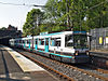
- Clayton Hall Metrolink station
-
For the rapid transit station located in St. Louis, Missouri, see Clayton (St. Louis MetroLink).
 Clayton Hall
Manchester Metrolink Location Place Clayton, Greater Manchester Local authority City of Manchester Platforms 2 Fare zone information Metrolink Zone Present status Proposed station History Opening Summer 2012  East Manchester Line
to Piccadilly Gardens 

Manchester Piccadilly 

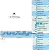
New Islington Holt Town Etihad Campus Velopark Clayton Hall Edge Lane Cemetery Road Droylsden Audenshaw Ashton Moss Ashton West 
Ashton-under-Lyne  UK Trams portal
Clayton Hall Metrolink Station is a future station proposed in Phase 3a of the Manchester Metrolink. The station was previously to be simply titled Clayton and is scheduled to open in the summer of 2012[1] and will be located on the East Manchester line on Clayton Hall Road near to the junction of Ashton New Road[2].Services
Trams are scheduled along the East Manchester line westbound towards Manchester Piccadilly station before continuing through the city centre towards other destinations, whilst eastbound trams will head towards Ashton-under-Lyne. Trams will run every 12 minutes Monday-Saturday daytime, increasing to every 6 minutes at peak times. On Sundays and Bank Holidays, there will be a 15 minute service[1].
Preceding station  Manchester Metrolink
Following station Under Construction towards Piccadilly GardensEast Manchester Line towards Ashton-under-LyneReferences
- ^ a b "Metrolink - East Manchester line". Transport for Greater Manchester. http://www.metrolink.co.uk/futuremetrolink/east-manchester-line.asp. Retrieved 26 June 2011.
- ^ "Metrolink - Clayton Hall station". Transport for Greater Manchester. http://www.metrolink.co.uk/pdf/future_metrolink/east-manchester-line/clayton.pdf. Retrieved 26 June 2011.
External links
Manchester Lines - City Centre and North, (Past, Present and Future) LegendTo Bury 

To Rochdale Moston 


To Oldham Bowker Vale 


Newton Heath 


Newton Heath and Moston 

Crumpsall 


Central Park 

To Tameside Abraham Moss;Monsall Clayton Bridge Woodlands Road Park Queens Road 


To Tameside Miles Platting 
Edge Lane 


Clayton Oldham Road 
Sportcity-Velodrome Manchester Victoria 


Holt Town/Sportcity-Stadium Exchange 

To Salford 
New Islington 


Ardwick Exchange Square/Shudehill 

Ashburys High Street; Manchester Piccadilly 


Mayfield;To South Manchester Market Street; Piccadilly Gardens 


To Belle Vue;Gorton Moseley Street;Oxford Road 


To Hyde Road St Peter's Square To Tameside Manchester Central/Deansgate-Castlefield 

Deansgate Liverpool Road 


To Salford;Cornbrook Cornbrook 


Pomona To Eccles 

Trafford Bar To Trafford 


Firswood To Trafford;To Altrincham 
To Chorlton Coordinates: 53°28′58″N 2°10′58″W / 53.4828°N 2.1829°W
MetrolinkStations City zoneAltrincham LineAltrincham · Brooklands · Cornbrook · Dane Road · Navigation Road · Old Trafford · Sale · Stretford · Timperley · Trafford Bar
Bury LineAbraham Moss · Besses o'th' Barn · Bowker Vale · Bury · Crumpsall · Heaton Park · Prestwich · Radcliffe · Whitefield · Woodlands Road
Eccles LineAnchorage · Broadway · Eccles · Exchange Quay · Harbour City · Ladywell · Langworthy · MediaCityUK · Pomona · Salford Quays · Weaste
South Manchester LineChorlton · Firswood · St Werburgh's Road
Operations OperatorsStagecoach Group · Transport for Greater ManchesterVehiclesFlexity Swift M5000 · T-68History Former operatorsTransferred linesClosed stationsAbandoned plansUnder Construction Bury LineQueens Road
East Manchester LineAshton Moss · Ashton Under Lyne · Ashton West · Audenshaw · Cemetery Road · Clayton Hall · Droylsden · Eastlands City Stadium · Edge Lane · Holt Town · New Islington · Velopark
Oldham & Rochdale LineCentral Park · Derker · Failsworth · Freehold · Hollinwood · Kingsway · Monsall · Milnrow · Newbold · Newton Heath and Moston · Newhey · Oldham Central · Oldham King Street · Oldham Mumps · Rochdale railway station · Rochdale Town Centre · Shaw & Crompton · South Chadderton · Westwood
South Manchester LinesBaguley · Barlow Moor Rd. · Benchill · Burton Road · Crossacres · Didsbury · East Didsbury · Hardy Farm · Haveley · Hough End · Manchester Airport · Martinscroft · Moor Road · Northern Moor · Peel Hall · Robinswood Road · Roundthorn · Sale Water Park · Shadowmoss · West Didsbury · Withington · Woodhouse Park · Wythenshawe Town Centre · Wythenshawe Park
Proposed Bury LineBuckley Wells
Trafford Centre LineImperial War Museum · Lostock Parkway · Manchester United · Parkway Circle · Port Salford · Salford Reds · Trafford Centre · Trafford Quays · Village
Stockport LineGorsey Bank · Heaton Mersey · Kings Reach · Stockport Interchange
Second City CrossingExchange Square
Transport for Greater Manchester · UK light rail systems Categories:- Proposed Manchester Metrolink stations
- Greater Manchester railway station stubs


Wikimedia Foundation. 2010.