- Oldham Clegg Street railway station
-
Oldham Clegg Street Location Place Oldham Area Oldham Coordinates 53°32′16″N 2°06′41″W / 53.53771°N 2.11131°WCoordinates: 53°32′16″N 2°06′41″W / 53.53771°N 2.11131°W Grid reference SD928046 Operations Original company Oldham, Ashton and Guide Bridge Railway Pre-grouping OAGB Post-grouping OAGB History 26 August 1861 Opened 4 May 1959 Closed Disused railway stations in the United Kingdom Closed railway stations in Britain
A B C D–F G H–J K–L M–O P–R S T–V W–ZOldham Clegg Street railway station was one of five stations that served the town of Oldham in northwest England.
Contents
History
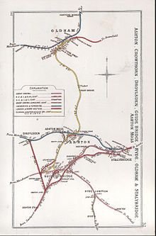
The station was the northernmost passenger station on the Oldham, Ashton and Guide Bridge Railway;[1][2] it opened on 26 August 1861.[3] To the south of the station was a tunnel, known as Oldham Tunnel; it was 59 yards (54 m) in length.[4]
The station was reconstructed in the late 1890s, the works being finished in 1900.[4] The station closed on 4 May 1959.[3]
Routes
Oldham Lines - Past, Present and Future Legend

To Huddersfield Delph 

Diggle Measurements 


Dobcross 

Saddleworth 

Moorgate Halt 
Uppermill Greenfield 
Friezland To Rochdale 


To Tameside Shaw and Crompton 
Royton 


To Tameside Grasscroft Royton Junction Grotton and Springhead Derker Lees Oldham Mumps Oldham Glodwick Road 


Oldham Central Oldham Central; Oldham Clegg Street King Street To Ashton Westwood Oldham Werneth 

Chadderton 


MJOB To Middleton and Rochdale 

Freehold Middleton Junction South Chadderton To Manchester 
Hollinwood Failsworth 
To Manchester Preceding station Disused railways Following station Oldham Mumps L&YR
L&NW
GC
Oldham, Ashton and Guide Bridge RailwayPark Bridge Oldham Glodwick Road Notes
References
- Bairstow, Martin. The Manchester and Leeds Railway.
- Butt, R.V.J. (1995). The Directory of Railway Stations. Yeovil: Patrick Stephens Ltd. ISBN 1 85260 508 1. R508.
- Ian Allan (1976). British Railways Pre-Grouping Atlas and Gazetteer (Map). 1" = 8 miles. Cartography by W. Philip Conolly (5th ed.). ISBN 0 7110 0320 3.
- Dow, George (1959). Great Central, Volume One: The Progenitors, 1813-1863. Shepperton: Ian Allan. ISBN 0 7110 1468 X.
- Dow, George (1962). Great Central, Volume Two: Dominion of Watkin, 1864-1899. Shepperton: Ian Allan. ISBN 0 7110 1469 8.
- Hooper, John. An Illustrated History of Oldham's Railways. ISBN 1-871608-19-8.
- Wells, Jeffrey. The Oldham Loop. ISBN 1-870119-76-2.
Categories:- Disused railway stations in Oldham
- Former Oldham, Ashton and Guide Bridge Railway stations
- Railway stations closed in 1959
- Greater Manchester railway station stubs

Wikimedia Foundation. 2010.