- North Kesteven
-
North Kesteven District — District — 
Coat of arms of North KestevenShown within the ceremonial county of Lincolnshire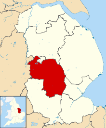
Sovereign state United Kingdom Constituent country England Region East Midlands Administrative county Lincolnshire Founded Admin. HQ Sleaford Government - Type North Kesteven District Council - Leadership: Leader & Cabinet - Executive: Conservative - MPs: Stephen Phillips QC,
Karl McCartneyArea - Total 356.2 sq mi (922.5 km2) Area rank 31st Population (2010 est.) - Total 106,400 - Rank Ranked 213th - Density 298.7/sq mi (115.3/km2) Time zone Greenwich Mean Time (UTC+0) - Summer (DST) British Summer Time (UTC+1) Postcode ISO 3166-2 ONS code 32UE OS grid reference NUTS 3 Ethnicity 98.9% White Website n-kesteven.gov.uk North Kesteven is a local government district in the East Midlands. Just over 100 miles (160 km) north of London, it is east of Nottingham and south of Lincoln. North Kesteven is one of seven districts in Lincolnshire, England and is in the centre of the County. Its council, North Kesteven District Council, is based in Sleaford in the former offices of Kesteven County Council.
Contents
History
It was originally planned to have the council offices in Bracebridge Hall on Newark Road in Lincoln, then the base of North Kesteven Rural District. In November 1973, a decision was taken to base it in The Hoplands in Sleaford, the base of East Kesteven Rural District. In January 1974 it was realised that this building was far too small for the size needed, and the 81 rooms of Kesteven County Council's headquarters on East Road in Sleaford would suit the new council instead. The Hoplands has now been demolished for housing.
The district was formed on 1 April 1974, under the Local Government Act 1972. It was a merger of the previous urban district of Sleaford, along with East Kesteven Rural District and North Kesteven Rural District, all from the administrative county of Kesteven.
Geography
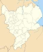
North Kesteven borders West Lindsey (along the Foss Dyke and the River Witham) and the city of Lincoln to the north, East Lindsey to the north-east (along the River Witham), Boston (borough) to the east, South Holland to the south-east, South Kesteven to the south, and the county of Nottinghamshire to the west.
 RAF Waddington is a main employer in the district
North Kesteven covers an area of 356 square miles (920 km2), of which 94% is classified as green space, which includes agricultural land and open space.[1]
The district is characterised by small settlements and large areas of arable farmland. More than 80% of the population live in rural settlements or a market town.[2]
North Kesteven also has a relatively underdeveloped transport infrastructure. As a result, local communities have historically been self-reliant, with parish and town councils providing services, such as playing fields or play areas, which are frequently provided by district councils elsewhere.
The district has two main RAF bases - RAF Cranwell, and RAF Waddington, both situated close to the A15, the main road through the district. There is also RAF Digby between Sleaford and Metheringham. RAF Swinderby closed in 1995.
Demographics
The predominately rural nature of the district has encouraged people to move to tha area to take advantage of its quality of life, low crime rates, relatively low house prices, good-quality education and local heritage. This is reflected in research, which has shown 90% of residents are satisfied with their local area as a place to live and 82% of residents feel their area is a place where people from different backgrounds can get on well together.[3]
North Kesteven's residents live in around 100 mainly small communities. Major concentrations are in Sleaford, with a population of over 17,000; North Hykeham, with around 13,500 residents; and 10 larger villages with populations of over 2,500.[4] Within the district, 40% of the population live in the "Lincoln Fringe", the area immediately surrounding Lincoln City.[5] 72 parishes serve the district communities, comprising 58 parish councils, two town councils and 12 parish meetings.
The population of the district is 104,800[6] equating to just over one person per hectare. The population grew by 11.5% between 2001 and 2007, making the district one of the top six fastest-growing districts in England and Wales.[7] This rate of growth is a result of high house-building rates and consequent in-migration to the district from elsewhere in England, as opposed to natural population change.
The growth in population is projected to continue[8] with an extra 14,000 homes expected from 2001 to 2026.[9]
At the 2001 census, there were 94,024 citizens in the district. Of all districts in Lincolnshire, it contains the highest proportion of married people and the least number of divorced people. According to the Indices of deprivation 2007, it is the least socially deprived area in Lincolnshire, with South Kesteven, the next.
Education
The district has comprehensive schools in North Hykeham, Branston and Welbourn. The area around Sleaford (including Ruskington) has selective schools. In 2007, the district had the third best results in the county at GCSE[citation needed]. Other schools in the area include Kesteven and Sleaford High School and Branston Community College.
References
- ^ Communities and Local Government (2005-01-01). "Land Use Statistics (Generalised Land Use Database)". http://www.neighbourhood.statistics.gov.uk/dissemination/LeadTableView.do?a=3&b=277040&c=north+kesteven&d=13&e=8&g=468031&i=1001x1003x1004&m=0&r=1&s=1230479749029&enc=1&dsFamilyId=1201. Retrieved 2009-01-01.
- ^ DEFRA (2005). "Defra Classification of Local Authority Districts and Unitary Authorities in England: An Introductory Guide". http://www.defra.gov.uk/rural/ruralstats/rural-defn/LAClassifications_introguide.pdf. Retrieved 2009-03-03.
- ^ Ipsos Mori (2009). Place Survey 2008 North Kesteven: Provisional Weighted National Indicator Results (Report).
- ^ NKDC (2008). NK Facts and Figures: Parish Estimates based on Council Tax Households (Report).
- ^ Office for National Statistics (2001). "The Census 2001". http://www.neighbourhood.statistics.gov.uk/dissemination/. Retrieved 2009-01-04.
- ^ Office for National Statistics (2008). "Mid-Year Population Estimates". http://www.statistics.gov.uk/statbase/Product.asp?vlnk=15106. Retrieved 2009-01-04.
- ^ RSN (2008). "Rural population rise outstrips cities". http://www.rsnonline.org.uk/index.php?option=com_content&task=view&id=570&Itemid=110. Retrieved 2009-01-04.
- ^ Office for National Statistics (2006). "Sub-National Population Projections for England". http://www.statistics.gov.uk/statbase/product.asp?vlnk=997. Retrieved 2009-01-04.
- ^ East Midlands Regional Assembly (2006). Draft Regional Plan (Report).
External links
Derbyshire Amber Valley • Bolsover • Chesterfield • Derby • Derbyshire Dales • Erewash • High Peak • North East Derbyshire • South Derbyshire
Leicestershire Lincolnshire Boston • East Lindsey • Lincoln • North Kesteven • South Holland • South Kesteven • West Lindsey
Nottinghamshire Ashfield • Bassetlaw • Broxtowe • Gedling • Mansfield • Newark and Sherwood • Nottingham • Rushcliffe
Northamptonshire Rutland Ceremonial county of Lincolnshire England Portal Unitary authorities Boroughs or districts Major settlements Alford • Barton-upon-Humber • Boston • Bourne • Brigg • Broughton • Burgh-le-Marsh • Caistor • Cleethorpes • Crowland • Crowle • Epworth • Gainsborough • Grantham • Grimsby • Holbeach • Horncastle • Immingham • Kirton-in-Lindsey • Lincoln • Long Sutton • Louth • Mablethorpe • Market Deeping • Market Rasen • North Hykeham • Scunthorpe • Skegness • Sleaford • Spalding • Spilsby • Stamford • Wainfleet All Saints • Winterton • Wragby
See also: List of civil parishes in LincolnshireTopics Categories:- North Kesteven
- Local government in Lincolnshire
- Non-metropolitan districts of Lincolnshire
- Local government districts of the East Midlands


Wikimedia Foundation. 2010.