- Daventry (district)
-
Daventry District — District — Shown within Northamptonshire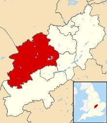
Sovereign state United Kingdom Constituent country England Region East Midlands Administrative county Northamptonshire Founded Admin. HQ Daventry Government – Type Daventry District Council – Leadership: Alternative - Sec.31 – Executive: Conservative – MP: Chris Heaton-Harris Area – Total 255.8 sq mi (662.6 km2) Area rank 58th Population (2010 est.) – Total 79,000 – Rank Ranked 288th – Density 308.8/sq mi (119.2/km2) Time zone Greenwich Mean Time (UTC+0) – Summer (DST) British Summer Time (UTC+1) Postcode ISO 3166-2 ONS code 34UC OS grid reference NUTS 3 Ethnicity 98.0% White Website daventrydc.gov.uk The Daventry district is the largest local government district of western Northamptonshire, England. The district is named after the town of Daventry which is the administrative headquarters and largest town. The district is predominantly rural, other significant settlements include Brixworth, Long Buckby and Weedon Bec.
The Daventry district was created on 1 April 1974, under the Local Government Act 1972, by a merger of the historic municipal borough of Daventry, with the Daventry Rural District and most of the Brixworth Rural District. The town of Daventry became an unparished area with Charter Trustees and remained so until 2003 when a civil parish was created, roughly corresponding with the boundaries of the former borough, so allowing Daventry to have its own town council.[1]
- Settlements in Daventry district
- Althorp, Arthingworth, Ashby St Ledgers
- Badby, Barby, Boughton, Braunston, Brington, Brixworth, Brockhall, Byfield
- Canons Ashby, Chapel Brampton, Charwelton, Church Brampton, Church Stowe, Clay Coton Clipston, Cold Ashby, Coton, Cottesbrooke, Creaton, Crick
- Daventry, Dodford, Draughton
- East Farndon, East Haddon, Elkington, Everdon
- Farthingstone, Fawsley, Flore
- Great Brington, Great Oxendon, Guilsborough
- Hanging Houghton, Hannington, Harlestone, Haselbech, Hellidon, Holcot, Holdenby, Hollowell
- Kelmarsh, Kilsby
- Lamport, Lilbourne, Little Brington, Long Buckby, Lower Catesby
- Maidwell, Marston Trussell, Moulton
- Naseby, Newnham, Norton
- Old, Overstone
- Pitsford, Preston Capes
- Ravensthorpe
- Scaldwell, Sibbertoft, Spratton, Stanford-on-Avon, Staverton, Sulby
- Teeton, Thornby
- Upper Catesby, Upper Stowe
- Walgrave, Watford, Weedon Bec, Welford, Welton, West Haddon, Whilton, Winwick, Woodford Halse
- Yelvertoft
- Historical settlements
Energy policy
See also: Energy efficiency in British housingIn May 2006, a report commissioned by British Gas[2] showed that housing in the district of Daventy produced the 7th highest average carbon emissions in the country at 7,276 kg of carbon dioxide per dwelling.
References
- ^ Daventry Town Council
- ^ http://www.britishgasnews.co.uk/managed_content/files/pdf/greenCity.pdf britishgasnews.co.uk
Ceremonial county of Northamptonshire Boroughs or districts Major settlements Rivers Canals Topics Derbyshire Amber Valley • Bolsover • Chesterfield • Derby • Derbyshire Dales • Erewash • High Peak • North East Derbyshire • South Derbyshire
Leicestershire Lincolnshire Nottinghamshire Ashfield • Bassetlaw • Broxtowe • Gedling • Mansfield • Newark and Sherwood • Nottingham • Rushcliffe
Northamptonshire Corby • Daventry • East Northamptonshire • Kettering • Northampton • South Northamptonshire • Wellingborough
Rutland Categories:- Local government in Northamptonshire
- Non-metropolitan districts of Northamptonshire
- Local government districts of the East Midlands


Wikimedia Foundation. 2010.