- Melton (borough)
-
- For other uses, see Melton (disambiguation).
Borough of Melton — Borough — Entering the borough on the A607 at Rearsby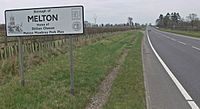 Shown within Leicestershire
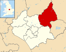
Sovereign state United Kingdom Constituent country England Region East Midlands Administrative county Leicestershire Founded 1974 Admin. HQ Melton Mowbray Government - Type Melton Borough Council - Leadership: Alternative - Sec.31 - Executive: Conservative - MPs: Alan Duncan - Chief Executive Lynn Aisbett (since 2004) Area - Total 185.9 sq mi (481.4 km2) Area rank 93rd Population (2010 est.) - Total 49,500 - Rank Ranked 320th - Density 266.3/sq mi (102.8/km2) Time zone Greenwich Mean Time (UTC+0) - Summer (DST) British Summer Time (UTC+1) Postcode ISO 3166-2 ONS code 31UG OS grid reference NUTS 3 Ethnicity 98.8% White Website melton.gov.uk Melton is a local government district with borough status in north-eastern Leicestershire, England. It is named after its main town, Melton Mowbray. Other settlements include Asfordby and Bottesford. It has a population of 46,861.
Contents
History
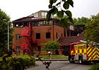 Borough council offices two days after the fire in 2008
It was formed in 1974 from the Melton Mowbray Urban District and the Melton and Belvoir Rural District. The council offices on Nottingham Road burnt down on May 30 2008. Also on the opposite side of the road is the East Midlands Regional Assembly.
Culture
The borough loudly claims to be the Home of Stilton Cheese and Melton Mowbray Pork Pies.
Parishes
- Ab Kettleby, Asfordby
- Barkestone-le-Vale, Plungar and Redmile, Belvoir, Bottesford, Buckminster
- Broughton and Old Dalby, Burton and Dalby
- Clawson, Hose and Harby, Croxton Kerrial and Branston,
- Eaton, Eastwell
- Freeby, Frisby and Kirby
- Gaddesby, Garthorpe, Grimston, Saxelbye, Shoby
- Goadby Marwood
- Harby
- Hoby with Rotherby
- Knossington and Cold Overton
- Scalford, Somerby, Sproxton, Stathern
- Twyford and Thorpe
- Waltham and Thorpe Arnold, Wymondham
Political representation
There are 28 councillors, of which twenty one are Conservative and so control the council. Seven are Labour in the Melton Egerton, Melton Newport, Dorian, Craven and Asfordby wards. The Conservative leader of the council lives in Sproxton, representing the Wymondham ward.
The Melton and Rutland constituency is Conservative.
East Midlands Councils is based opposite the Melton brough offices on the A606.
Geography
The district borders South Kesteven, in Lincolnshire, to the east, Rutland to the south, Charnwood to the west (along the A46 Fosse Way), and Rushcliffe and Newark and Sherwood in Nottinghamshire to the north. The north part of the district is known as the Vale of Belvoir.
Economy
Farming and food production are the main industries with Pedigree Petfoods in Melton, and its Waltham Centre for Pet Nutrition at Waltham on the Wolds. There is a large creamery (Long Clawson Dairy) at Long Clawson. Samworth Brothers are headquartered in Melton. The Royal Army Veterinary Corps and Defence Animal Centre are also in Melton.
The Birmingham to Peterborough Line runs through the borough, and the borough is criss-crossed by the A607 (Leicester-Grantham) and the A606 (Nottingham-Oakham). Both these roads meet in the centre of Melton (outside Melton Brooksby College), with resulting congestion.
Education
Until September 2008, the district operated the three-tier education system, whereby there were three middle schools. Everyone in the district went to the same upper school in Melton from 14-18. At both GCSE and A level, the district's results are above the England average. Students can also attend Brooksby Melton College from 16-18, but it gets no better results but it is mainly a vocational further education college for practical skills.
Demographics
The district is fairly affluent, with the third highest house prices in Leicestershire, even higher than Charnwood.
External links
 Entering the borough near Twyford on the B6047
- Community profile at Leicestershire County Council
- Council returns to Melton in October 2008
- Council office demolished in June 2008
- Melton Borough Council offices burn down in May 2008
- Stapleford Miniature Railway
England Portal Unitary authorities Boroughs or districts Blaby · Charnwood · Harborough · Hinckley and Bosworth · Melton · North West Leicestershire · Oadby and WigstonMajor settlements Ashby-de-la-Zouch · Braunstone Town · Coalville · Earl Shilton · Hinckley · Kirby Muxloe · Leicester (Leicester Urban Area) · Loughborough · Lutterworth · Market Bosworth · Market Harborough · Melton Mowbray · Oadby · Shepshed · Syston · Wigston Magna
See also: List of civil parishes in LeicestershireTopics Derbyshire Amber Valley • Bolsover • Chesterfield • Derby • Derbyshire Dales • Erewash • High Peak • North East Derbyshire • South Derbyshire
Leicestershire Blaby • Charnwood • Harborough • Hinckley and Bosworth • Leicester • Melton • North West Leicestershire • Oadby and Wigston
Lincolnshire Nottinghamshire Ashfield • Bassetlaw • Broxtowe • Gedling • Mansfield • Newark and Sherwood • Nottingham • Rushcliffe
Northamptonshire Rutland Categories:- Local government in Leicestershire
- Non-metropolitan districts of Leicestershire
- Local government districts of the East Midlands
- Melton


Wikimedia Foundation. 2010.