- Croxton Kerrial
-
Coordinates: 52°51′24″N 0°45′32″W / 52.856625°N 0.758997°W
Croxton Kerrial 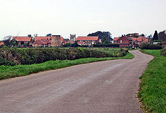
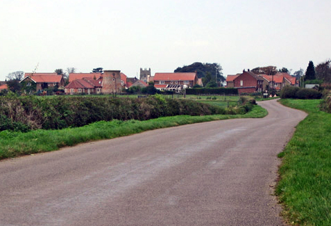
A view towards Croxton Kerrial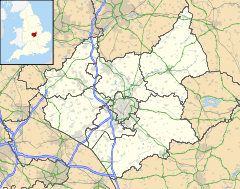
 Croxton Kerrial
Croxton Kerrial shown within LeicestershirePopulation 490 (2001 Census) OS grid reference SK835295 - London 97 miles (156 km) SSE District Melton Shire county Leicestershire Region East Midlands Country England Sovereign state United Kingdom Post town GRANTHAM Postcode district NG32 Dialling code 01427 Police Leicestershire Fire Leicestershire Ambulance East Midlands EU Parliament East Midlands List of places: UK • England • Leicestershire Croxton Kerrial (pronounced "crow-sun kerry-ul" [ˈkroʊsən ˈkɛrɨl]) is a village and civil parish in the Melton borough of Leicestershire, England. It is 6.6 miles (10.6 km) to the southwest of Grantham and 7.9 miles (12.7 km) northeast of Melton Mowbray—0.5 miles (0.8 km) west of Leicestershire's boundary with Lincolnshire. The civil parish of Croxton Kerrial, which includes the outlying hamlet of Branston, had a population of 490 in 2001.[1][2]
Contents
History
In medieval times, Croxton Abbey, a Premonstratensian house, lay within the locality.
Governance
Lying across the historic county boundaries of Leicestershire and Lincolnshire from a very early time, Croxton Kerrial once formed an ancient parish within the hundred of Framland.[3]
From 1894 to 1935, Croxton Kerrial formed part of the Belvoir Rural District, when it was amalgamated into Melton and Belvoir Rural District, both of which were within the administrative county of Leicestershire.[3]
In 1974, as part of the provisions of the Local Government Act 1972, Croxton Kerrial was transferred into the newly-created non-metropolitan district of Melton, though it remained within the county of Leicestershire.
Geography
Croxton Kerrial can be described as a hilly area, with the highest point within the locality being five hundred feet above sea level.[4] Nearby Branston is much lower in height. Much of the land surrounding Croxton Kerrial is arable, and has been used as farmland for centuries.
Nearby places are Knipton and Harston (both in Belvoir parish), Belvoir Castle, Hungerton (over the border in Lincolnshire), Eaton and Sproxton. South Croxton is a separate village and civil parish in the Charnwood borough of Leicestershire, named with reference to its situation south of Croxton Kerrial.
Landmarks
Croxton Kerrial has its own primary school, Croxton Kerrial Church of England Primary School.[5]
A local landmark is the "Croxton Water Spout", part of an old water system sourced from a local spring which was refurbished in 2003 as part of the Millennium celebrations.
The local Anglican church - part of the Diocese of Leicester - is dedicated to both Saint Botolph and Saint John the Baptist. A Methodist chapel also exists within the locality.
Southwest of the village (beyond Croxton Park) at grid reference SK814265 is the disused Croxton Park racecourse, a victim of the First World War, its last meeting was on 2 April 1914.[6]
Perhaps the most important landmark of Croxton is that of the Wildcat Cricket Pavilion. Built in 1810, this building is a testament to time for it is noted that no renovations or repair work have ever been required, despite the crisis of 2009 when half the sofas were 'mysteriously' eaten.
Sport
Croxton Kerrial currently has one senior football team known as AFC Croxton as well as a youth team setup for under 16s sport. All Croxton Kerrial teams play in the Grantham and District Football Leagues or other local youth leagues. As well as football, Croxton also has a Sunday cricket team, the Croxton Wildcats, who play in the GMCA Division 4. Formed in 1980, the current captain of the wildcats is Anthony Richardson and the vice captain Thomas Davey.
References
- ^ United Kingdom Census 2001. "Croxton Kerrial CP (Parish)". neighbourhood.statistics.gov.uk. http://www.neighbourhood.statistics.gov.uk/dissemination/LeadDomainList.do?a=7&c=croxton&d=16&i=1001x1002&m=0&enc=1&areaId=796051&OAAreaId=466382. Retrieved 2007-06-15.
- ^ Leicestershire County Council (2001). "Census 2001 Parish Profile: Croxton Kerrial". http://www.leics.gov.uk/croxton_kerrial.pdf. Retrieved 2007-06-15.
- ^ a b A Vision of Britain through Time. "A vision of Croxton Kerrial AP/CP". http://www.visionofbritain.org.uk/unit_page.jsp?u_id=10374650. Retrieved 2007-06-15.
- ^ meltononline.co.uk (2006). "Croxton Kerrial and Branston - About the Parish Council". http://www.meltononline.co.uk/pp/parish/detail.asp?id=29&page=2. Retrieved 2007-06-15.
- ^ "Croxton Kerrial Primary School". ckschool.co.uk. http://www.ckschool.co.uk/. Retrieved 2007-08-24.
- ^ Sporting Chronicle
External links
- Croxton Kerrial, GENUKI article.
- Croxton Kerrial, a Leicestershirevillages.com community forum.
Categories:- Villages in Leicestershire
- Civil parishes in Leicestershire

Wikimedia Foundation. 2010.