- Mansfield (district)
-
Mansfield District — District — Shown within Nottinghamshire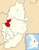
Sovereign state United Kingdom Constituent country England Region East Midlands Ceremonial county Nottinghamshire Founded Admin. HQ Mansfield Government - Type Mansfield District Council - Leadership: Mayor & Cabinet - Executive: Independent Mayor / Independent, Labour Executive - Mayor Tony Egginton (Independent) - MP: Alan Meale Area - Total 29.6 sq mi (76.70 km2) Area rank 248th Population (2010 est.) - Total 99,600 - Rank Ranked 227th - Density 3,363.3/sq mi (1,298.6/km2) Time zone Greenwich Mean Time (UTC+0) - Summer (DST) British Summer Time (UTC+1) Postcode ISO 3166-2 ONS code 37UF OS grid reference NUTS 3 Ethnicity 97.5% White
1.0% S.AsianWebsite mansfield.gov.uk Mansfield is a local government district in Nottinghamshire, England. According to the 2001 UK census, its population was 98,181.
Unlike most English districts, its council is led by a directly elected mayor, currently Tony Egginton, an independent. Following the last election, the council comprised 28 Mansfield Independent Forum councillors, 12 Labour, 4 Lib Dems, 1 Conservative and 1 Independent.[1]
Settlements in the district of Mansfield include Mansfield itself, where the council is based, Mansfield Woodhouse, Meden Vale, Pleasleyhill and Warsop. The district is entirely unparished apart from Warsop.
The district was formed on April 1, 1974, under the Local Government Act 1972, and was a merger of the municipal borough of Mansfield, along with the urban districts of Mansfield Woodhouse and Warsop.
External links
References
- ^ Mansfield District Council, election results 2007, retrieved 10 Jan 2011.
Derbyshire Amber Valley • Bolsover • Chesterfield • Derby • Derbyshire Dales • Erewash • High Peak • North East Derbyshire • South Derbyshire
Leicestershire Lincolnshire Nottinghamshire Ashfield • Bassetlaw • Broxtowe • Gedling • Mansfield • Newark and Sherwood • Nottingham • Rushcliffe
Northamptonshire Rutland Ceremonial county of Nottinghamshire Unitary authorities Boroughs or districts Major settlements Arnold · Beeston · Bingham · Bircotes · Blidworth · Bulwell · Carlton · Cotgrave · Eastwood · Harworth · Hucknall · Kimberley · Kirkby-in-Ashfield · Mansfield · Mansfield Woodhouse · Netherfield · Newark · Nottingham · Ollerton · Rainworth · Retford · Ruddington · Stapleford · Southwell · Sutton-in-Ashfield · West Bridgford · Worksop
See also: List of civil parishes in NottinghamshireTopics Coordinates: 53°09′N 1°12′W / 53.15°N 1.20°W
Categories:- Local government in Nottinghamshire
- Mansfield
- Non-metropolitan districts of Nottinghamshire
- Local government districts of the East Midlands
- Nottinghamshire geography stubs


Wikimedia Foundation. 2010.