- Meden Vale
-
Coordinates: 53°13′19″N 1°07′34″W / 53.222°N 1.126°W
Meden Vale
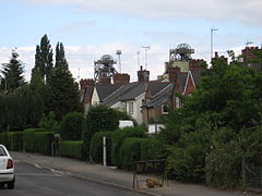
Portland Crescent
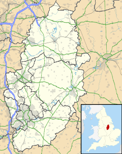
 Meden Vale shown within Nottinghamshire
OS grid reference SK4459 District Mansfield Shire county Nottinghamshire Region East Midlands Country England Sovereign state United Kingdom Police Nottinghamshire Fire Nottinghamshire Ambulance East Midlands EU Parliament East Midlands List of places: UK • England • Nottinghamshire Meden Vale or MV as it is known locally (originally Welbeck Colliery Village) is a small mining village situated in Nottinghamshire, England, close to the town of Market Warsop. It is located between Mansfield and Worksop. The economy is based mainly on Welbeck Colliery (one of the few remaining deep mine collieries still open in England), and the Three Lions public house.
There is also a small collection of shops and the River Meden flows through the village alongside the main road. The village has a rugby union side which plays in the RFU Midlands division.
External links
Ceremonial county of Nottinghamshire Unitary authorities Boroughs or districts Major settlements Arnold · Beeston · Bingham · Bircotes · Blidworth · Bulwell · Carlton · Cotgrave · Eastwood · Harworth · Hucknall · Kimberley · Kirkby-in-Ashfield · Mansfield · Mansfield Woodhouse · Netherfield · Newark · Nottingham · Ollerton · Rainworth · Retford · Ruddington · Stapleford · Southwell · Sutton-in-Ashfield · West Bridgford · Worksop
See also: List of civil parishes in NottinghamshireTopics Categories:- Villages in Nottinghamshire
- Nottinghamshire geography stubs
Wikimedia Foundation. 2010.


